-

Southern California (10)
Original antique maps of Southern California, including Los Angeles and Santa Barbara. -
-
Add to cart
![נמל סן פרנסיסקו איפה מתחיל המזרח הרחוק [Port of San Francisco Where the Far East Begins].](https://neatlinemaps.com/wp-content/uploads/2025/11/NL-02485_thumbnail-300x300.jpg) Quick View
Quick View - Bird's-eye-views, California, San Francisco
נמל סן פרנסיסקו איפה מתחיל המזרח הרחוק [Port of San Francisco Where the Far East Begins].
- $1,600
- Stylized Hebrew Version!
-
-
-
-
Add to cart
 Quick View
 - Bay Area & Silicon Valley, California
Map of Principal East Bay Cities.
- $675
- Unrecorded 1922 Thomas Bros. East Bay wall map.
-
-
-
-
Add to cart
 Quick View
 - Bay Area & Silicon Valley, California
Map of Novato Ranch. Owned by the Novato Ranch Co.
- $975
- Circa 1910 promotional subdivision map of Novato Ranch, showcasing Marin County’s transformation from rancho lands to small farms and suburban homesteads.
-
-
-
-
Add to cart
 Quick View
 - Bay Area & Silicon Valley, California, Pictorial maps
Monterey California. Cannery Row.
- $275
- A colorful 1988 promotional pictorial view of Monterey's famous Cannery Row.
-
-
-
-
Add to cart
 Quick View
 - Bay Area & Silicon Valley, Bird's-eye-views, California, Pictorial maps
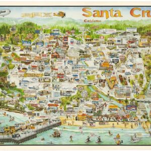
Santa Cruz California.
- $425
- A charming 1988 promotional pictorial view of Santa Cruz, California.
-
-
-
-
Add to cart
 Quick View
 - California, Pictorial maps
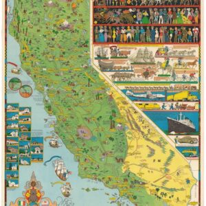
California.
- $1,600
- Jo Mora’s iconic 1945 map of California.
-
-
-
-
Add to cart
![Reconnaissance of the Western Coast of the United States from San Francisco to Umpquah River [&] Voyages of Discovery and Exploration on the Northwest Coast of America from 1539 to 1603.](https://neatlinemaps.com/wp-content/uploads/2021/01/NL-00878_Thumbnail-300x300.jpg) Quick View
Quick View - Atlases & Books, California, Curiosities - Miscellanea
Reconnaissance of the Western Coast of the United States from San Francisco to Umpquah River [&] Voyages of Discovery and Exploration on the Northwest Coast of America from 1539 to 1603.
- $2,400
- Two works linked to historian George Davidson — an annotated Coast Survey chart and a proof copy of his 1887 report on early Pacific Coast exploration.
-
-
-
-
Add to cart
 Quick View
 - Bay Area & Silicon Valley, California
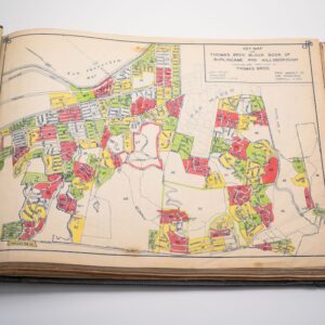
Thomas Bros Block Book of Burlingame and Hillsborough.
- $3,500
- Rare c. 1940 Thomas Bros. block book mapping Hillsborough and Burlingame’s elite Bay Area estates and landowners.
-
-
-
-
Add to cart
 Quick View
 - Atlases & Books, California, San Francisco
The Water Supply of San Francisco California before, during, and after the earthquake of April 18th, 1906, and the subsequent conflagration.
- $375
- Retrospective study on the origins of the 1906 catastrophe.
-
-
-
-
Add to cart
 Quick View
 - California, Southern California
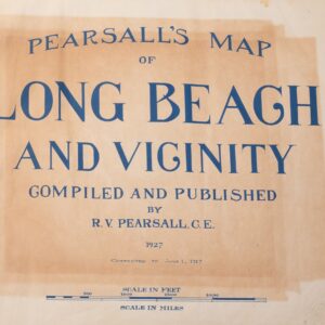
Pearsall’s Map of Long Beach and Vicinity.
- $3,800
- A unique example of Pearsall's 1927 Long Beach plat atlas with added maps and provenance paste-ins.
-
-
-
-
Add to cart
 Quick View
 - California, San Francisco
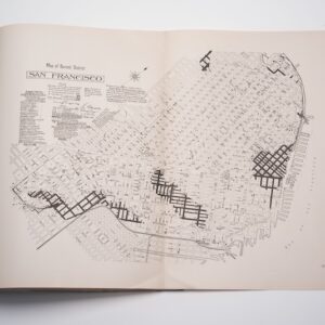
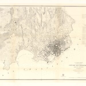
City of San Francisco and its Vicinity.
- $2,200
- A cornerstone map for the historical cartography of San Francisco.
-
-
-
-
Add to cart
 Quick View
 - California
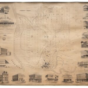
Official Map of the City of Marysville, California. Compiled by N. Wescoatt, City Surveyor, and W. S. Watson, Civil Engineer, from Recent Surveys by N. Wescoatt.
- $4,500
- An exceptional and monumental Gold Rush-era city plan of one of early California’s most prosperous river ports at its peak.
-
-