A Late Renaissance bird’s-eye-view of Florence, with the Medici family crest.
Fiorenza
Out of stock
Description
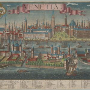
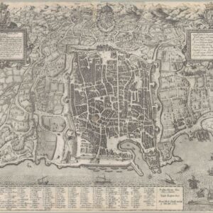
Circa 1600 bird’s-eye-view of Florence by Matteo Florimi, depicting the city in excellent detail. To the right of the title we find the famous Medici family emblem (five balls on a shield), along with the symbol of Florence; on the left side is a compass rose with winds and a map at center.
Within the city, every street, piazza, and thoroughfare is visible, and many of them have been numbered and identified in a legend entitled ‘Notable places’ (Luoghi Notabili) in the lower right corner of the map. Flowing through the heart of the city is of course the great Arno River, which originates in Florence’s mountainous hinterland and empties into the Ligurian Sea at Livorno. Spanning its flow we find Florence’s famous bridges, the oldest and most famous of which is the Ponte Vecchio, characterized by its triple arches and the row of narrow structures on the bridge itself. Built in 1345 after a flood had torn down an even older bridge at this location, the Ponte Vecchio was the only Renaissance bridge in Florence to survive World War II (probably because it was too narrow to accommodate artillery crossings).
Built on the three massive arches which still carry it today, the Ponte Vecchio was originally equipped with a line of butcher shops. Their location on the bridge was initially strategic, as this location allowed them to dump their waste directly into the river below. Gradually, however, this practice created such a serious odor and hygiene problem that it had to be dealt with. The man to do it was Ferdinand I de Medici. He had ascended the throne of the Grand Duke of Tuscany in 1587, after Francesco I (Buonsignori’s patron) had been murdered. Among his earliest initiatives was the permanent removal of the butchers from the bridge, replacing them with the goldsmiths and jewelers who still occupy it today. Our map is smack in the middle of that transition, and from the rather simple units on the bridge, we may well presume that this is one of those rare images that was produced before the famous conversion of Ponte Vecchio to a symbol of the city’s mercantilism and wealth. It is also one of many examples of why this map constitutes a window into a particularly important time for the city.
Stepping into the northern part of the city from Ponte Vecchio, one ascends via the ancient Via Calimala before culminating on the quadratic Piazza della Signoria, which in turn fronts one of Florence’s oldest and most famous buildings, the 13th century Palazzo Vecchio. Moving north from here, one soon ends on the beautiful double-square that constitutes both the geographic and architectural heart of the city. Approaching the square from the river, we find the octagonal Battistero di San Giovanni (Baptistery of St John) on the left, and Brunelleschi’s magnificent dome of the Cattedrale di Santa Maria del Fiore (or il Duomo), completed a century prior, on the right.
In crossing the Ponte alle Grazie, visitors are provided with the only river-view of the magnificent Uffizi Galleries. Begun in 1540 by Giorgio Vasari as offices for the Florentine magistrates (hence the name), by the time the building had been completed in 1581, the upper floor had been converted into the private viewing galleries for the Medici family’s enormous art collection. At the time when this chart was compiled, the Uffizi had only just been completed yet already stood as one of the most celebrated and impressive public buildings in the city.
The city walls themselves date back to the late 13th – early 14th century, but were built on much older foundations. Florence was established around 59 BCE as a Roman colony, and in line with other Roman settlements along the Via Cassia, it was provided with city walls in order to define it as such. Roman Florentia was constructed along the traditional model of a castrum (military encampment), with a major north-south thoroughfare (cardo maximus) and a major east-west one (decumanus) intersecting each other at the heart of the city. Despite continuous growth beyond the scope of the original colony, the Roman orthogonal lay-out dominated town-planning well into the Renaissance, as is evident from this chart. The thoroughfares would usually culminate on monumental and defendable gates, which on our map are readily visible – and in most cases numbered.
When the city began construction of its third generation city wall in the late 13th century, the gates were constructed first. This both ensured that the walls aligned more or less with the existing urban infrastructure, but also provided an anchoring point for the enormous project of erecting the curtain walls. Roman infrastructure, not only of the city, but of the surrounding roads, meant that orientation towards the cardinal points was maintained into the 16th century and beyond. Consequently, the main gates — Porta alla Croce (137), Porta San Gallo (135), and Porta al Prato (133) — face east, north, and west respectively.
Cartographer(s):
Matteo Florimi (active 1581 – 1613) was an editor and bookseller. Originally from Calabria, Florimi settled in Siena in 1581, where he published a variety of important works.
Condition Description
Expert repairs visible. Map image very good.
References
