-
-
Add to cart
 Quick View
 - Africa
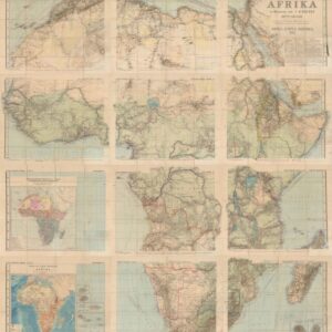
Spezial-Karte von Afrika im Maßstab von 1:4,000,000. Dritte Auflage. Bearbeitet von Hermann Habenicht. Gotha: Justus Perthes, 1892.
- $850
- Landmark 1892 Twelve-Sheet Scientific Map of Africa in its Third Edition, Published Seven Years into the Scramble for Africa.
-
-
-
-
Add to cart
 Quick View
 - British Isles, Europe
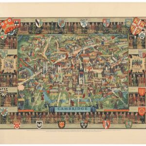
Cambridge: “This immense & glorious work of fine intelligence”.
- $650
- Large 1948 Pictorial Map of the Cambridge University with All College Arms and Buildings in Bird's-Eye View, First Printing on Heavy Paper in Rich Color.
-
-
-
-
Add to cart
 Quick View
 - Europe, Russia & Eastern Europe
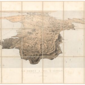
La Crimée à vol d’oiseau.
- $3,500
- Rare 1855 Bird’s-Eye-View of the Crimean Peninsula, Published During the Siege of Sevastopol.
-
-
-
-
Add to cart
 Quick View
 - Asia, India
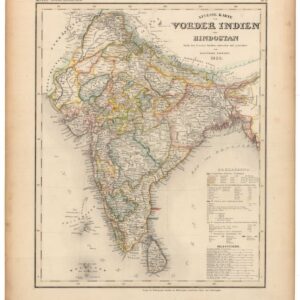
Neueste Karte von Vorder Indien oder Hindostan.
- $200
- 1850 Map of India Showing the Power of the East India Company.
-
-
-
-
Add to cart
 Quick View
 - East & Midwest United States, United States
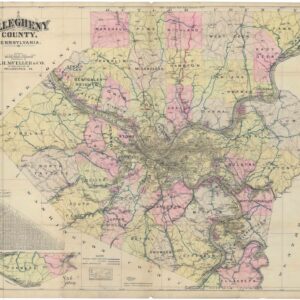
Allegheny County, Pennsylvania. Published by A.H. Mueller & Co., 2nd & 340 Locust St., Philadelphia, PA.
- $475
- Pittsburgh in 1912: Mueller's Large County Road Map at the Moment the Automobile Was Rewriting Every Road in Allegheny County.
-
-
-
-
Add to cart
![Venetia. / L’Altra Parte della Piazza di S. Marco in Venetia. / Piaz[za] Marco di Venetia.](https://neatlinemaps.com/wp-content/uploads/2026/07/NL-02742-view1_thumbnail-300x300.jpg) Quick View
Quick View - Europe, Italy
Venetia. / L’Altra Parte della Piazza di S. Marco in Venetia. / Piaz[za] Marco di Venetia.
- $4,200
- A Unique Item: Three ca. 1640 Merian Views of Venice, Bound Together in Decorative Paper Boards.
-
-
-
-
Add to cart
![Nova Totivs Evropae Tabvla, ex magnis Gerardi de Iudaeis P[atris] desumpta…](https://neatlinemaps.com/wp-content/uploads/2026/07/NL-02707_thumbnail-300x300.jpg) Quick View
Quick View - Europe
Nova Totivs Evropae Tabvla, ex magnis Gerardi de Iudaeis P[atris] desumpta…
- $9,400
- Phantom Islands in the Atlantic and Twenty Costume Figures: De Jode's Rare 1593 Map of Europe in Excellent Original Color.
-
-
-
-
Add to cart
 Quick View
 - California, Southern California
Johnny Carson Welcomes You to Beautiful Downtown Burbank.
- $1,600
- The Running Joke Became a Real Place — 1981 Pictorial Map of Johnny Carson Welcomes You to Beautiful Downtown Burbank.
-
-
-
-
Add to cart
 Quick View
 - Africa, Egypt
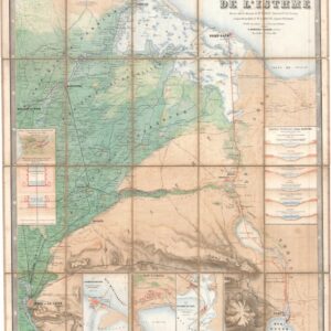
Compagnie universelle du canal maritime de Suez. Carte de l’Isthme.
- $5,000
- 1866 First Edition Map of the Suez Canal, Printed Before the Canal's Completion and Later Pirated by the Imperial German Army.
-
-
-
-
Add to cart
![[La Nuova Topografia di Roma] — Piazza del Popolo, the Spanish Steps, and the Villa Borghese.](https://neatlinemaps.com/wp-content/uploads/2026/07/NL-02640_thumbnail-300x300.jpg) Quick View
Quick View - Europe, Italy
[La Nuova Topografia di Roma] — Piazza del Popolo, the Spanish Steps, and the Villa Borghese.
- $1,600
- The Grand Tour's First View of Rome, from the Gate to the Steps.
-
-
-
-
Add to cart
![[La Nuova Topografia di Roma] — The Vatican, St. Peter’s Basilica, and Castel Sant’Angelo.](https://neatlinemaps.com/wp-content/uploads/2026/07/NL-02639_thumbnail-300x300.jpg) Quick View
Quick View - Europe, Italy
[La Nuova Topografia di Roma] — The Vatican, St. Peter’s Basilica, and Castel Sant’Angelo.
- $1,800
- Rome's Most Sacred Quarter, from One of the Greatest Urban Maps Ever Made.
-
-
-
-
Add to cart
 Quick View
 - Egypt, Middle East - Holy Land Maps
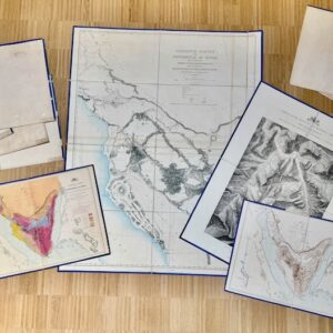
Ordnance Survey of the Peninsula of Sinai. Charles William Wilson and Henry Spencer Palmer. Southampton: Ordnance Survey Office, 1869–1870. Maps, Plans and Sections.
- $5,500
- Where Exodus Happened: 1869–1870 Complete Ten Map Portfolio of the Ordnance Survey of the Peninsula of Sinai.
-
-
Shop
All maps in stock, sorted by latest.