-
-
Add to cart
![In Omaggio alle Glorie della Scienza Elettro-Galvanica [In homage to the glories of electro-galvanic science].](https://neatlinemaps.com/wp-content/uploads/2026/06/NL-02695_thumbnail-300x300.jpg) Quick View
Quick View - Curiosities - Miscellanea
In Omaggio alle Glorie della Scienza Elettro-Galvanica [In homage to the glories of electro-galvanic science].
- $1,600
- Unrecorded c. 1900 Italian Commemorative Lithographic Broadside Honoring Galvani, Volta, Ferraris, and Marconi.
-
-
-
-
Add to cart
 Quick View
 - Curiosities - Miscellanea, Pictorial maps, World
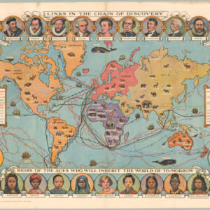
Cassell’s Children’s Book of Knowledge Wonder Map of the World.
- $450
- Thematic mapping for children: a fabulous circa 1930 world map depicting the history of exploration.
-
-
-
-
-
Add to cart
 Quick View
 - Curiosities - Miscellanea, World
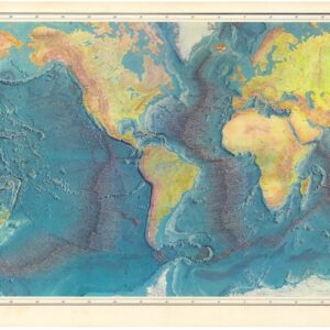
World Ocean Floor.
- $1,800
- 1977 Heezen & Tharp World Ocean Floor Map.
-
-
-
-
Add to cart
![Emigranter till det nya Jerusalem, Frälsarens Kungliga Linie [Emigrants to the New Jerusalem, the Savior’s Royal Line].](https://neatlinemaps.com/wp-content/uploads/2026/04/NL-02567_thumbnail-300x300.jpg) Quick View
Quick View - Curiosities - Miscellanea, Eastern Mediterranean - Holy Land, Middle East - Holy Land Maps
Emigranter till det nya Jerusalem, Frälsarens Kungliga Linie [Emigrants to the New Jerusalem, the Savior’s Royal Line].
- $975
- 1902 circa Swedish Allegorical Broadside — Emigrants to the New Jerusalem.
-
-
-
-
Add to cart
 Quick View
 - Curiosities - Miscellanea, World
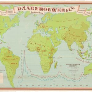
Daarnhouwer & Co — Established 1908 — Countries of Origin for the Major Spices.
- $375
- 1971 Thematic World Map of the Global Spice Trade.
-
-
-
-
Add to cart
 Quick View
 - Curiosities - Miscellanea, Europe, World War I and World War II
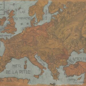
L’instanté de l’Europe et de l’Asie mineure, 1914.
- $1,250
- A fantastic hand-drawn World War I curiosity.
-
-
-
-
Add to cart
 Quick View
 - Curiosities - Miscellanea, World
Le Microscope moderne.
- $4,000
- Anticipating Flat-Earth Thought.
-
-
-
-
Add to cart
 Quick View
 - Curiosities - Miscellanea
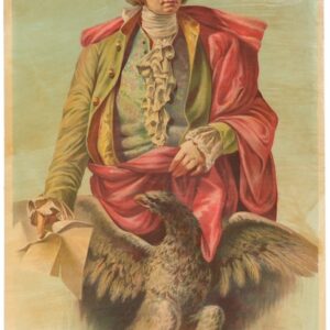
George Washington – A. De Felice & Co. Societa Agrumaria Rodi.
- $675
- George Washington as a citrus salesman.
-
-
-
-
Add to cart
![[Large French Manuscript World Map].](https://neatlinemaps.com/wp-content/uploads/2025/12/NL-02491_thumbnail-300x300.jpg) Quick View
Quick View - Curiosities - Miscellanea, World
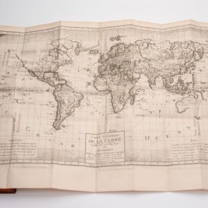
[Large French Manuscript World Map].
- $1,200
- Elegant Hand-Drawn French Map of the World.
-
-
-
-
Add to cart
![[Ortelius & Hogenberg Atlas Factice]](https://neatlinemaps.com/wp-content/uploads/2023/03/NL-01678-leo-belgicus-3_thumbnail-300x300.jpg) Quick View
Quick View - Atlases & Books, Curiosities - Miscellanea, Europe, Germany & the Netherlands
[Ortelius & Hogenberg Atlas Factice]
- $28,000
- Fascinating Composite Dutch Atlas. With Frans Hogenberg’s very rare Germaniae Inferioris and Eytzinger’s Leo Belgicus. Bound in a unique double-folding format for travel.
-
-
-
-
Add to cart
 Quick View
 - Curiosities - Miscellanea, Europe, Germany & the Netherlands
Wein aus Deutschen Landen.
- $350
- Rare poster-map of the German wine country.
-
-
-
-
Add to cart
![Reconnaissance of the Western Coast of the United States from San Francisco to Umpquah River [&] Voyages of Discovery and Exploration on the Northwest Coast of America from 1539 to 1603.](https://neatlinemaps.com/wp-content/uploads/2021/01/NL-00878_Thumbnail-300x300.jpg) Quick View
Quick View - Atlases & Books, California, Curiosities - Miscellanea
Reconnaissance of the Western Coast of the United States from San Francisco to Umpquah River [&] Voyages of Discovery and Exploration on the Northwest Coast of America from 1539 to 1603.
- $2,400
- Two works linked to historian George Davidson — an annotated Coast Survey chart and a proof copy of his 1887 report on early Pacific Coast exploration.
-
-