-
-
Add to cart
 Quick View
 - Americas, Mexico - Central & South America
Brasilia et Peruvia.
- $10,500
- De Jode's 1593 South America in Exceptional Original Color.
-
-
-
-
Add to cart
 Quick View
 - Americas, Mexico - Central & South America
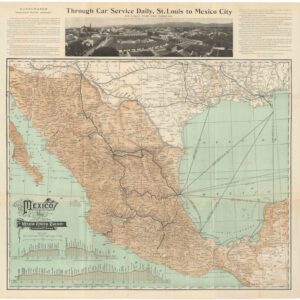
Mexico — Map of the Mexican Central Railway and Connections.
- $475
- 1908 Mexican Central Railway Map of Mexico.
-
-
-
-
Add to cart
 Quick View
 - Americas, Mexico - Central & South America
Panama – Canal.
- $975
- Early 20th-century bird's-eye teaching chart of the Panama Canal.
-
-
-
-
Add to cart
![[Persuasive Cartography] La Cuestión Chilena.](https://neatlinemaps.com/wp-content/uploads/2025/10/NL-02415_thumbnail-300x300.jpg) Quick View
Quick View - Americas, Mexico - Central & South America
[Persuasive Cartography] La Cuestión Chilena.
- $975
- Argentinian propaganda map of Chile’s advance into Patagonia.
-
-
-
-
Add to cart
 Quick View
 - Americas, Mexico - Central & South America, North America
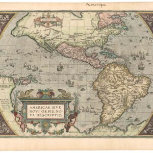
Americae Sive Novi Orbis, Nova Descriptio.
- $4,800
- The earliest acquirable map to name California.
-
-
-
-
Add to cart
 Quick View
 - California, Mexico - Central & South America, Texas and The West
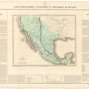
Carte Geographique, Statistique, et Historique du Mexique (incl. Alta California).
- $475
- The First Mexican Empire, including Alta California.
-
-
-
-
Add to cart
 Quick View
 - Americas, Mexico - Central & South America
World Petroleum Oil Map of Columbia.
- $500
- An American map of oil and petroleum resources in Columbia.
-
-
-
-
Add to cart
 Quick View
 - Americas, Mexico - Central & South America
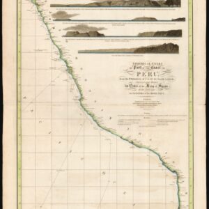
Spherical chart of part of the coast of Peru, from the Parallel of 7.° to 21.° 45.’ South Latititude; Surveyed and Drawn by Order of the King of Spain in the year 1790, By Officers of the Royal Navy.
- $950
- The best coastal view of Peru in the early 19th century.
-
-
-
-
Add to cart
 Quick View
 - Americas, Mexico - Central & South America
Archaeological Map of the Guatemala.
- $325
- An archaeological map depicting Guatemala’s extensive Mayan ruins.
-
-
-
-
Add to cart
 Quick View
 - Mexico - Central & South America
Archaeological Map of the Yucatan Peninsula.
- $475
- An archaeological map depicting the extensive Mayan ruins of the Yucatan Peninsula.
-
-
-
-
Add to cart
 Quick View
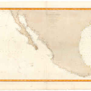
 - Texas and The West, Americas, Mexico - Central & South America
Carte de la côte occidentale d’Amérique…
- $875
- Nautical chart of Mexico, including San Diego and the Texas coast.
-
-
-
-
Add to cart
 Quick View
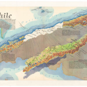
 - Americas, Mexico - Central & South America
Chile
- $675
- A distinctive, mind-bending view of Chile.
-
-