-
-
Add to cart
![[Untitled Sectional County Map of Colorado]](https://neatlinemaps.com/wp-content/uploads/2026/05/NL-02489_thumbnail-300x300.jpg) Quick View
Quick View - Texas and The West, United States
[Untitled Sectional County Map of Colorado]
- $500
- 1905 circa Large-Format Wall Map of Colorado at the Height of the Western Boom.
-
-
-
-
Add to cart
![[Pictorial Map of Oahu] / Piggy Bank Rates on U-Drives (verso).](https://neatlinemaps.com/wp-content/uploads/2026/05/NL-02591_thumbnail-300x300.jpg) Quick View
Quick View - Pacific Northwest - Hawaii - Alaska, United States
[Pictorial Map of Oahu] / Piggy Bank Rates on U-Drives (verso).
- $175
- Piggy Bank Rates and Diamond Head — Oahu in 1965.
-
-
-
-
Add to cart
![The Island of Hawaii, The Big Island of the Territory of Hawaii… [with] Street Map of Hilo showing points of interest (verso).](https://neatlinemaps.com/wp-content/uploads/2026/05/NL-02590_thumbnail-300x300.jpg) Quick View
Quick View - Pacific Northwest - Hawaii - Alaska, United States
The Island of Hawaii, The Big Island of the Territory of Hawaii… [with] Street Map of Hilo showing points of interest (verso).
- $275
- [First edition?] Ruth Taylor White Pictorial Map of the Island of Hawaii.
-
-
-
-
Add to cart
![North Pacific Coast Hawaiian Islands South Coast of Oahu Pearl Harbor [Confidential].](https://neatlinemaps.com/wp-content/uploads/2026/04/NL-02556_thumbnail-300x300.jpg) Quick View
Quick View - Pacific Northwest - Hawaii - Alaska, United States, World War I and World War II
North Pacific Coast Hawaiian Islands South Coast of Oahu Pearl Harbor [Confidential].
- $1,400
- 1944 U.S. Navy Confidential Nautical Chart of Pearl Harbor, with post-Attack modifications.
-
-
-
-
Add to cart
 Quick View
 - East & Midwest United States, United States
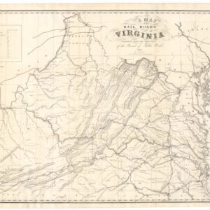
A Map of the Rail Roads of Virginia Prepared Under the Direction of the Board of Public Works.
- $4,800
- Rare Pre-Civil War Virginia Railroad Map Printed in Richmond, 1858.
-
-
-
-
Add to cart
 Quick View
 - East & Midwest United States, United States
Gettysburg. Repulse of Longstreet’s Assault.
- $900
- Bachelder’s magnificent rendering of Longstreet’s Assault (Pickett's Charge).
-
-
-
-
Add to cart
 Quick View
 - East & Midwest United States, Featured Maps & Views, United States
Gettysburg Battle-Field.
- $2,400
- Bachelder's iconic 1863 view of the Battle of Gettysburg.
-
-
-
-
Add to cart
 Quick View
 - East & Midwest United States, United States
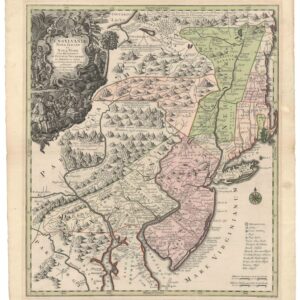
Pensylvania Nova Jersey et Nova York cum Regionibus Ad Fluvium Delaware…
- $2,900
- Seutter’s first state map of Pennsylvania, Jersey, and New York, with original color.
-
-
-
-
Add to cart
 Quick View
 - Atlases & Books, Canada and The Great Lakes, North America, United States
Reports upon the Survey of the Boundary between the Territory of the United States and the Possessions of Great Britain. Washington: Government Printing Office, 1878.
- $500
- 1878 U.S. report on the survey that fixed the U.S.–Canadian border along the 49th parallel.
-
-
-
-
Add to cart
 Quick View
 - Atlases & Books, Canada and The Great Lakes, North America, United States
Joint maps of the northern boundary of the United States: from the Lake of the Woods to the summit of the Rocky Mountains.
- $500
- Defining the U.S.–Canadian border along the 49th parallel from the Lake of the Woods to the Rockies.
-
-
-
-
Add to cart
 Quick View
 - Americas, North America, United States
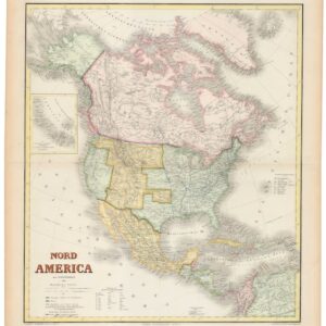
Nord America mit Westindien.
- $975
- Hand-colored ca. 1867 Kiepert map of North America, capturing the post-Civil War U.S., shifting Canadian and Mexican frontiers, and colonial Caribbean.
-
-
-
-
Add to cart
 Quick View
 - Atlases & Books, California, Texas and The West
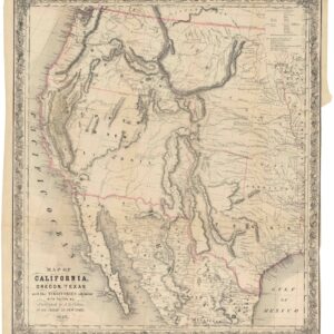
Map of California, Oregon, Texas, and the territories adjoining, with routes &c.
- $1,900
- Colton’s iconic map of the West, with California Gold region and extended Texas borders.
-
-
