-
-
Add to cart
 Quick View
 - Africa, Egypt
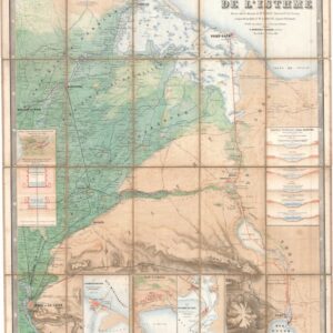
Compagnie universelle du canal maritime de Suez. Carte de l’Isthme.
- $5,000
- 1866 First Edition Map of the Suez Canal, Printed Before the Canal's Completion and Later Pirated by the Imperial German Army.
-
-
-
-
Add to cart
 Quick View
 - Egypt, Middle East - Holy Land Maps
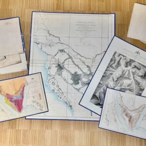
Ordnance Survey of the Peninsula of Sinai. Charles William Wilson and Henry Spencer Palmer. Southampton: Ordnance Survey Office, 1869–1870. Maps, Plans and Sections.
- $5,500
- Where Exodus Happened: 1869–1870 Complete Ten Map Portfolio of the Ordnance Survey of the Peninsula of Sinai.
-
-
-
-
Add to cart
 Quick View
 - Africa
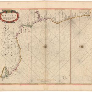
Pas-Caart van Guinea en de Custen daer aen gelegen Van Cabo verde tot Cabo de Bona Esperanca.
- $750
- 1670s Goos Sea Chart of the West African Coast from Cape Verde to the Cape of Good Hope.
-
-
-
-
Add to cart
 Quick View
 - Africa
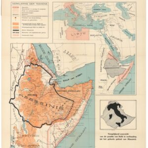
Oorlogskaart van Abessinië. Italiaansche Koloniën en Omiliggende Landen.
- $200
- Circa 1935 War Map of Abyssinia and the Italian Colonies at the Outbreak of the Second Italo-Ethiopian War.
-
-
-
-
Add to cart

 Quick View
 - Africa, Arabia and the Red Sea, Asia, India
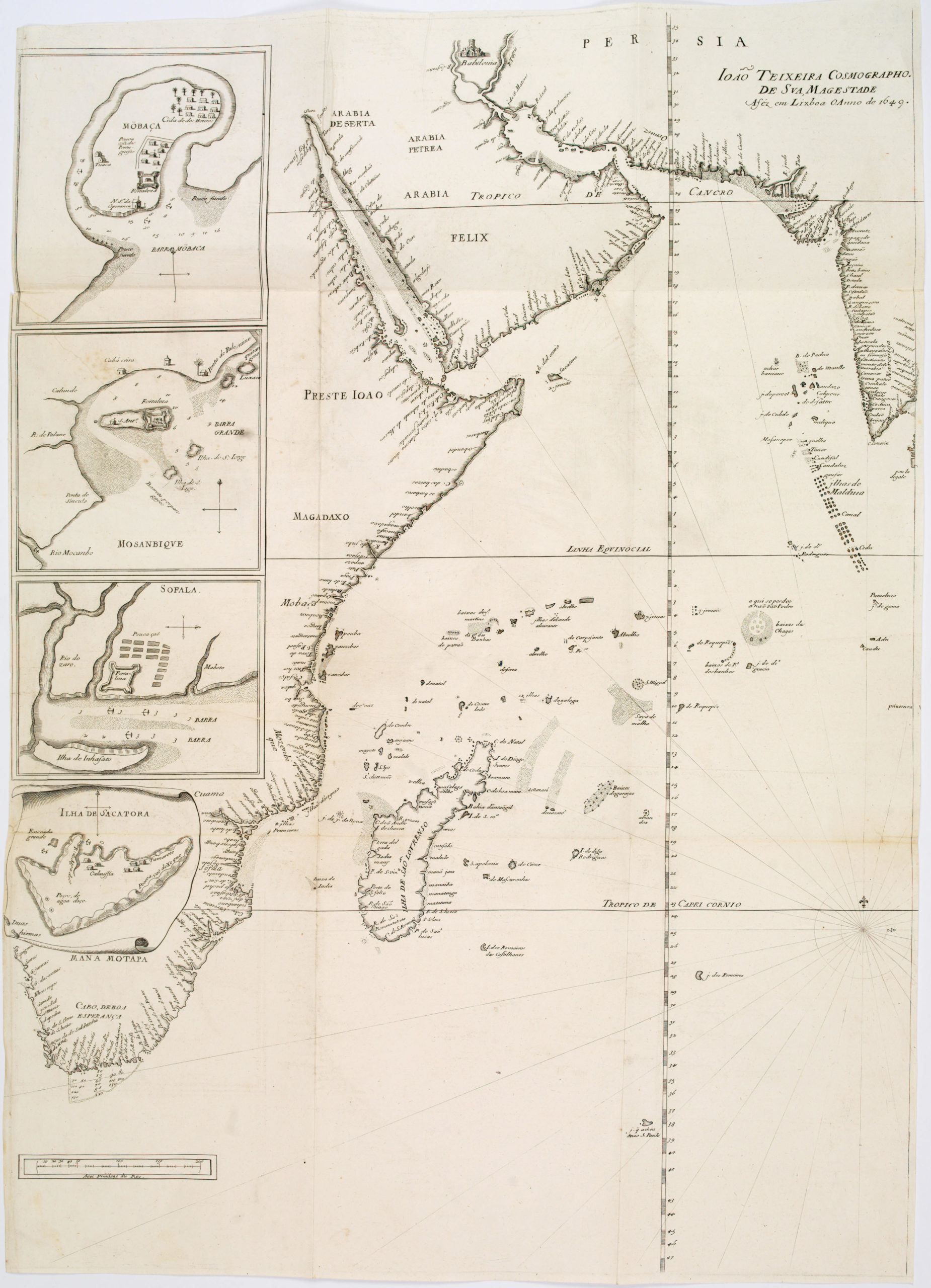
João Teixeira Cosmographo. De sua, Magestade. Aféz em Lixboa o Anno de 1649
- $4,200
- Rare 17th century portolan-style chart designed for use aboard Portuguese merchant vessels.
-
-
-
-
-
Add to cart
 Quick View
 - Africa, Egypt
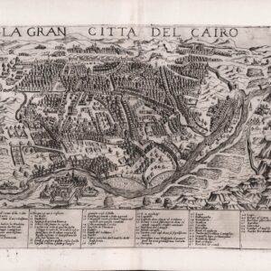
LA GRAN CITTÀ DEL CAIRO.
- $1,600
- One of the earliest printed views of Cairo, with no institutional parallels.
-
-
-
-
Add to cart
![[Mısır Haritası / Map of Egypt]](https://neatlinemaps.com/wp-content/uploads/2025/06/NL-02391_thumbnail-2-300x300.jpg) Quick View
Quick View - Africa, Egypt, Middle East - Holy Land Maps, Turkey - Ottoman Empire, World War I and World War II
[Mısır Haritası / Map of Egypt]
- $1,800
- Strategic Ottoman map of Lower Egypt.
-
-
-
-
Add to cart
![[With Extensive Contemporary Annotations] Ordnance Survey of the Peninsula of Sinai Made in 1868-9.](https://neatlinemaps.com/wp-content/uploads/2020/05/NL-00842_Thumbnail-300x300.jpg)
![[With Extensive Contemporary Annotations] Ordnance Survey of the Peninsula of Sinai Made in 1868-9.](https://neatlinemaps.com/wp-content/uploads/2020/05/NL-00842-scaled.jpg) Quick View
Quick View - Africa, Arabia and the Red Sea
[With Extensive Contemporary Annotations] Ordnance Survey of the Peninsula of Sinai Made in 1868-9.
- $2,900
- An annotated map of the Sinai from the height of the British Empire.
-
-
![[With Extensive Contemporary Annotations] Ordnance Survey of the Peninsula of Sinai Made in 1868-9.](https://neatlinemaps.com/wp-content/uploads/2020/05/NL-00842-scaled-300x300.jpg)
-
-
-
Add to cart
 Quick View
 - Africa
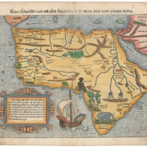
Africa Lybia Morenlandt mit Allen Künigreichen so zu unsern zeiten darin gefunden werden.
- $2,000
- A Seminal and Influential Early Map of Africa.
-
-
-
-
Add to cart
 Quick View
 - Africa
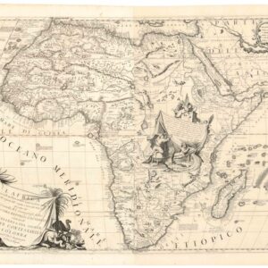
L’Africa Divisa nelle sue Parti secondo le piu moderne relationi colle scoperte dell’ Origine, e corso del Nilo.
- $3,200
- Coronelli’s majestic double-sheet map of Africa.
-
-
-
-
Add to cart
 Quick View
 - Africa
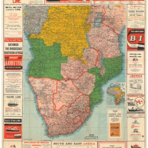
Map of Central and South Africa.
- $875
- A marvelous commercial edition of Stanford’s Map of Central and South Africa.
-
-
-
-
Add to cart
![[3-Sheet Biodiversity Map of Madagascar] Carte Internationale du Tapis Végétal et des Conditions Écologiques.](https://neatlinemaps.com/wp-content/uploads/2024/05/NL-01035-middle_thumbnail-300x300.jpg) Quick View
Quick View - Africa
[3-Sheet Biodiversity Map of Madagascar] Carte Internationale du Tapis Végétal et des Conditions Écologiques.
- $875
- A three-sheet map of one of Earth's biodiversity 'hot spots.'
-
-
