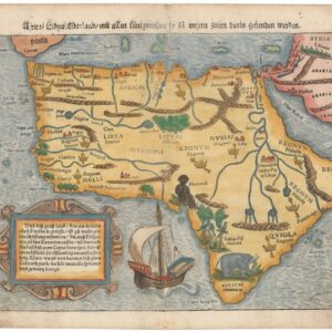
A landmark map for the historical cartography of Africa.
Africa Ioanne Baptista Nicolosio S.T.D. Sic Describente.
$4,400
1 in stock
Description
This spectacular four-sheet map of Africa — here a first state in rare original outline color — was produced by Italian geographer and map-maker Giovanni Battista Nicolosi on a commission from the Vatican. Published in Nicolosi’s seminal atlas Dell’ Ercole e Studio Geografico, the map tells the story of Europe on the cusp of an age of incredible and aggressive expansion. It is both one of the first post-Renaissance maps of Africa to be produced in the Italian schools of cartography, and the first map of Africa to use the landmark Nicolosi Globular Projection.
The most striking feature of the map is that Nicolosi chose to orient it with south at the top. Doing so was not uncommon in Italian maps of the preceding era, and indeed Nicolosi seems to have followed the example of 16th century Venetian cartographers such as Giovanni Battista Ramusio or Donato Bertelli, who also depicted Africa in this manner. In regard to content, however, the most direct source of inspiration were the maps of France’s royal cartographer, Nicolas Sanson. Sanson had published a similar map of Africa a decade prior to Nicolosi, and there is no doubt that the latter drew heavily from his predecessor when compiling his own chart. Yet despite drawing directly from Sanson’s map and postdating it by a decade, Nicolosi’s map (especially the first state as presented here) remained far more conservative in its geographic outlook than Sanson.
One of the ways in which this approach manifested itself was in the omission of important and relatively well-documented toponyms throughout Africa, especially in the interior. Omitting labels and ignoring recent travel accounts seems to have been a deliberate choice for Nicolosi, as much of this information would have been available to him through the immense Vatican archives. The insistence on such cartographic
conservatism was no doubt anchored in his educational background, which was strictly Catholic and informed by a Ptolemaic world-view. Yet despite his conservatism, it is also apparent that the maps of the Ercole were intrinsically connected to the rapid geographic leaps of the age.
Map Details
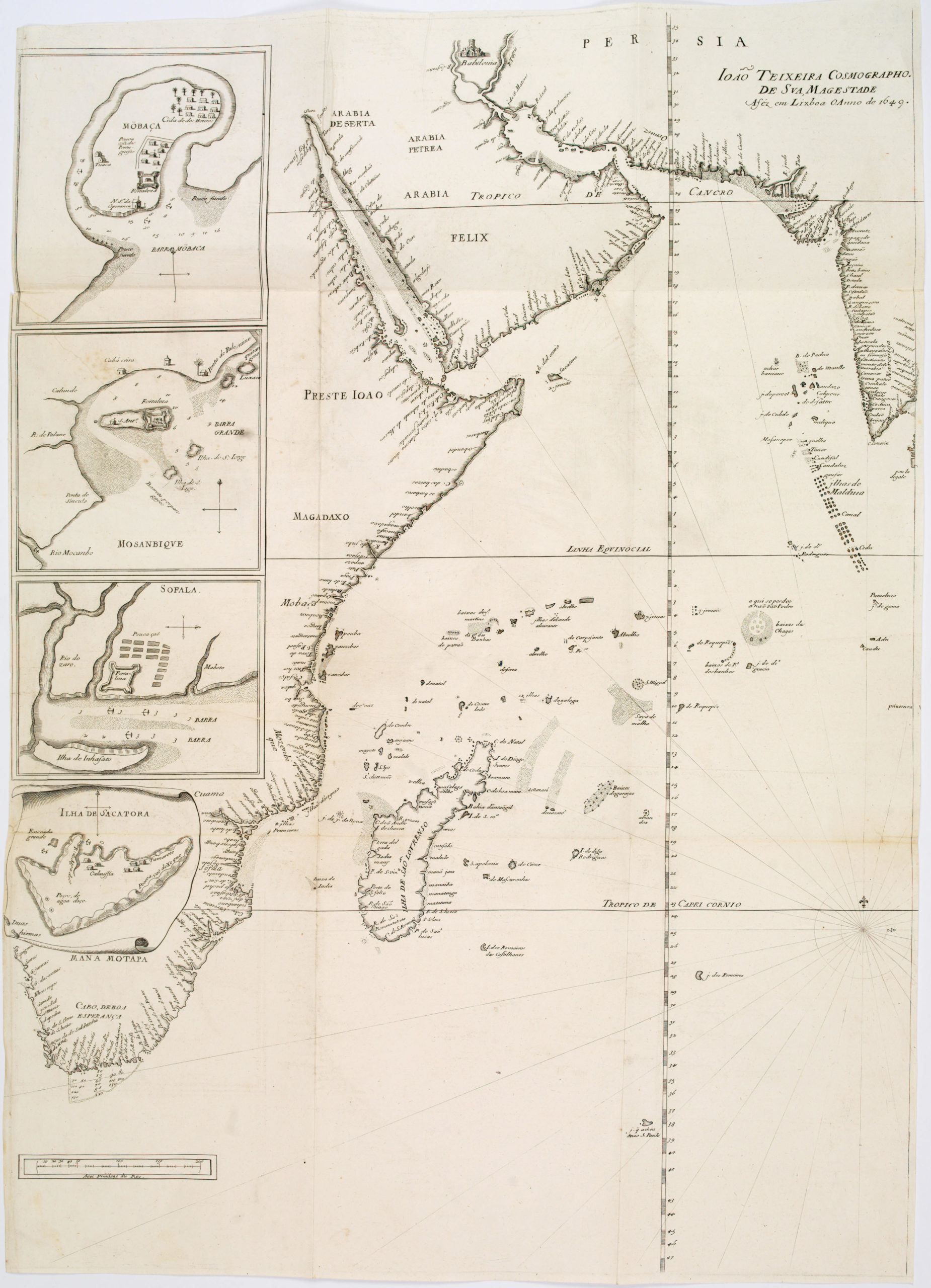
When the four sheets are combined, the map shows the entire outline of the continent, as well the important neighboring landmass of Arabia. In general, the map portrays quite clearly where and with whom the Europeans interacted at this stage, and reveals that the interior of the continent remained one of the world’s great unknowns in the 17th century. North Africa, the great river deltas, and the coasts are all relatively reliably rendered, whereas the interior still relies on myth, hear-say, and the occasional semi-reliable report from captains or traders sailing on the African coast and learning about the interior.
The island of Madagascar is included as a dominant feature on Sheet 1, but this was a part of the world that was heavily sailed upon by the Portuguese at this stage, so it is unsurprising that a Vatican cartographer could get his hands on some of the information that was coming back to Europe about these places. But like the rest of the map, the level of detail – especially in regard to place names – is noticeably limited when compared to for example Linschoten’s Itinerario map of the same region, which predates Nicolosi by more than sixty years. It seems Nicolosi recognized the paucity of toponyms and other geographic features when comparing his charts to his contemporaries, for when the second state was issued in 1671 — a year after Nicolosi’s death — a considerable number of new toponyms and features had been added to both Madagascar and the African continent as a whole. Yet even in the second state, the general outlook of the map remained conservative, underlining the kind of man and mapmaker that Nicolosi was. The cautious approach to new information — in particular evident in this, the first state of Nicolosi’s map — is one of the features that makes his output so highly prized among collectors.
Despite being known for his careful and conservative approach to mapping the world, there are also a number fo rather innovative features present on Nicolosi’s map of Africa. The idea of a great lake or internal sea from which the Nile originated was a notion that could be dated back to the days Ptolemy. Early Renaissance maps generally labeled this mythical lake Zaire Lacus, and more often than not would associate it with a range of equally mythical peaks known as the ‘Mountain of the Moon’ (Mons Lunae). Nicolosi departs from these old-school views and includes a new lake further east, which he labels Zaflan. This may well constitute a very early rendition of Lake Tana (the source of the Blue Nile), which probably was known by some intrepid Portuguese traders at this stage, but which was not formally discovered until the Scotsman James Bruce reached its southern shores more than a hundred years later.
Another large lake, found in the heart of the West Saharan Desert, is somewhat more dubious. Labeled Lacus Guarda, this enormous reservoir with a central island and several large settlements on its banks, is linked to the great Niger River. However, the rather comprehensive mapping of the Niger in this map predates the expeditions of Mungo Park by more than a century. At this stage, most new knowledge about this region came from sailors and traders who learned bits of information from their dealings along the coast. While these travelers were likely more familiar with inland routes and peoples, it remains entirely unclear who such sources constituted and how reliable they were. Regardless, it is quite apparent that both the rather straight east-west axis taken by the Niger River in this map, as well as the large central lake in the middle of it, are products of an over-invigorated European imagination.
The inclusion of the Zaflan and Guarda Lakes is nevertheless also an excellent example of the delicate balance and dichotomy present in this map. On one hand, Nicolosi’s compilation is characterized by skepticism and caution when its came to new sources of data; preferring to rely on antiquated geographic concepts as a safe fall-back position. On the other hand, as a Vatican cartographer, he had some of the latest travel accounts available to him, which allowed important innovations such as Lake Zaflan to be included without much fuss.
A final note should be made on the mysterious insert of France in the upper right corner of the joined map (Sheet 2). It is unclear why Nicolosi chose to insert a map of France here. The French had begun establishing their first African outposts in Senegal in 1624, but they were minor players with little to no colonial influence in Africa at this stage. This was a time in which all of France’s ‘international’ efforts were focused on securing their claim in America. The title of the insert is not helpful either, as it simply states (roughly translated from Latin): “FRANCE. In an attempt to describe it ten parliaments” (i.e., regions).
Nicolosi and the Dell’ Ercole e Studio Geografico
Giovanni Battista Nicolosi (1610-1670) was a Sicilian priest and cartographer working for the Vatican in Rome. Motivated by the ground-breaking maps of French cartographer Nicolas Sanson (especially those in his 1653 Index Geographicus), the Propaganda Fide of Rome commissioned Nicolosi to produce an atlas that could rival Sanson’s. Over the next seven years, Nicolosi labored intensively to meet his employer’s demand, and the outcome would be one of the most essential Italian atlases produced in the 17th century.
Nicolosi’s Dell’ Ercole e Studio Geografico was published in Rome in 1660 and again in 1671 as a posthumous Latin edition. The title referred to a comparison between the labors of Hercules and those he had sustained to complete a full description of the earth. In the Ercole, Nicolosi presented large four-sheet maps of all the continents as they were known in the 1650s (Africa, North America, South America, Europe, and Asia – twenty-two plates in all). The atlas also contained an essential double map of the world, which incorporated many of the continental map innovations on a global scale (e.g., both the dubious depiction of the Niger River, as well as the first relatively accurate inclusion of the Rio Grande). Consequently, both the 4-sheet maps of the continents and the two-sheet map of the world have become highly sought after by collectors and institutions alike.
The Ercole was dedicated to Giovanni Battista Borghese and consisted of two folio volumes printed by Vitale Mascardi. Composed of no less than 22 maps with associated explanatory text, the Latin edition of the Ercole (1670) allowed Nicolosi’s ideas to be fully integrated into the cartographic mindset of Europe. In time, the Ercole became one of the most critical geographical works of the 17th century. This was partly because of the incredible archives and sources available to Vatican scholars in the 17th century. Still, the main reason was that Nicolosi approached global mapping in a novel way. He combined the traditions and perspectives of 16th-century Roman and Venetian mapmakers with the latest approaches of contemporary greats such as Nicolas Sanson. This amalgamation of traditions and styles meant that Nicolosi could come up with an entirely new way of portraying the world – especially when it came to larger landmasses where the curvature of the Earth affected how such terrain could be portrayed correctly.
Nicolosi was the first to employ the so-called pseudo-perspective projection in which the established meridians were perfected by complimenting circular parallels. Over the following decades, and especially during the early 18th century, this projection technique – also known as the globular projection – became increasingly popular and was applied by seminal cartographers such as Guillaume de l’Isle and Aaron Arrowsmith. In the decades after Nicolosi’s death, the globular or Nicolosi projection replaced the stereographic projection popularized by Mercator, which had increasingly fallen into disuse. During the 19th century, the Nicolosi perspective became the standard cartographic projection technique, and it remains in use today.
Cartographer(s):
Giovanni Battista Nicolosi (1610-1670), also known as Giovan Battista, was a Sicilian priest, geographer, and cartographer who worked for the Vatican’s Congregation for the Evangelization of Peoples (or Propaganda Fide) under Pope Gregory XV. Officially, the Fide office was established to promote missionary work across the globe. Still, the reality was that it constituted an essential office for the maintenance and dilation of the Church’s power in an ever-expanding world.
Arriving in the papal capital around 1640, Nicolosi studied letters, sciences, geography, and languages. In 1642, he published his Theory of the Terrestrial Globe, a small treatise on mathematical geography, and a few years later, his guide to geographic study was issued, a short treatise on cosmography and cartography. Both works reflected a Ptolemaic worldview, but his guide to geographic analysis would soon serve as an introduction to Nicolosi’s real magnum opus, Dell’ Ercole e Studio Geografico, first published in 1660. On the other hand, his Theory of the Terrestrial Globe brought Nicolosi to the attention of broader scientific circles. It earned him the Chair of Geography at the University of Rome. In late 1645, he traveled to Germany at the invitation of Ferdinand Maximilian of Baden-Baden, where he remained for several years until he returned to Rome. Here, Nicolosi was appointed chaplain of the Borghesiana in the Basilica of Santa Maria Maggiore. This honor was conferred on him by Prince Giovanni Battista Borghese, whom Nicolosi had tutored and in whose palace he had lived since 1651. Years later, Nicolosi would thank the prince for his generosity by dedicating his most seminal work to him.
A considerable collection of Nicolosi’s unpublished work exists in the Vatican and other national archives. This includes a large chorographic (i.e. descriptive) map of all of Christendom, commissioned by Pope Alexander VII, and a full geographic description and map of the Kingdom of Naples, which was sent to Habsburg Emperor Leopold I in 1654.
Condition Description
Very good. 4 sheets, can be joined on request.
References

![[3-Sheet Biodiversity Map of Madagascar] Carte Internationale du Tapis Végétal et des Conditions Écologiques.](https://neatlinemaps.com/wp-content/uploads/2024/05/NL-01035-middle_thumbnail-300x300.jpg)