-
-
Add to cart
 Quick View
 - Egypt, Middle East - Holy Land Maps
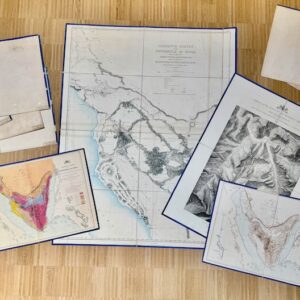
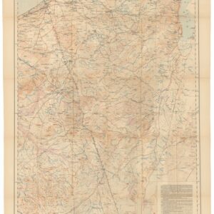
Ordnance Survey of the Peninsula of Sinai. Charles William Wilson and Henry Spencer Palmer. Southampton: Ordnance Survey Office, 1869–1870. Maps, Plans and Sections.
- $5,500
- Where Exodus Happened: 1869–1870 Complete Ten Map Portfolio of the Ordnance Survey of the Peninsula of Sinai.
-
-
-
-
Add to cart

 Quick View
 - Bird's-eye-views, Eastern Mediterranean - Holy Land
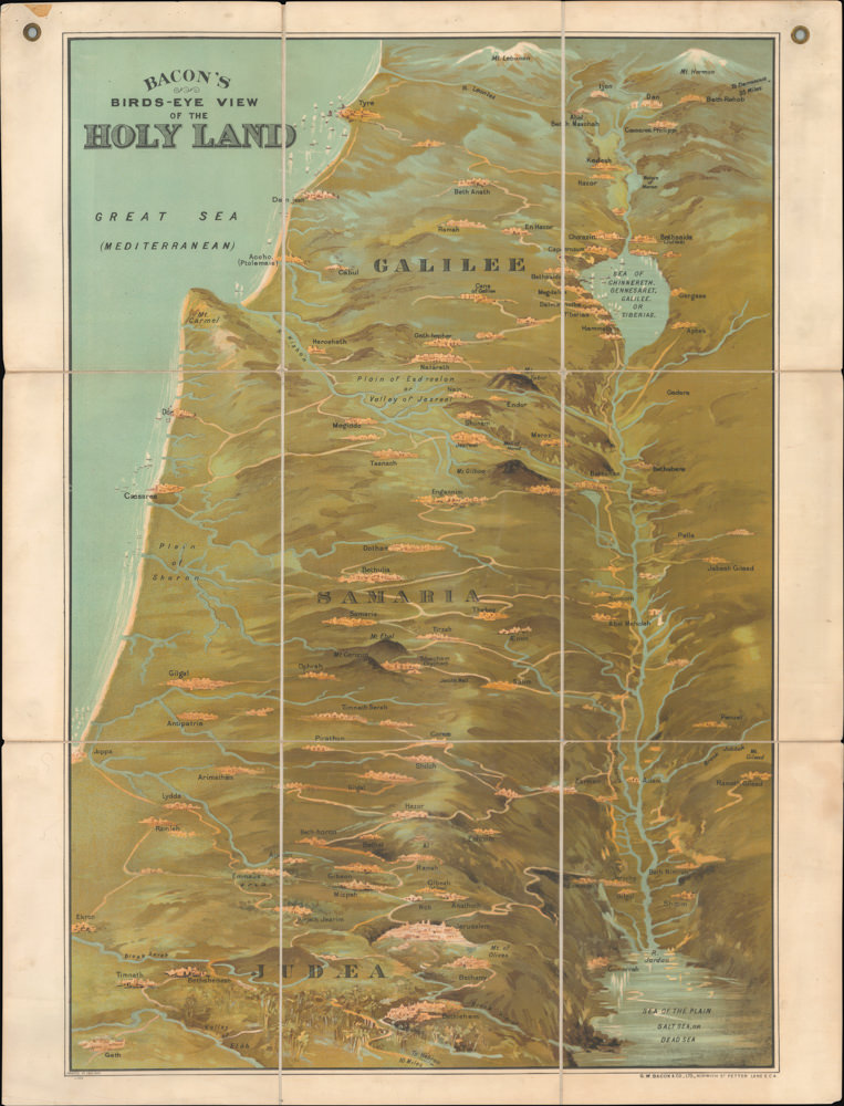
Bacon’s Bird’s-Eye View of the Holy Land.
- $1,800
- George Washington Bacon’s iconic bird’s-eye-view of the Holy Land.
-
-
-
-
-
Add to cart
 Quick View
 - Eastern Mediterranean - Holy Land, Middle East - Holy Land Maps
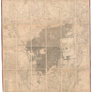
Ordnance Survey of Jerusalem By Captain Charles W. Wilson R.E. Under The Direction of Colonel Sir Henry James, R.E. F.R.S. & C. Director of the Ordnance Survey. 1864-5.
- $3,500
- 1865 British Survey of Jerusalem: the First Scientific Mapping of the City and its Environs.
-
-
-
-
Add to cart
 Quick View
 - Arabia and the Red Sea, Middle East - Holy Land Maps
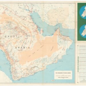
Saudi Arabian Road Map / خارطة طريق المملكة العربية السعودية
- $900
- 1973 Aramco Bilingual Road Map of the Arabian Peninsula.
-
-
-
-
Add to cart
 Quick View
 - Eastern Mediterranean - Holy Land, Middle East - Holy Land Maps
The Negeb or Desert south of Beersheba.
- $425
- 1921 War Office Map of the Negev, Based on the 1913–1914 Woolley-Lawrence-Newcombe Survey.
-
-
-
-
Add to cart
![Emigranter till det nya Jerusalem, Frälsarens Kungliga Linie [Emigrants to the New Jerusalem, the Savior’s Royal Line].](https://neatlinemaps.com/wp-content/uploads/2026/04/NL-02567_thumbnail-300x300.jpg) Quick View
Quick View - Curiosities - Miscellanea, Eastern Mediterranean - Holy Land, Middle East - Holy Land Maps
Emigranter till det nya Jerusalem, Frälsarens Kungliga Linie [Emigrants to the New Jerusalem, the Savior’s Royal Line].
- $975
- 1902 circa Swedish Allegorical Broadside — Emigrants to the New Jerusalem.
-
-
-
-
Add to cart
![ОБЩІЙ ВИДЪ СВ. ГРАДА ІЕРУСАЛИМА [General View of the Holy City of Jerusalem].](https://neatlinemaps.com/wp-content/uploads/2026/02/NL-02492_thumbnail-300x300.jpg) Quick View
Quick View - Middle East - Holy Land Maps, Eastern Mediterranean - Holy Land
ОБЩІЙ ВИДЪ СВ. ГРАДА ІЕРУСАЛИМА [General View of the Holy City of Jerusalem].
- $3,200
- A brilliantly colored panoramic view of Ottoman Jerusalem, designed for Russian Orthodox pilgrims.
-
-
-
-
Add to cart
 Quick View
 - Iran - Persia - Central Asia, Middle East - Holy Land Maps
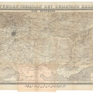
Tehran Shemiran Rey Demavand Karaj and Environs.
- $675
- Rare first state of Abbas Sahab’s iconic map of Tehran and Environs.
-
-
-
-
Add to cart
 Quick View
 - Middle East - Holy Land Maps, Eastern Mediterranean - Holy Land, Atlases & Books
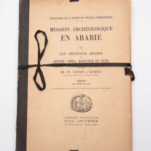
Mission Archéologique en ARABIE III: Les châteaux arabes.
- $375
- Jaussen & Savignac’s iconic plate atlas of Islamic desert architecture.
-
-
-
-
Add to cart
 Quick View
 - Eastern Mediterranean - Holy Land, Pictorial maps
Palestine in Third Dimension.
- $975
- A Spectacular World War II-era View of the Holy Land.
-
-
-
-
Add to cart
 Quick View
 - Arabia and the Red Sea, Middle East - Holy Land Maps
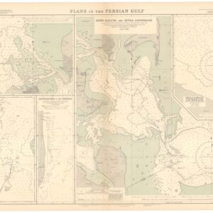
British Admiralty Chart No. 3789. Plans in the Persian Gulf.
- $2,400
- A British Admiralty map of the Persian Gulf, created at the dawn of Arabia’s emergent oil industry.
-
-
-
-
Add to cart

 Quick View
 - Africa, Arabia and the Red Sea, Asia, India
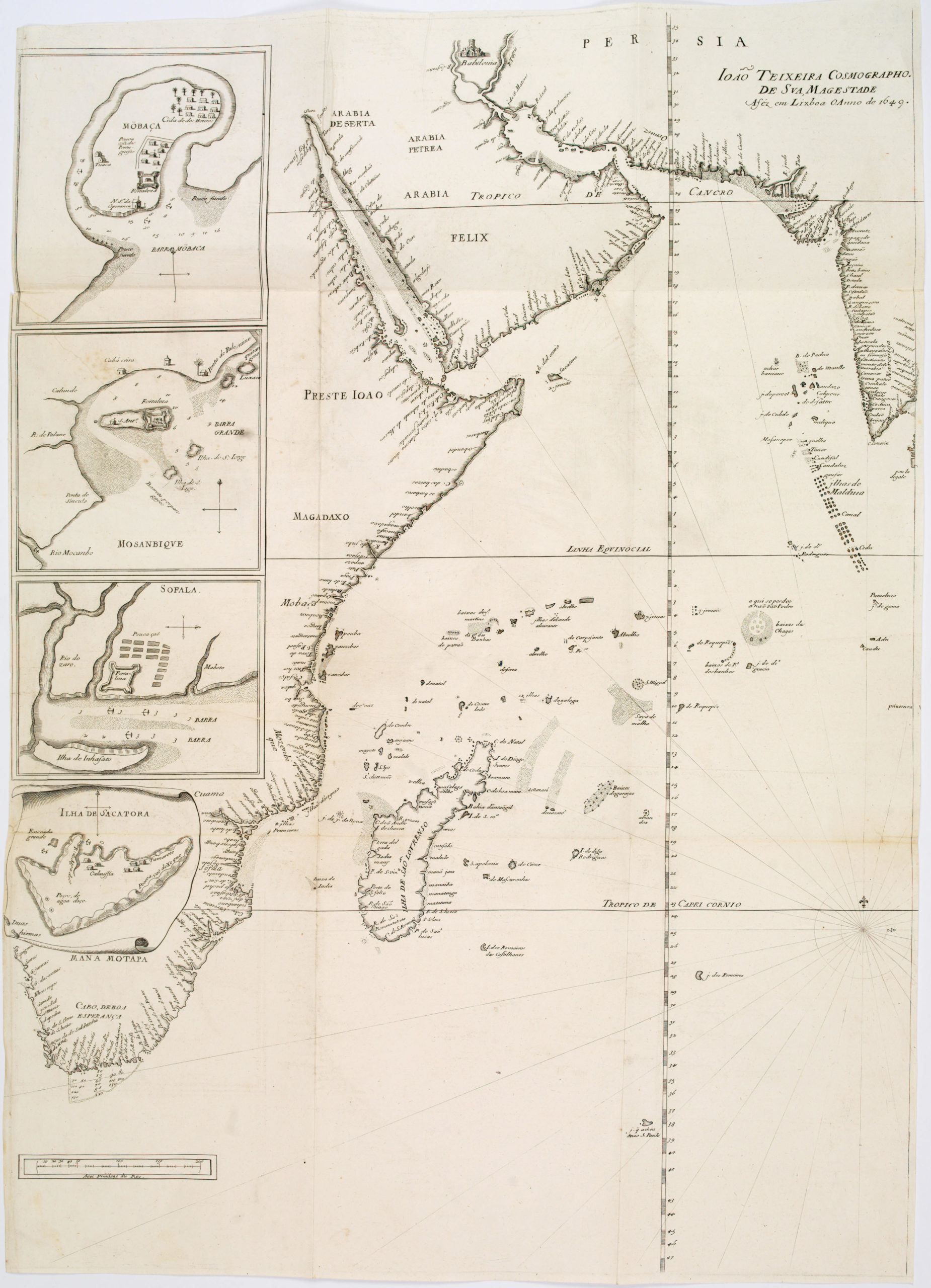
João Teixeira Cosmographo. De sua, Magestade. Aféz em Lixboa o Anno de 1649
- $4,200
- Rare 17th century portolan-style chart designed for use aboard Portuguese merchant vessels.
-
-
-
