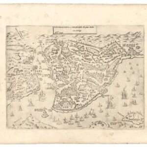
A pair of plans of Istanbul made for Ottoman Sultan Abdul Aziz.
Plan der Stadt Constantinopel nebst deren nächsten Angrenzungen.
$1,200
In stock
Description
A rare German plan of Constantinople/Istanbul in two identical yet highly distinct editions. One is a black and white printing on wax paper, whereas the other is a chromolithograph on paper. The plan was compiled by a Prussian officer, Carl Stolpe, who traveled to the Ottoman capital after leaving the German Army’s Engineering Corps to the Ottoman capital, where he gained employment as a surveyor and mapmaker under Sultan Abdul Aziz (r. 1861-1876).
The map shows the confluence of the Golden Horn, Bosphorus, and Sea of Marmara. In the center of the composition is the heart of old Constantinople, generally referred to as Sultanahmet, and across the Golden Horn, we see the old Genoese colony area known as Galata. The highly detailed map offers many historical sites and a meticulous rendition of the organic flurry of streets that zig-zag through the old city.
The tri-lingual city plan has toponymic labels in Ottoman Turkish, German, and French. In the upper right corner, just beyond the Tershane district, we find a symbolic legend denoting the different denominal neighborhoods of the city (red for Muslim, black for Christian, and yellow for Jewish). Next to the legend is an elaborate Islamic calligraphy, the tugra or ceremonial signature of the Ottoman Sultan.
While this map was compiled in the mid to late 1860s, Neatline’s examples were reprinted during the Great War in 1917, as indicated at the bottom right corner. The original came from the General Quartermaster’s office within the still autonomous Ottoman capital. In other words, it is both a wartime printing and a manifestation of the unholy alliance between the Ottomans and the German Reich. The First World War would be the final contributing factor to the collapse of the Ottoman Empire, and this map has thus been seen as one of its last cartographic creations.
Even though it is unclear what the exact purpose of the black and white wax paper edition is, wax paper was a common method of replicating a print without much need for printing equipment. Another common use of wax paper was to transfer an image to a hard surface such as plywood.
Context is Everything
In the latter half of the 19th century, printed maps of Istanbul became increasingly popular. Many maps were designed to be travel guides for the growing number of European tourists visiting the Ottoman capital. During the 1860s, Carl Stolpe was one of several non-Turkish mapmakers operating from Istanbul to respond to this demand. Most of Stolpe’s maps were published locally by Lorentz & Otto Keil, and they often featured explanatory texts providing information about the historical sites within the city in both French and German.
Stolpe’s maps enjoyed considerable success, seeing multiple editions published until the close of the 19th century. The later editions included blue lines to indicate the railway networks, but these do not feature on the examples offered by Neatline, suggesting that the original state was reprinted in this case.
The German Reich cultivated close diplomatic and military ties with the Ottoman Empire during the final decades of the 19th century and up until World War I. This plan can be seen as a symptom or reflection of that relationship in many ways.
Cartographer(s):
Carl Stolpe was a Prussian army engineer who, during the 1860s, found employment under the Ottoman Sultan Abdul Aziz in Istanbul. He produced several city plans, which were published in Istanbul.
Condition Description
Some minor spotting and wear along margins. Soft folds.
References