NEAR MINT and VG+: A VG+ record should sound the same as a near mint record. There should be no surface noise whatsoever in either grade. The difference between Near Mint and VG+ is extremely minor cosmetic defects that do not affect play.
-
-
Add to cart
![Nova Totivs Evropae Tabvla, ex magnis Gerardi de Iudaeis P[atris] desumpta…](https://neatlinemaps.com/wp-content/uploads/2026/07/NL-02707_thumbnail-300x300.jpg) Quick View
Quick View - Europe
Nova Totivs Evropae Tabvla, ex magnis Gerardi de Iudaeis P[atris] desumpta…
- $9,400
- Phantom Islands in the Atlantic and Twenty Costume Figures: De Jode's Rare 1593 Map of Europe in Excellent Original Color.
-
-
-
-
Add to cart
 Quick View
 - Pictorial maps, San Francisco
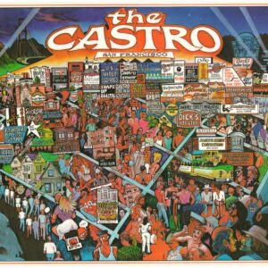
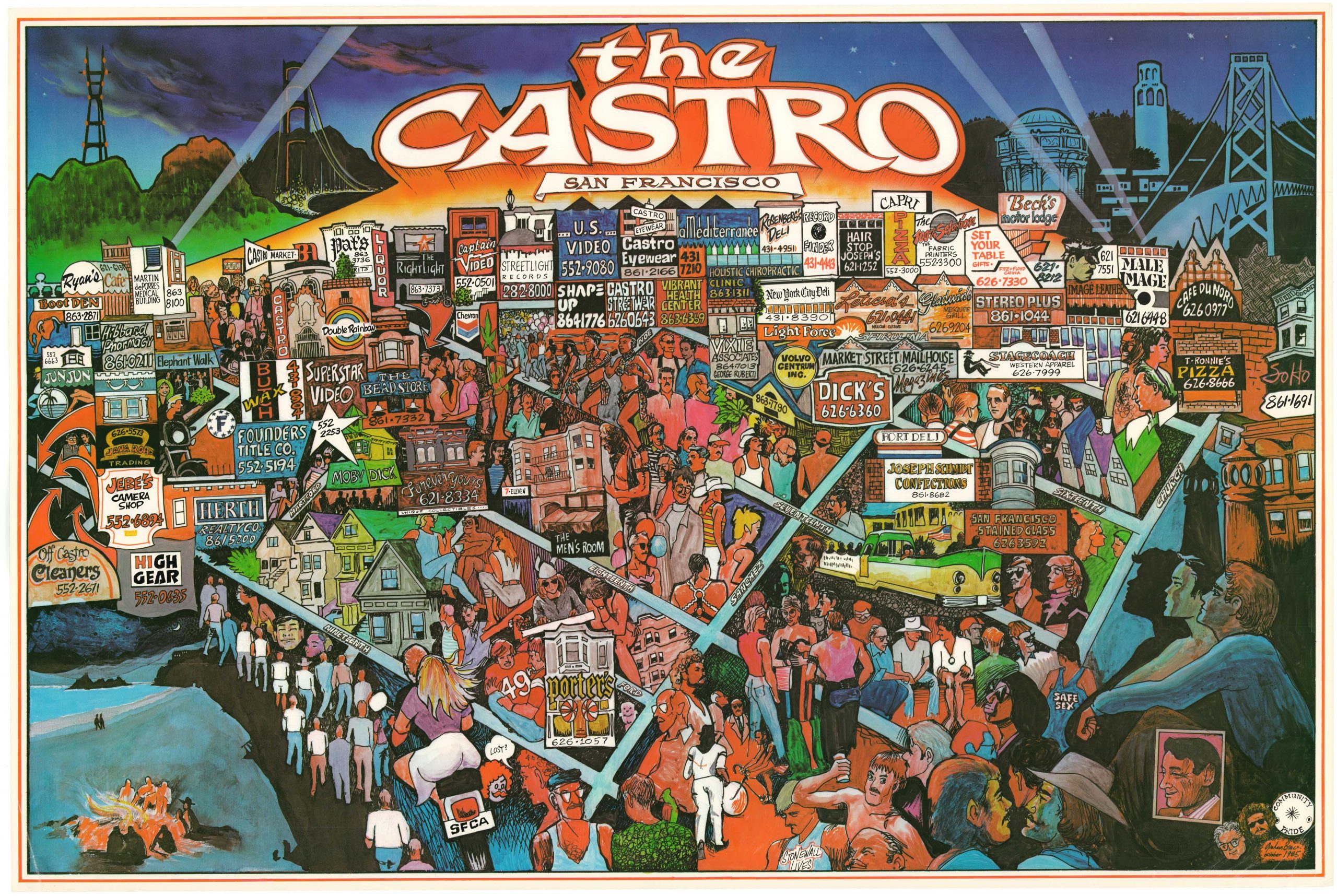
The Castro, San Francisco
- $1,800
- A rare poster map of unknown origin depicting San Francisco’s iconic Castro District in the mid-1980s.
-
-
-
-
-
Add to cart
![[La Nuova Topografia di Roma] — Piazza del Popolo, the Spanish Steps, and the Villa Borghese.](https://neatlinemaps.com/wp-content/uploads/2026/07/NL-02640_thumbnail-300x300.jpg) Quick View
Quick View - Europe, Italy
[La Nuova Topografia di Roma] — Piazza del Popolo, the Spanish Steps, and the Villa Borghese.
- $1,600
- The Grand Tour's First View of Rome, from the Gate to the Steps.
-
-
-
-
Add to cart
![[La Nuova Topografia di Roma] — The Vatican, St. Peter’s Basilica, and Castel Sant’Angelo.](https://neatlinemaps.com/wp-content/uploads/2026/07/NL-02639_thumbnail-300x300.jpg) Quick View
Quick View - Europe, Italy
[La Nuova Topografia di Roma] — The Vatican, St. Peter’s Basilica, and Castel Sant’Angelo.
- $1,800
- Rome's Most Sacred Quarter, from One of the Greatest Urban Maps Ever Made.
-
-
-
-
Add to cart
 Quick View
 - Asia, India, Southeast Asia & Australia
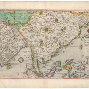
Tertiae Partis Asiae quae modernis India orientalis dicitur acurata delineatio Autore Iacobo Castaldo Pedemontano.
- $9,500
- De Jode’s 1593 seminal map of Asia in splendid original color.
-
-
-
-
Add to cart
 Quick View
 - United States
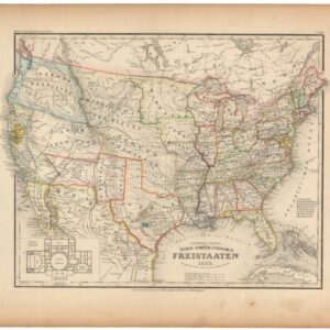
General-Karte der Nord-Amerikanischen Freistaaten.
- $675
- 1853 Map of the United States from Meyer's Atlas, with Capitol Inset — One Year Before the Kansas-Nebraska Act.
-
-
-
-
Add to cart
![[The Antlers Hotel, Colorado Springs].](https://neatlinemaps.com/wp-content/uploads/2026/07/NL-02730_thumbnail-300x300.jpg) Quick View
Quick View - Texas and The West, United States
[The Antlers Hotel, Colorado Springs].
- 1901 Photochrom Print of the Second Antlers Hotel, Colorado Springs, with Pikes Peak in the Background.
-
-
-
-
Add to cart
 Quick View
 - United States
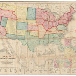
Military Map of the United States & Territories Showing the Location of the Military Posts, Arsenals, Navy Yards, & Ports of Entry.
- 1861 Civil War Map Showing Arizona as a Confederate Territory, and Among the First Maps to Show the Three New Territories of Colorado, Dakota, and Nevada.
-
-
-
-
Add to cart
 Quick View
 - Asia, Southeast Asia & Australia
แผนที่ประเทศไทย / MAP OF THAILAND
- $3,000
- Unrecorded 1958 Wall Map of Thailand Compiled from Royal Thai Army, Government, and French Indochinese Sources, Published in the Year of the Coup.
-
-
-
-
Add to cart
 Quick View
 - India
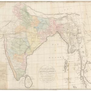
A New and Improved Map of Hindoostan.
- $3,600
- First map of India published in India?
-
-
-
-
Add to cart
 Quick View
 - Texas and The West
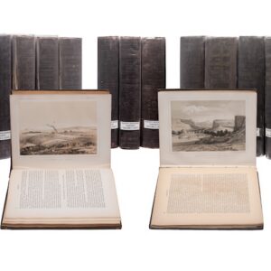
PACIFIC RAILROAD SURVEYS. Reports of Explorations and Surveys, to Ascertain the Most Practicable and Economical Route for a Railroad from the Mississippi River to the Pacific Ocean, Made Under the Direction of the Secretary of War, in 1853-4. Washington, D.C.: Beverley Tucker, 1855-1861.
- $6,000
- The Complete Pacific Railroad Surveys, Senate Issue, 1855–1861.
-
-
-
-
Add to cart
 Quick View
 - United States
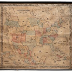
Colton’s Map of the United States of America, The British Provinces, Mexico and The West Indies Showing the Country from the Atlantic to the Pacific Ocean. New York, 1855.
- $3,800
- Colton's 1855 Wall Map of the United States: The Rarest Known State, and the First to Show Gadsden Purchase Borders.
-
-