-
-
Add to cart
- Eastern Mediterranean - Holy Land, Pictorial maps, Wall maps
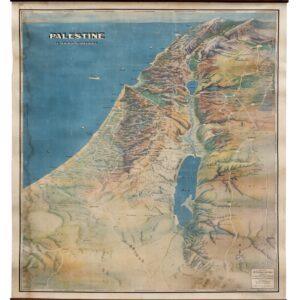
Palestine in Third Dimension.
- $1,600
- A Spectacular World War II-era View of the Holy Land.
-
-
-
-
Add to cart

- North America, Wall maps
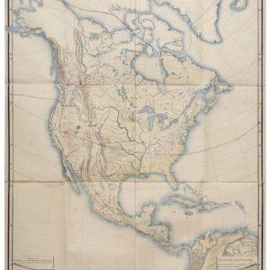
Nord-Amerika.
- $1,900
- Von Sydow’s geophysical wall map of North America.
-
-
-
-
Add to cart

- Marin, Sonoma, & Napa Valley, Wall maps
Official Map of Marin County, California 1892 Compiled from Records and Surveys.
- $8,500
- Dodge's monumental 1892 wall map of Marin County: the greatest Marin map ever made.
-
-
-
-
Add to cart
- North America, Wall maps
Nord-Amerika.
- $1,900
- Von Sydow’s geophysical wall map of North America.
-
-
-
-
Add to cart

- Eastern United States, Wall maps
Road and Property Map showing the Towns of Stamford and Greenwich Conn. Together with Surrounding Territory Compiled from Actual Surveys, Private Plans & Official Records…
- $24,500
- The greatest and most impressive 19th-century map of Connecticut.
-
-
-
-
Add to cart
- Eastern United States, Featured Maps & Views, Wall maps
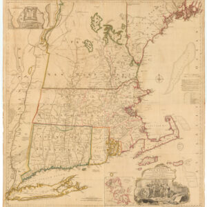
A MAP of the most INHABITED part of NEW ENGLAND, containing the PROVINCES of MASSACHUSETS BAY and NEW HAMPSHIRE, with the COLONIES of KONEKTIKUT AND RHODE ISLAND. Divided into Counties and Townships: The whole composed of Actual Surveys and its situation adjusted by ASTRONOMICAL OBSERVATIONS.
- $59,000
- One of the greatest maps of New England ever made.
-
-
-
-
-
Add to cart

- Mexico - Central & South America, Railroad Maps, Wall maps
República Argentina / Ministerio de Obras Publicas / Red de ferrocarriles en la fecha del centenario / Confeccionado con los dalos obtenidos por la dirección general de ferrocarriles…
- $1,600
- A fabulous large-format official Ministry of Public Works 1910 railroad map of Argentina.
-
-
-
-
-
Add to cart

- Eastern Mediterranean - Holy Land, Wall maps
Map of Western Palestine from surveys conducted for The Committee of the Palestine Exploration Fund. By Lieuts. C. R. Conder and H. H. Kitchener, R. E. Reduced from the one inch map in twenty six sheets. Special Edition Illustrating The New Testament also The Talmud and Josephus (after the birth of Jesus)…
- $1,000
- Special edition 1882 New Testament-themed map of Western Palestine.
-
-
-
-
-
Add to cart
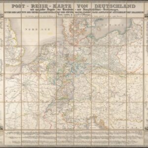
- Germany & the Netherlands, Wall maps
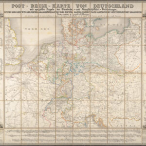
Post-Reise-Karte von Deutschland mit spezieller Angabe der Eisenbahn- und Dampfschiffahrt-Verbindungen, unter der Leitung der Generaladministration der Königl. Bayer. Posten nach amtlichen Mittheilungen bearbeitet. Carte routi’ere et postale de l’Allemagne.
- $650
- A large-format 1843 post-road and transportation map of the German Confederation.
-
-
-