A marvelous commercial edition of Stanford’s Map of Central and South Africa.
Map of Central and South Africa.
$875
1 in stock
Description
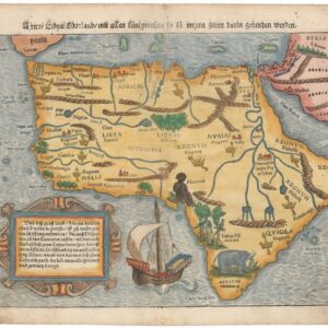
This gorgeous map of colonial Central and South Africa was licensed by the British mapmaking company Stanford to be used for commercial reproduction in the London-based publication South Africa (an image of the magazine is shown in the lower right corner). The company’s founder, Edward Stanford, originally compiled the map but it had since been updated by the firm to correspond to contemporary reality.
The map depicts the southern half of the African continent, spanning from Uganda and the Congo River in the north to Cape Town and Port Elisabeth at the continent’s southern tip. The map is a product of the final years of European colonialism in Africa and is subdivided into nationalized colonies. Their respective affiliation is seen in the bright coloration: pink for British holdings, green for Portuguese holdings, and yellow for Belgian Congo. Red lines further subdivide the British territories into various colonial states and protectorates. From north to south, these are Uganda, Kenya, Tanganyika, Northern Rhodesia, Nyasland, Southern Rhodesia, Bechuanaland, South-West Africa, Transvaal, Swaziland, Orange Free State, Basutoland, (KwaZulu-) Natal, and the Cape of Good Hope. Portuguese holdings consist of Mozambique and Angola (Portuguese West Africa).
The map is highly detailed, with toponymy and cartographic keys and symbols printed densely throughout the map. In addition to showing and naming countless rivers, regions, and settlements, the map includes all the operating railroad stretches. Within a decade of its publication, the political geography of Central and Southern Africa would change entirely and irrevocably following the end of colonialism. Our map is a cartographic snapshot of the time just before that critical upheaval.
A final note should be made on the commercial framing. Having been reproduced to aid people contemplating travel to Africa, Stanford’s map is surrounded on all four sides by era-specific advertisements pertaining to such a grand adventure. The companies include travel and tourism agencies, ocean liners, and cargo freight businesses. In unison, they provide an atmospheric addition to an already splendid map.
Cartographer(s):
Edward Stanford (1827-1904) was a prominent British cartographer and entrepreneur who founded Stanford’s, a map-selling business that became one of the most significant map publishing companies in the 19th and 20th centuries. Established in 1853, his London-based shop was renowned for its extensive range of topographic and thematic maps.
Stanford’s attention to detail and dedication to producing accurate, up-to-date maps made his firm the official map supplier to the British government during several notable expeditions. In addition to supplying explorers, the general public, and various institutions with reliable maps, Stanford’s legacy also includes the notable “Stanford’s Library Map of London and its Suburbs,” which was acclaimed for its precision. The brand he founded remains respected in the cartographic world and has also expanded into travel books and accessories.
Condition Description
Minor wear and soft folds.
References
![[3-Sheet Biodiversity Map of Madagascar] Carte Internationale du Tapis Végétal et des Conditions Écologiques.](https://neatlinemaps.com/wp-content/uploads/2024/05/NL-01035-middle_thumbnail-300x300.jpg)

![[South Africa] Photograph panorama of Cape Town, c. 1870](https://neatlinemaps.com/wp-content/uploads/2022/09/Screen-Shot-2022-12-18-at-11.22.15-AM-300x300.png)