Nautical chart of Mexico, including San Diego and the Texas coast.
Carte de la côte occidentale d’Amérique…
$875
1 in stock
Description
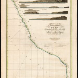
This authentic antique map, originally dating to the height of the Civil War, showcases the western coast of Mexico and Baja California, spanning from Tehuantepec in the south to San Diego in the north. Also depicted is the eastern coast along the Gulf of Mexico, including the entire Texas coastline.
The map shows a detailed nautical cartography, which highlights specific areas of maritime interest along the coast. While essentially a French sea chart of Mexico’s coastline, this map has far more to offer its viewers than a mere littoral view. Notably, the map includes essential navigational details such as seabed topography and extensive depth soundings, seabed declinations and shoals, and crucial coastal features such as inlets, naval docks, and lighthouses (demarcated with swathes of yellow along the coast).
Our example also includes hand-written annotations in red, denoting the daily positions of a vessel coming in from the south and tacking its way north-northeast, until finally landing at the Punta dos Pescadores on the southern tip of Baja California. En route, indicated some five measurements before the landing, this vessel encountered a cyclone, which was marked on the map.
Although the specific mapmaker remains unknown, this large chart provides a comprehensive view of the entire region, including all of Baja California, which at the time was still referred to as Old California. The map was meticulously crafted based on the latest geographical information and initially published in 1863 under the ministry of Chasseloup-Laubat, by order of the Emperor. A corrected edition was released in 1887. The venue for this publication was the renowned Dépôt des cartes et plans de la Marine.
This gorgeous nautical chart is generally scarce on the market, and Neatline’s example of it is in excellent condition and original color, making it a valuable piece of historical cartography from the height of the Civil War.
Census
Examples of this map are scarce ON the market, as well as in institutional collections. The French Naval Ministry obviously has copies, as will the French National Library (although this is not registered independently in OCLC). The OCLC lists only two institutional copies of the 1863 edition of this map: one at Cambridge, the other at the University of Wisconsin – Milwaukee (OCLC no. 47987403).
Cartographer(s):
The Dépôt de la Marine, officially the Dépôt des cartes et plans de la Marine, served as France’s central institution for chart-making and hydrography. Established in 1661, the initial steps towards centralizing hydrography included the inauguration of the Royal School of Hydrography and the first survey of France’s coasts (1670-1689). By 1680, a number of essential chart collections constituted the base collection of the Dépôt.
Functioning as the central repository of charts for the French Navy, the Dépôt soon evolved. In 1720, it merged with government archives covering the colonies, becoming an even more comprehensive repository of nautical knowledge. From 1737, the Dépôt began producing its own original charts, and by 1750, it actively participated in scientific expeditions to map distant shores and enhance longitude calculations.
In 1773, the Dépôt gained a monopoly over the production and distribution of maritime materials. Dépôt-approved charts, created by esteemed mapmakers like Philippe Bauche, Jacques-Nicolas Bellin, Rigobert Bonne, Jean Nicolas Buache, and Charles-François Beautemps-Beaupré, were of the highest quality and distributed to officials in port cities across France. The charts were also sold by authorized dealers. In 1886, the Dépôt was transformed into the Naval Hydrographic Service., which in turn became the Naval and Oceanographic Service (SHOM) in 1971.
Despite these changes, the fundamental purpose of providing high-quality cartographic and scientific information to France’s navy and merchant marines remained. The historical archives of the Dépôt were transferred to the Bibliothéque national de France in the 1990s.
Condition Description
Wear along edge. Thick paper. Watermark for Service Hydrographique in bottom margin. Hand-written annotations tracking the course of a ship in the Pacific.
References