The Dépôt de la Marine, officially the Dépôt des cartes et plans de la Marine, served as France’s central institution for chart-making and hydrography. Established in 1661, the initial steps towards centralizing hydrography included the inauguration of the Royal School of Hydrography and the first survey of France’s coasts (1670-1689). By 1680, a number of essential chart collections constituted the base collection of the Dépôt.
Functioning as the central repository of charts for the French Navy, the Dépôt soon evolved. In 1720, it merged with government archives covering the colonies, becoming an even more comprehensive repository of nautical knowledge. From 1737, the Dépôt began producing its own original charts, and by 1750, it actively participated in scientific expeditions to map distant shores and enhance longitude calculations.
In 1773, the Dépôt gained a monopoly over the production and distribution of maritime materials. Dépôt-approved charts, created by esteemed mapmakers like Philippe Bauche, Jacques-Nicolas Bellin, Rigobert Bonne, Jean Nicolas Buache, and Charles-François Beautemps-Beaupré, were of the highest quality and distributed to officials in port cities across France. The charts were also sold by authorized dealers. In 1886, the Dépôt was transformed into the Naval Hydrographic Service., which in turn became the Naval and Oceanographic Service (SHOM) in 1971.
Despite these changes, the fundamental purpose of providing high-quality cartographic and scientific information to France’s navy and merchant marines remained. The historical archives of the Dépôt were transferred to the Bibliothéque national de France in the 1990s.
-
-
Add to cart
 Quick View
 - Americas, Mexico - Central & South America, Texas and The West
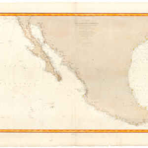
Carte de la côte occidentale d’Amérique…
- $875
- Nautical chart of Mexico, including San Diego and the Texas coast.
-
-
Archived
- Out of Stock
![[American Revolution] Neptune Americo-Septentrional contenant les Cotes, Îles et Bancs, les Baies, Ports, et Mouillages, et les Sondes des Mers de cette partie du Monde, depuis le Groenland inclusivement, jusques et compris le Golfe du Mexique avec les Îles de Sous-le-Vent et du Vent, accompagné de Plans particuliers des Ports les plus fréquentés.](https://neatlinemaps.com/wp-content/uploads/2024/05/NL-02107-1_thumbnail-300x300.jpg)
- Atlases & Books
[American Revolution] Neptune Americo-Septentrional contenant les Cotes, Îles et Bancs, les Baies, Ports, et Mouillages, et les Sondes des Mers de cette partie du Monde, depuis le Groenland inclusivement, jusques et compris le Golfe du Mexique avec les Îles de Sous-le-Vent et du Vent, accompagné de Plans particuliers des Ports les plus fréquentés.
- A nearly flawless first edition of the French Navy's official atlas of American coasts during the Revolutionary War.
- Read moreQuick View
-