A nearly flawless first edition of the French Navy’s official atlas of American coasts during the Revolutionary War.
[American Revolution] Neptune Americo-Septentrional contenant les Cotes, Îles et Bancs, les Baies, Ports, et Mouillages, et les Sondes des Mers de cette partie du Monde, depuis le Groenland inclusivement, jusques et compris le Golfe du Mexique avec les Îles de Sous-le-Vent et du Vent, accompagné de Plans particuliers des Ports les plus fréquentés.
Out of stock
Description
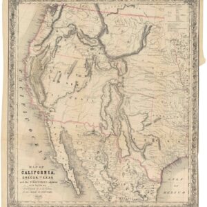
One of the most comprehensive and excellent atlases of coastal North America produced in the 18th century, the Neptune Americo-Septentrional was an influential compilation of maritime charts. It was first compiled under Antoine Sartine, Minister of the French Navy during the American Revolutionary War. Explicitly designed for strategic navigation, the atlas provides the most comprehensive collection of meticulous coastal surveys of North America at the time, and was integral to French naval operations during the Revolutionary War.
In scope, the collection spans from Greenland to the Gulf of Mexico, encompassing key areas of French interest such as Florida and Louisiana, but also providing detailed plans of most ports on the East Coast. The atlas contains 36 charts and plans, including locations like Chesapeake Bay, Boston Harbor, Charleston Harbor, Narragansett Bay, Port Royal, New York Harbor, and the Delaware Bay and River to Philadelphia.
Revolutionary cartography
The compilation of this atlas was initiated by Antoine Sartine, minister of the French Navy. Sartine was known for his modernization of the Navy, which included the compilation of significant and reliable accumulations of charts. The Neptune Americo-Septentrional combines and integrates French and foreign cartographic sources. However, it is further enriched by including manuscript plans and the alignment of its charts with the latest astronomical observations. In unison, this collection of charts offered unprecedented precision in the cartographic depiction of America’s Atlantic coast and its associated waterways. This proved valuable in the ongoing conflict with the British and played a crucial role in the operations of the French navy during the Revolutionary War. As such, the Neptune was essential to the French engagement in the American Revolution.
Despite the ongoing conflict between England and France, the Neptune was such an essential cartographic advancement that it soon spread beyond the confines of the French Navy. William Faden, a leading English cartographer, acquired three copies and distributed them to notable figures in England. The Dépôt de la Marine, responsible for the Neptune’s publication, also sent a copy to Benjamin Franklin, in which they highlighted the intertwining of scientific, military, and diplomatic information. To this day, the Neptune is considered among the finest accumulations of Atlantic maps and charts, cementing its legacy as a milestone in the cartographic history of America.
Census
The OCLC lists thirteen institutional libraries that retain a copy of this rare atlas (no. 1120059). The list includes several American university libraries and the Library of Congress.
List of Maps
- Carte Réduite des Côtes Orientales de L’Amérique Septentrionale contenant Celles des Provinces de New-York et de la Nouvelle Angleterre, celles de l’Arcadie ou Nouvelle Ecosse de l’ile St. Jean avec l’intérieur du Pays (1780)
- Carte Réduite des Côtes Orientales de L’Amérique Septentrionale contenant Partie du Nouveau Jersey, la Pen-sylvanie, le Mary-land, la Virginie, la Caroline Septentrionale, la Caroline Méridionale et la Géorgie (1778)
- Plan de L’Île de St. Jean (1778)
- Carte de la Baie des Chaleurs (1780)
- Plans Particuliers Dépendans de L’Île Royale [5 plans on 1 sheet]
- Carte Réduite de L’Ile Royale (1780)
- Plan de la Ville du Port de Louisbourg levé en 1756 (1779)
- Plan de la Baie de Gabarus (1779)
- Plan de la Baie de Nerichac (1779)
- Plan de Port Toulouse (1779)
- Plan du Port Dauphin (1778)
- Plan du Port de Chibouctou (1779)
- Plan du Port de la Rivière St. Jean (1779)
- Plan du Port de la Heve
- Plan du Port Rochelois
- Plan de l’Isthme de L’Acadie (1779)
- Plan de la Baie et du Havre de Casco (1779)
- Plan du Bassin et de la Rivière du Port Royal ou Annapolis (1779)
- Carte Particulière du Havre de Boston (1780)
- Plan de la Baie de Narraganset (1780)
- Carte de la Baye et Rivière de Delaware (1778)
- Carte de l’Entrée de la Rivière d’Hudson (1778)
- Carte de la Baie de Chesapeake (1778) [inset map] Plan de la Baie Herring en Maryland
- Plan de la Rivière du Cap Fear (1778)
- Plan de la Barre et du Havre de Charles-town (compiled in 1778 based on an English plan from 1776)
- Plan de Port Royal et de la Rivière et du Détroit d’Awfoskée (1778)
- Plan de l’Ile d’Amelia à la Cotê de la Floride Orientale (1779)
- Plan de la Barre et de l’entrée de la Riviere de Nassau
- Plan de la Barre et du Port d’Amelia à la Cotê de la Floride Orientale (1779)
- Carte d’une partie des côtes de la Floride et de la Louisiane contenant le cours du Mississipi (1778)
- Carte réduite des côtes et de la presqu’île de la Floride (1780)
Cartographer(s):
The Dépôt de la Marine, officially the Dépôt des cartes et plans de la Marine, served as France’s central institution for chart-making and hydrography. Established in 1661, the initial steps towards centralizing hydrography included the inauguration of the Royal School of Hydrography and the first survey of France’s coasts (1670-1689). By 1680, a number of essential chart collections constituted the base collection of the Dépôt.
Functioning as the central repository of charts for the French Navy, the Dépôt soon evolved. In 1720, it merged with government archives covering the colonies, becoming an even more comprehensive repository of nautical knowledge. From 1737, the Dépôt began producing its own original charts, and by 1750, it actively participated in scientific expeditions to map distant shores and enhance longitude calculations.
In 1773, the Dépôt gained a monopoly over the production and distribution of maritime materials. Dépôt-approved charts, created by esteemed mapmakers like Philippe Bauche, Jacques-Nicolas Bellin, Rigobert Bonne, Jean Nicolas Buache, and Charles-François Beautemps-Beaupré, were of the highest quality and distributed to officials in port cities across France. The charts were also sold by authorized dealers. In 1886, the Dépôt was transformed into the Naval Hydrographic Service., which in turn became the Naval and Oceanographic Service (SHOM) in 1971.
Despite these changes, the fundamental purpose of providing high-quality cartographic and scientific information to France’s navy and merchant marines remained. The historical archives of the Dépôt were transferred to the Bibliothéque national de France in the 1990s.
Condition Description
Folio. Full contemporary French calf with a trellis-and-dot design, a large gilt device of the French Royal Coat of Arms at the center of both covers, the covers ruled with three-line gilt roll-tool; spine in eight compartments separated by raised bands, red morocco title piece in the second gilt-lettered "NEPT | AMER | SEPTENT", the rest with gilt-tooled floral designs.
Contemporary blue paper endpapers. Engraved title, 26 engraved charts on 13 full sheets and 5 half sheets, by Sartine and others.
References
Howes N-52; Phillips, Atlases 1211; Howes N52; Sabin 52337.