-
-
Add to cart
 Quick View
 - Africa, Egypt
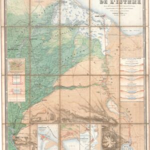
Compagnie universelle du canal maritime de Suez. Carte de l’Isthme.
- $5,000
- 1866 First Edition Map of the Suez Canal, Printed Before the Canal's Completion and Later Pirated by the Imperial German Army.
-
-
-
-
Add to cart
 Quick View
 - British Isles, Europe
The River of Thames from London to the Buoy of the Noure.
- $1,800
- 1693 ca. Collins Nautical Chart of the Thames Estuary, with Inset Town Plan and Fleet Cartouche.
-
-
-
-
Add to cart
![In Omaggio alle Glorie della Scienza Elettro-Galvanica [In homage to the glories of electro-galvanic science].](https://neatlinemaps.com/wp-content/uploads/2026/06/NL-02695_thumbnail-300x300.jpg) Quick View
Quick View - Curiosities - Miscellanea
In Omaggio alle Glorie della Scienza Elettro-Galvanica [In homage to the glories of electro-galvanic science].
- $1,600
- Unrecorded c. 1900 Italian Commemorative Lithographic Broadside Honoring Galvani, Volta, Ferraris, and Marconi.
-
-
-
-
Add to cart
 Quick View
 - Europe, Italy
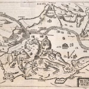
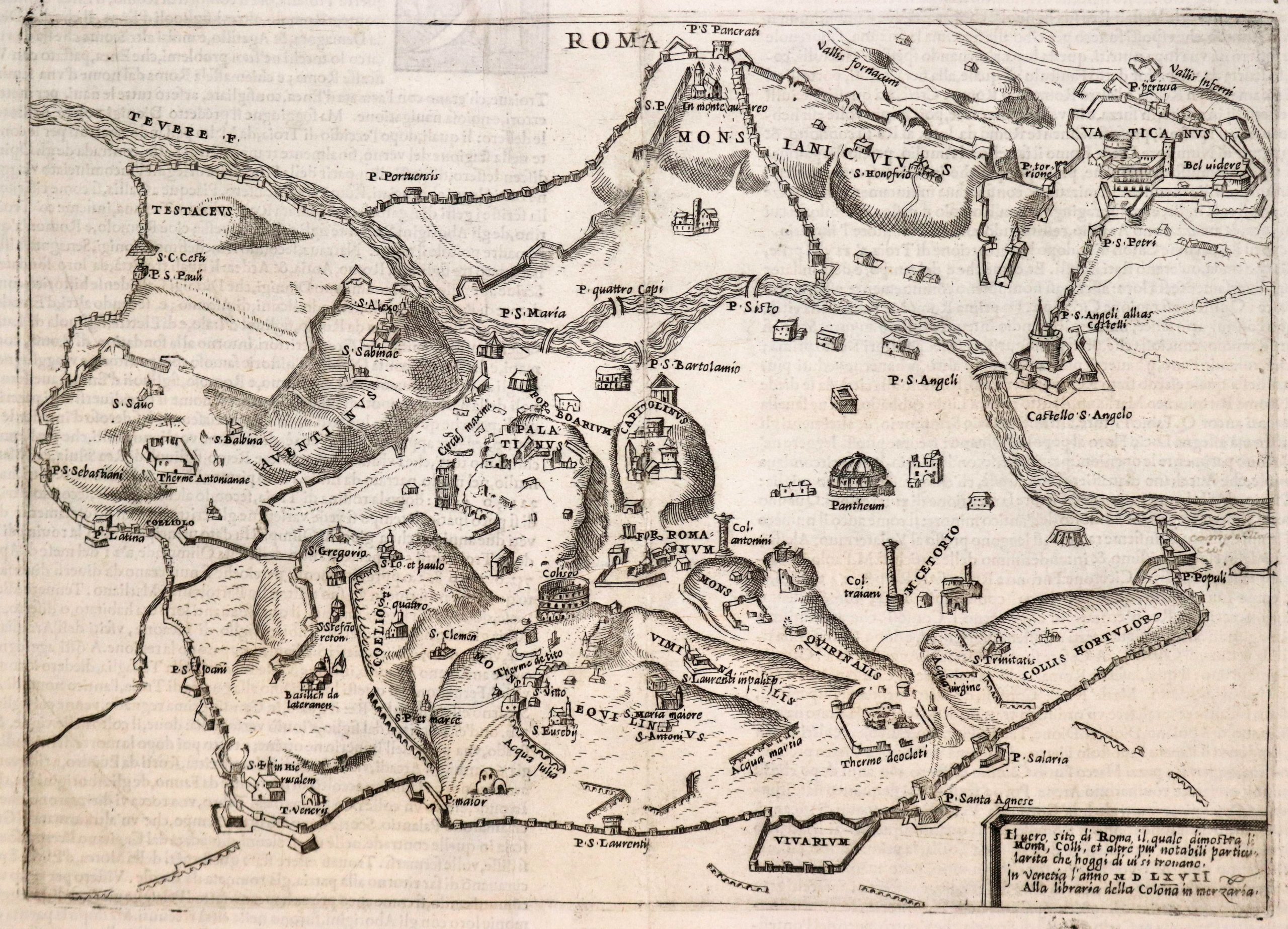
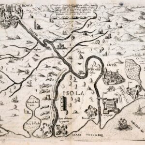
Il vero sito di Roma il quale dimostra li Monti, Colli, et altre più notabili particolarita che hoggi di ui si trouano.
- $1,300
- 1567 Forlani Plan of Rome, Second Issue from Ballino's De' Disegni delle Più Illustri Città, Published by Zaltieri in Venice.
-
-
-
-
-
Add to cart
 Quick View
 - Europe, Italy
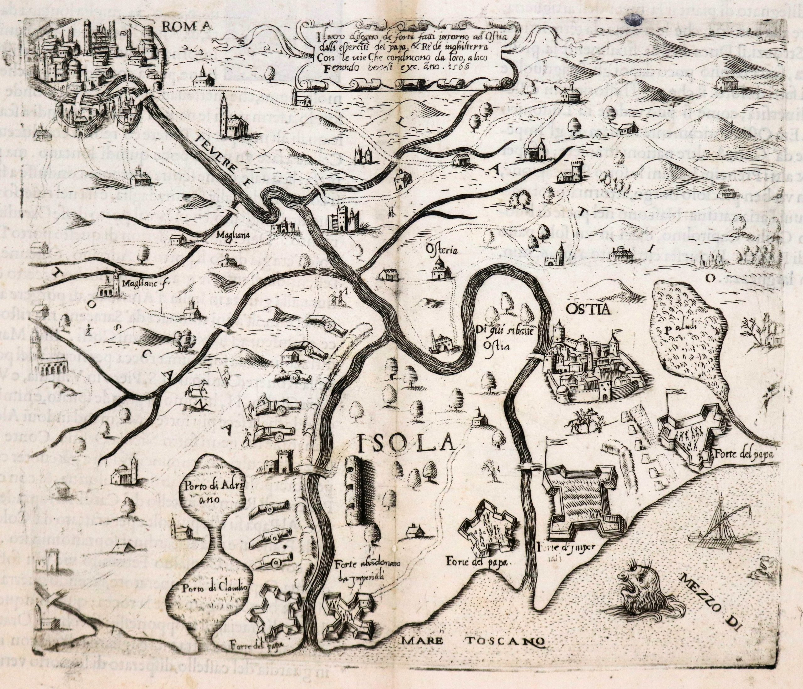
Il vero disegno de forti fatti intorno ad Ostia…
- $1,500
- Forlani/Berteli, Venice, 1566 — Military Map of the Forts Around Ostia and the Tiber from Rome to the Gulf of Tuscany.
-
-
-
-
-
Add to cart

 Quick View
 - Bird's-eye-views, Eastern Mediterranean - Holy Land
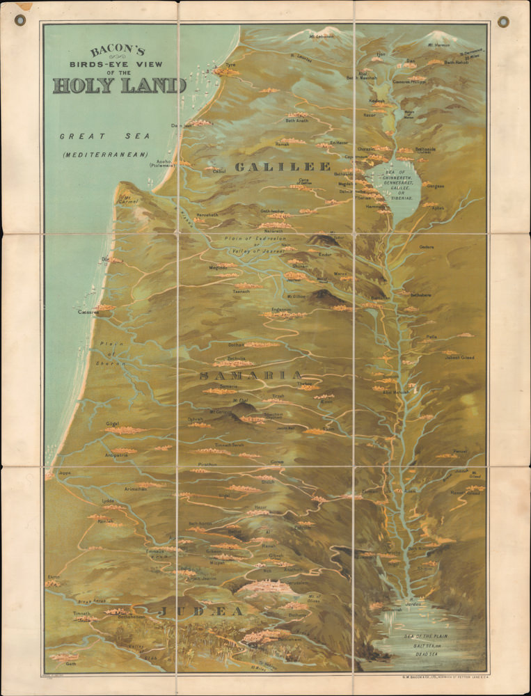
Bacon’s Bird’s-Eye View of the Holy Land.
- $1,800
- George Washington Bacon’s iconic bird’s-eye-view of the Holy Land.
-
-
-
-
-
Add to cart
 Quick View
 - Eastern Mediterranean - Holy Land, Middle East - Holy Land Maps
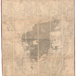
Ordnance Survey of Jerusalem By Captain Charles W. Wilson R.E. Under The Direction of Colonel Sir Henry James, R.E. F.R.S. & C. Director of the Ordnance Survey. 1864-5.
- $3,500
- 1865 British Survey of Jerusalem: the First Scientific Mapping of the City and its Environs.
-
-
-
-
Add to cart
 Quick View
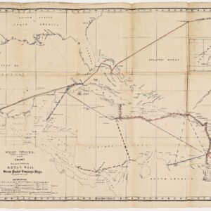
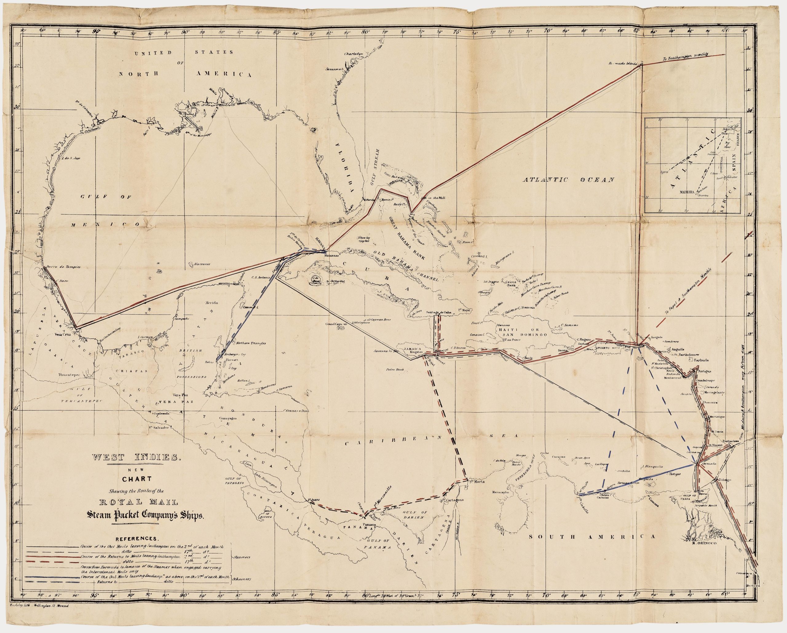
 - Americas, Cuba, West Indies, Caribbean
West Indies. New Chart shewing the Routes of the Royal Mail Steam Packet Company’s Ships.
- $2,400
- The communications lifeline of the British Caribbean: an unrecorded map of the Royal Mail Steam Packet Company’s Ships to the West Indies.
-
-
-
-
-
Add to cart
 Quick View
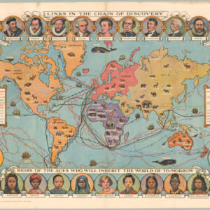
 - World, Curiosities - Miscellanea, Pictorial maps
Cassell’s Children’s Book of Knowledge Wonder Map of the World.
- $450
- Thematic mapping for children: a fabulous circa 1930 world map depicting the history of exploration.
-
-
-
-
-
Add to cart
 Quick View
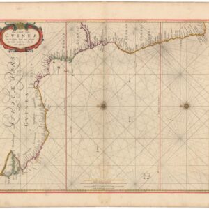
 - Africa
Pas-Caart van Guinea en de Custen daer aen gelegen Van Cabo verde tot Cabo de Bona Esperanca.
- $750
- 1670s Goos Sea Chart of the West African Coast from Cape Verde to the Cape of Good Hope.
-
-
-
-
Add to cart
 Quick View
 - Europe, Iceland & Scandinavia
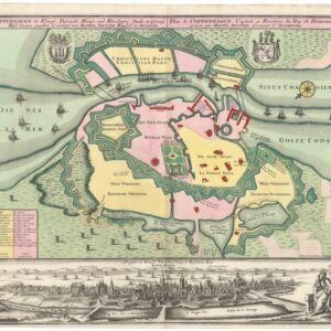
Coppenhagen die Königl. Dänische Haupt und Residentz Stadt in Grund Riss.
- $1,600
- 1740 Seutter Ground Plan of Copenhagen with Panoramic View.
-
-
-
-
Add to cart
![[The Isle of Wight and the Solent Approaches]](https://neatlinemaps.com/wp-content/uploads/2026/05/NL-02635_thumbnail-300x300.jpg) Quick View
Quick View - British Isles, Europe
[The Isle of Wight and the Solent Approaches]
- $800
- 1693 Collins Nautical Chart of the Isle of Wight, the Solent, and the Approaches to Portsmouth and Spithead.
-
-
Shop
All maps in stock, sorted by latest.