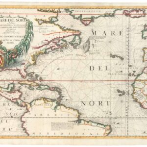
An unusual depiction of America’s changing borders in the Jacksonian Era.
General Charte von America nach dem besten hilfsmitteln.
Out of stock
Description
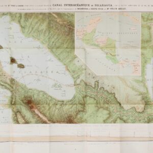
This intriguing and very rare 1827 map of the Americas was made by Friedrich Wilhelm Spehr. Aside from its beautiful engraving and hand coloring, it is notable for its unusual depiction of the borders of the United States.
At the time this map was made, the only permanent non-Native settlers in the future American states of Washington and Oregon were fur traders of the Hudson Bay Company (HBC). The border between the United States and British North America was continuously disputed in the decades following the War of 1812. An agreement reached in 1818 allowed for “joint occupancy,” though the HBC (which had been forcibly merged with its bitter rival the North West Company in 1821) remained the major non-indigenous actor in the region. Meanwhile, American agents of John Jacob Astor’s Pacific Fur Company tried to stake out a claim over the same territory.
Debates centered around the basis for the border (at either the 49th or 51st degree north parallel, or later some American demands up to the 54th parallel) and British requirements to control the Strait of Georgia and the Strait of Juan de Fuca. Spehr looks to be proposing something else entirely, with a portion of America jutting into British territory along the Rocky Mountains around today’s Banff National Park, resolving at a border close to where it lies today. In any event, negotiations dragged on for decades and nearly came to war in the 1840s, but the border was finally settled in 1872.
Similarly, the U.S. border with Mexico depicted here basically follows the Adams–Onís Treaty of 1819, with some unique modifications. Spehr looks to be operating on the original American understanding of the Louisiana Purchase that it extended to the Rio Grande (Rio del Norte here), and therefore that the 1819 treaty would have ceded the entire Rio Grande, all the way into what is now Colorado, to Spain, when in reality a more complex border that was more generous to the U.S. was agreed upon.
These oddities reflect the still-developing geographic knowledge of territories west of the Mississippi River, the competing claims of various empires (Spain and Russia also made claims to the Pacific Northwest), and the delays in disseminating information about treaties and border disputes across the Atlantic.
Census
This map was drawn by Friedrich Wilhelm Spehr and printed in Braunschweig at the Kunst und geographisches Bureau. It is dated 1827 and was intended to appear in Spehr’s Geographischer Universal-Atlas, a work that was begun in 1822 but never completed. In the interim, Spehr had published a Hand-Atlas von America (1827), which may explain his close attention to and unusual interpretations of disputed and changing borders. There are no other known examples of this map either in institutional collections or on the market.
Cartographer(s):
Friedrich Wilhelm Spehr’s Geographischer Universal-Atlas was started between 1822 and 1825 but never completed, with only 36 of the 90 planned maps actually printed.
Condition Description
Very good. Two small holes at top margin.
References