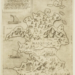
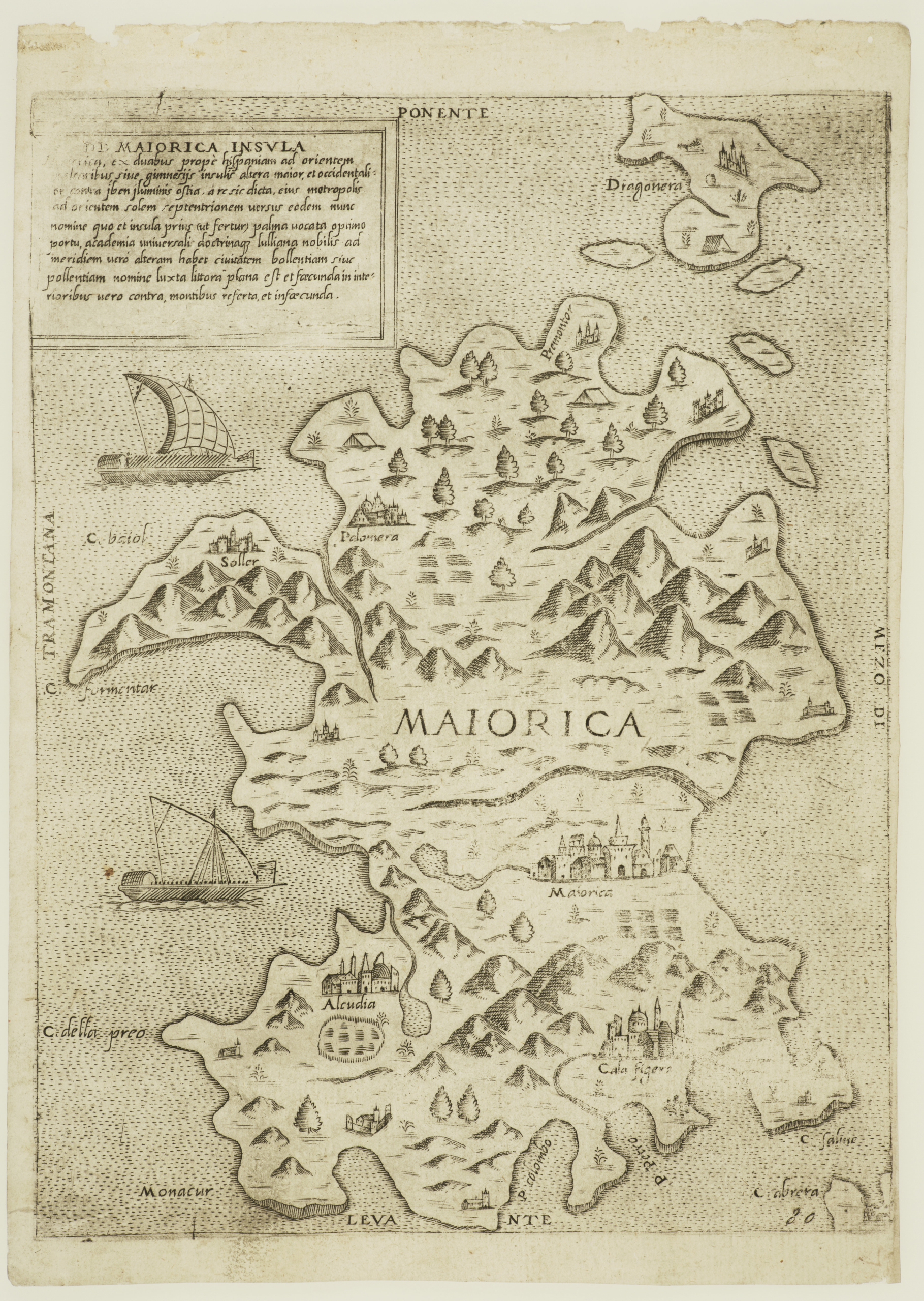
Extremely rare Lafreri-school map of the island of Mallorca.
De Maiorica Insula
Out of stock
Description
This is exceptionally rare map of Mallorca orients the island with west at the top, and situates it at the center of the four classical winds: TRAMONTANA, MEZZODI, PONENTE, LEVANTE. It is undated, but signed by Ferrando Bertelli, and belongs to his cartographic series of Mediterranean islands, first published in 1560. Examples of this map were occasionally included in the 1568 and 1574 editions of Civitatum aliquot insignorum, by Donato Bertelli.
From a cartographic point of view, the map is characterized by a fascinating error. The geography of island is reversed, the position of Palma, Capo Formentor, and the island of Dragonera are mirrored to reality. This error is most likely because the map was engraved in the same direction as the drawing from which it was taken.
At the time this map was published, the Balearic were the target of frequent attacks by Barbary pirates from North Africa. In response, coastal watchtowers were constructed and churches were fortified, as seen in many of the cities depicted on the map.
This is the first state of the map, with Ferrando Bertelli’s signature.
Also within the excellent strap work cartouche is a description of the island, in Latin:
DE MAIORICA INSULA. MAIORICA ex duabus prope hispaniam ad orie[n]tem belearibus, sive gimnesis insulis altera maior et occidentalior contra iben iluminis ostia, à re sic dicta eius motropolis ad orientem solem septentrionem versus eodem nunc nomine quo et insula prius ut fetur palma vocata optimo portu, academia universali doctrina q[uae] lulliana nobilis ad meridiem vero alteram habet civitatem bollentiam sive pollentiam nomine Iuxta littora plana est et saecunda in interioribus vero contra, montibus referta et infaecunda. Ferando bertelli. Exc.
Cartographer(s):
The Bertelli family represents the largest group of publishers, engravers, cartographers, and merchants of 16th century prints. The most productive was Ferrando Bertelli, active between 1560 and 1570, but maps of the last quarter of the century are known with the signatures of Andrea, Donato, Lucca, Nicolò, and Pietro. The latter was mainly active in Padua, where he led a printing and engraving workshop.
Condition Description
Optimal example.
References
Almagià (1927): n. 22; Almagià (1948): p. 104, n. 44; Borroni Salvadori (1980): n. 25; Christie’s (2004): n. 506; Christie’s Ln (2006): n. 127; Christie’s Pa (2006): n. 219; Christie’s (2011): n. 52; Dzikowski (1940): n. 15; Kraus (1972): n. 87; Meurer (2002): n. 80; Mostra Bergamo (2016): n. 34; Parke-Bernet (1969): n. 9; Ruge (1904-16): I, n. 67.4 e IV, n. 88.19; Shirley (2004): I, n. 37; Tavernari (2014): n. 10; Wieder (1915): p. 29, 61; 700 anys de cartografia de les Illes Balears (1986): n. 40; Cartografia De Les Illes Balears (2000): pp. 136-137, n. 60; Nordenskiöld (1981): n. 12(11); Tooley (1939): n. 355.