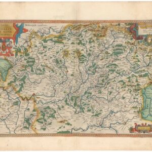
A wonderfully detailed mid-19th century map of France.
France.
Out of stock
Description
An impressive c. 1850 map of France that appeared in William and Alexander Keith Johnston’s The national atlas of historical, commercial, and political geography, a work noted for its craftsmanship and importance for popularizing physical geography.
‘Military circles,’ a relic of the Napoleonic era roughly corresponding with today’s régions, are shaded and outlined in hand color, while départements are labeled in large text. Cities and towns, waterways, roads, railways (existing and proposed), and other features are noted in fantastic detail.
A French-English glossary of geographical terms appears at bottom-left. An inset of France divided into provinces as it appeared in 1789 appears at left, while and inset of Corsica appears at bottom-right.
Cartographer(s):
William and Alexander Keith Johnston were Scottish brothers based in Edinburgh who operated a prominent map engraving and printing business in the mid-19th century. A.K. Johnston was the driving force behind the business and remained in the world of cartography throughout his life, while William later entered politics, serving as the Lord Provost of Edinburgh and being knighted for his service. Johnston’s maps and atlases earned high praise for their accuracy and comprehensiveness (A.K. Johnston was strongly influenced by Alexander von Humboldt).
Condition Description
Very good. Toning along edges. Light foxing. Some wear on centerfold.
References


![[LA ROCHELLE] Il vero sito della Rocella hora occupata da heretici et Ribelli di sua Maestà Christianissima della Quale sono Assediati.](https://neatlinemaps.com/wp-content/uploads/2022/11/NL-01639_thumbnail-scaled-300x300.jpg)
![[LA ROCHELLE] Il vero sito della Rocella hora occupata da heretici et Ribelli di sua Maestà Christianissima della Quale sono Assediati.](https://neatlinemaps.com/wp-content/uploads/2022/11/NL-01639_thumbnail-scaled.jpg)