A fine 17th-century map of Switzerland and parts of Italy, including Lake Como.
L’Helvetia o’ Paese de Suizzeri…
Out of stock
Description
A lovely map with a strong impression showing the 13 Swiss Cantons with excellent topographical detail. It is a richly detailed and informative work, blending geographic and political insights. Parts of northern Italy are depicted, including Lago Maggiore and Lago di Como.
The Swiss Alps and Jura Mountains are prominently featured. Major lakes like Lake Geneva (Lac Léman), Lake Constance (Bodensee), Lake Lucerne (Vierwaldstättersee), and Lake Zurich are depicted. Rivers such as the Rhine, Rhône, and Aare are shown with flow directions and tributaries marked.
Major historical routes and mountain passes, such as the Gotthard Pass and the Simplon Pass, are included to highlight their importance for trade and travel.
In 1686, Switzerland was a collection of semi-autonomous cantons that formed the Old Swiss Confederacy. This period is characterized by relative stability and neutrality within Europe, particularly following the Thirty Years’ War (1618-1648). The war devastated the continent but left Switzerland relatively unscathed compared to its neighbors.
Cartographer(s):
Giacomo Cantelli da Vignola (1643–1695) was a prominent Italian cartographer known for his detailed and decorative maps, which significantly contributed to the field of cartography in the 17th century. Born in Vignola, near Modena, Italy, little is known about his early life and education. Cantelli began his cartographic career in the late 17th century, a period marked by increasing sophistication and artistry in mapmaking. He was renowned for his maps’ accuracy and intricate details, often embellished with elaborate cartouches and mythical figures, making them both practical and aesthetically pleasing.
Cantelli produced numerous maps covering various regions of Europe, Asia, and Africa, many of which were included in atlases published by prominent publishers such as Giovanni Giacomo De Rossi in Rome. His maps of Italy, the Balkans, and the Mediterranean region were particularly well-regarded for their precision and detail. Cantelli’s collaboration with De Rossi helped disseminate his work widely, establishing his reputation as a leading cartographer of his time.
Cantelli’s influence on cartography extended beyond his lifetime, setting a standard for mapmaking in the late 17th and early 18th centuries. His combination of artistic elements with geographical accuracy was admired and emulated by other cartographers. Today, Cantelli’s maps are valuable historical documents preserved in libraries, museums, and private collections worldwide, providing insights into the geographical knowledge and artistic sensibilities of the 17th century. Giacomo Cantelli da Vignola remains a significant figure in the history of cartography, remembered for his meticulous and beautifully crafted maps that advanced geographical knowledge during his era.
Giacomo Giovanni de RossiGiovanni Giacomo de Rossi (1627–1691) was an Italian engraver and printer, active in Rome in the second half of the 17th century. He was born in Vignola and was the first official cartographer of the Court of Modena, in 1685, when the Duke Francis II appointed him geographer.
His father, Giuseppe de Rossi, was the founder of the most important and active printing press of the 17th century in Rome.
Condition Description
Stron impression. Sporadic staining, discoloration along centerfold and edge.
References
Related products
-
-
Add to cart
- Europe, Italy, Bird's-eye-views
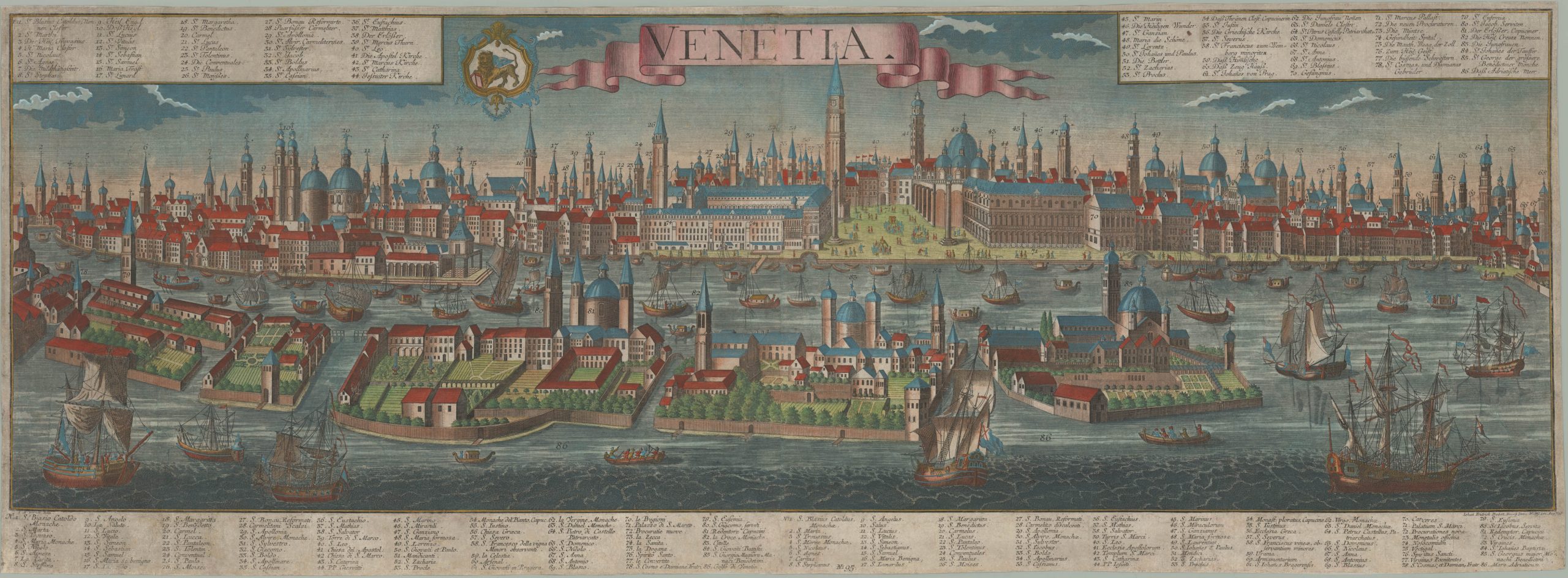
Venetia.
- $4,800
-
-
-