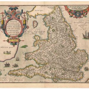
Sebastian Münster’s 1567 Map of France.
Das gantz Frankreich so vor Zeiten Gallia Narbonensis, Bugunensis, Belgica und Celtica ist genannt worden.
$450
1 in stock
Description
Shaping French National Identity During the Wars of Religion.
Sebastian Münster’s map of France, published in the German edition of Cosmographia Universalis, is a remarkable example of 16th-century cartographic artistry and scholarship. This woodcut map, measuring approximately 25 x 34.5 cm (10 x 13.6 inches), is recognized not only for its detailed depiction of French geography and ornamental embellishments but also for being one of the first modern maps of France.
The classification of this map as “modern” suggests that its design deviated from established cartographic traditions, marking a shift away from Ptolemaic geography, which had dominated mapmaking throughout the 15th and early 16th centuries. Münster employs his characteristic illustrative style, incorporating vignettes of rivers, towns, and forests, adding visual appeal while maintaining geographical accuracy.
A striking feature of this map is the large fleur-de-lis coat of arms, symbolizing both France and its monarchy. This emblem serves not only as a decorative element but also as a patriotic marker, reinforcing France’s national identity at a time of religious and political upheaval.
On the left side of the map, Münster includes a legend listing ancient Roman town names alongside their contemporary Latin and French equivalents. This serves two important purposes:
1. It underscores the continuity of France’s historical identity, linking it to its Roman past.
2. It reflects the Renaissance fascination with antiquity and its influence on 16th-century European thought.
The reverse side of the map features a decorative border surrounding the title, adorned with imagery of heralds, geographers, and their tools. This artistic addition reinforces the scholarly and aesthetic significance of Münster’s work.
A Revolutionary Approach to Cartography
Münster’s map was a cornerstone in the development of independent, observation-based mapping in Europe. His influential methods made the latest geographic knowledge accessible to a wide audience, allowing for the dissemination of new information and contributing to the political and intellectual trends of the era.
By integrating scientific cartographic techniques with aesthetic elements, Münster’s map of France embodies the early modern shift in geographic representation—one that reflected both territorial realities and emerging national identities. It stands not only as a testament to Münster’s genius but also as an artifact from an era that played a crucial role in shaping the modern world.
Publication information
The present map originates from a German edition of Cosmographia Universalis, published in Basel in 1567. This monumental geographical and cosmological work succeeded Münster’s earlier Geographia.
The German edition of Cosmographia played a particularly significant role in expanding the reach of Münster’s work. Unlike the Geographia, which was published solely in Latin, the Cosmographia appeared in German, Latin, French, and Italian, making it accessible to a broader European audience.
By 1567, the printing block for this map was beginning to show signs of wear, a testament to its repeated use and enduring popularity.
Cartographer(s):
Sebastian Münster (1488-1552) was a cosmographer and professor of Hebrew who taught at Tübingen, Heidelberg, and Basel. He settled in Basel in 1529 and died there, of the plague, in 1552. Münster was a networking specialist and stood at the center of a large network of scholars from whom he obtained geographic descriptions, maps, and directions.
As a young man, Münster joined the Franciscan order, in which he became a priest. He studied geography at Tübingen, graduating in 1518. Shortly thereafter, he moved to Basel for the first time, where he published a Hebrew grammar, one of the first books in Hebrew published in Germany. In 1521, Münster moved to Heidelberg, where he continued to publish Hebrew texts and the first German books in Aramaic. After converting to Protestantism in 1529, he took over the chair of Hebrew at Basel, where he published his main Hebrew work, a two-volume Old Testament with a Latin translation.
Münster published his first known map, a map of Germany, in 1525. Three years later, he released a treatise on sundials. But it would not be until 1540 that he published his first cartographic tour de force: the Geographia universalis vetus et nova, an updated edition of Ptolemy’s Geography. In addition to the Ptolemaic maps, Münster added 21 modern maps. Among Münster’s innovations was the inclusion of map for each continent, a concept that would influence Abraham Ortelius and other early atlas makers in the decades to come. The Geographia was reprinted in 1542, 1545, and 1552.
Münster’s masterpiece was nevertheless his Cosmographia universalis. First published in 1544, the book was reissued in at least 35 editions by 1628. It was the first German-language description of the world and contained 471 woodcuts and 26 maps over six volumes. The Cosmographia was widely used in the sixteenth and seventeenth centuries and many of its maps were adopted and modified over time, making Münster an influential cornerstone of geographical thought for generations.
Condition Description
Hand color. Visible repairs, as seen on the image. Overall nice.
References