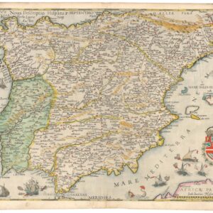
Fine 1635 map of Portugal by Merian based on Portuguese sources
Portugallia et Algarbia quae olim Lusitania
Out of stock
Description
Finely-engraved map of Portugal, based upon an earlier map by Willem Blaeu. The cartography itself is based on the work of Portuguese chart maker Fernando Alvarez Secco.
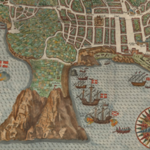
Includes a decorative cartouche and scale of miles, 2 coats of arms, 2 sailing ships and an image of Neptune, trident in hand, riding a whale.
Cartographer(s):
Matthäus Merian (September 1593 – 19 June 1650) was a Swiss-born engraver who worked in Frankfurt for most of his career, where he also ran a publishing house. He was a member of the patrician Basel Merian family.
Early in his life, he had created detailed town plans in his own unique style, for example plans of both Basel and Paris (1615). With Martin Zeiler (1589 – 1661), a German geographer, and later (circa 1640) with his own son, Matthäus Merian produced a collection of topographic maps. The 21-volume set was collectively known as the Topographia Germaniae and included numerous town-plans and views, as well as maps of most countries and a world map. The work was so popular that it was re-issued in many editions. He also took over and completed the later parts and editions of the Grand Voyages and Petits Voyages, originally started by Theodor de Bry in 1590. Merian’s work inspired the Swedish royal cartographer, Erik Dahlberg, to produce his Suecia Antiqua et Hodierna, which became a cornerstone in European mapping.
After his death, his sons Matthäus Jr. and Caspar took over the publishing house. They continued publishing the Topographia Germaniae and the Theatrum Europaeum under the name ‘Merian Erben’ (i.e. Heirs of Merian). Today, the German travel magazine Merian is named after him.
Condition Description
Paper is age toned with some foxing; reinforced centerfold.
References