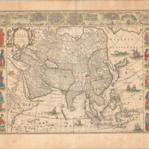
An extraordinarily detailed wall map of British interests and possessions in the Indian Subcontinent at the dawn of the 19th century, executed by one of the Empire’s foremost cartographers.
To Mark Wood Esq. M.P., Colonel of the Army in India, Late Chief Engineer and Surveyer General, of Bengal, This Map of India Compiled from various Interesting and Valuable Materials Is Inscribed in Grateful Testimony of His Liberal Communications By his obedient and most humble Servant A. Arrowsmith.
Out of stock
Description
This magnificent wall map, compiled by Aaron Arrowsmith, one of the most important cartographers of his era, details British possessions and interests in India at the turn of the century. At this time in the hands of the British East India Company (BEIC), India had become a vital supplier of the Empire and a stepping-stone for further colonization of Asia.
The map was executed before British control of the Subcontinent had been fully established. Consequently, the different regions or presidencies under the control of the BEIC are depicted with varying levels of detail, depending on their prominence in commercial systems. Coastal provinces such as Bengal and Andhra Pradesh in the north and the Coromandel and Malabar coasts in the south are shown in great detail. The same goes for Sri Lanka (then known as Ceylon), revealing where British assets were concentrated. But the inland regions stretching from the Bay of Bengal towards Uttar Pradesh, Delhi, and the Indus Valley have also been lent considerable importance and hint at Britain’s growing colonial ambitions.
In addition to recording as many place names as possible, Arrowsmith closely studied records from the British Army’s route surveys to compile a precise rendition of India’s transport infrastructure. The map also includes a plethora of physio- or topographic features, notations on the presence of natural resources, and seasonal navigation tips on the seaborne approach to Calcutta.
In addition to fortifying and expanding British dominion, the British Army combined military expeditions with cartography, mapping out routes and road networks as they traversed them. The close connection between cartography and military expeditions is seen in the dedication of this map to Sir Mark Wood, a British army officer and engineer who had a distinguished career in India, culminating in his appointment as surveyor-general in 1787 and chief engineer of Bengal in 1790. The work of this office constituted a foundation without which Arrowsmith’s work would not have been possible.
*The map is scarce in institutional records, with OCLC Worldcat listing only three examples: British Library, Harvard, and BNF.
Background
At the dawn of the 19th century, India had not yet been fully converted into a British colony as we know it. British soldiers had served in the region for more than a century, but for the most part, their job was to facilitate the activities of the British East India Company, which operated out of the Subcontinent. During the 19th century, British policy became increasingly focused on securing and expanding its control of India’s territories and the vast resources they represent. India was viewed as the gateway to the commercial and military dominion of Southeast Asia.
The BEIC and the British Navy had been efficient partners since the Seven-Years’ War (1756-63) and continued to rely on the mutual benefit of this alliance to acquire new territories for the Crown. Joint missions included the capture of Dutch Java in 1811, the annexation of Singapore in 1819 and Malacca in 1824, and the occupation of Burma in 1826. The British East India Company’s base of operations was India, from where they controlled both the production and export of key commodities such as textiles, tea, and spices.
Cartographer(s):
Aaron Arrowsmith (1750-1823) was perhaps his generation’s most influential English mapmaker. He served as hydrographer to the British Royal Family from 1810 until his death. Born in County Durham in northern England, Arrowsmith moved to London around 1770, where he won an apprenticeship under William Faden, the royal cartographer of King George III. Soon after, Arrowsmith began studying engraving under John Cary, who had set up a successful business focused on mapmaking despite being only a few years his senior.
One of the accomplishments that secured Arrowsmith’s renown as a cartographer was his chart of the world based on the Mercator projection, which he published in 1790. Some years later, a second world map based on globular projection was published. In the coming years, Arrowsmith dedicated himself to producing detailed maps of the British Empire and beyond, famously creating his first North American chart in 1796, followed by a range of seminal maps depicting The South Pacific (1798), The West Indies and Spanish Dominions in America (1803), The Indian Subcontinent (1804), Egypt (1807), Scotland (1807), Mexico (1803 & 1810), South Africa (1815) and The North Pole (1818). His 1790 map of America was re-issued several times, the most important of which was in 1802. The detailed study of this particular map was a crucial part of Lewis and Clark’s preparations for the great Corps of Discovery expedition (1803-1806).
In 1804, Arrowsmith joined forces with Samuel Lewis of Philadelphia to produce the New and Elegant General Atlas Comprising all Discoveries to the Present Time, which for many years set an American standard for compiling popular atlases.
In 1810, Arrowsmith was appointed royal hydrographer to the Prince of Wales, who appointed him as hydrographer to King George IV upon ascending the throne a decade later. His success prompted several family members to follow in his footsteps (most notably his son Aaron and his nephew John), establishing a line of English cartographers carrying the Arrowsmith name.
Mount Arrowsmith on Vancouver Island is named after him.
George AllenGeorge Allen was a London-based publisher active in the late 18th and early 19th centuries.
Condition Description
Six sheets, in three sections joined. Light browning throughout. Sheets mounted on fine Belgium linen. Original color. Excellent condition.
References
OCLC lists only three institutional examples: British Library, Harvard, and BNF.
Allen, David Y. (2017). Mapping in Humboldt’s Shadow: Aaron Arrowsmith and the Cartography of Mexico, 1803-1825. Terrae Incognitae 49,1: 50-67
Verner, Coolie (1971). The Arrowsmith Firm and the Cartography of Canada. Cartographica: The International Journal for Geographic Information and Geovisualization 8,1: 1-7
Wood, Greg (2012). Successive States: Aaron Arrowsmith’s Chart of the Pacific Ocean, 1798-1832. The Globe 70: 1-17