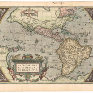
Dezauche’s exquisite chart of the Gulf Coast, Florida, and Caribbean Archipelago depicts a French Colonial Empire that is slowly falling apart.
Carte Du Golphe Du Mexique Et Des Isles Antilles Reduite de la grande carte Angloise de Popple, Par PH. Buache…1780.
Out of stock
Description
This striking and intricate map of the Gulf of Mexico and Caribbean Archipelago was compiled by J.A. Dezauche, the successor to Philippe Buache and Guillaume De L’Isle. It was printed in Paris in 1780 and measures an impressive 36 x 20 inches (91 x 51 cm). The map was undoubtedly intended for careful visual inspection, as is evidenced by the incredible level of accuracy and detail. Geographically, the scope of the map extends well beyond the Gulf of Mexico and Caribbean to also include the Florida coastline, the entire isthmus of Central America, and most of South America’s north coast. It is, in effect, the perfect overview chart for anyone seeking to understand navigation and geography in the most densely populated part of the New World.
Both on the larger islands and on the mainland, mountain ranges, rivers, lakes, and settlements are all highlighted. In addition to the toponymic and topographic details, we find a wealth of thematic information on this chart. This includes political structures and boundaries, extensive data on local wind regimes and currents, and conversion rates between various measuring systems. Within each of the different maritime spaces (i.e. Atlantic, Pacific, Gulf, and Caribbean), rhumb-lines dominate, denoting not only the map’s nautical applicability, but also the immense commercial interests that France and other countries had in this region. This nautical element is further confirmed by the presence of sounding boundaries along much of the coast and the larger islands. These assisted navigators in understanding where reliable depth measurements could no longer be obtained.
Also found are dot-and-dash lines delineating the direction and season of the so-called trade winds. That these could have a significant influence on a ship’s route is evident from the thin double line extending from Vera Cruz on the Mexican mainland to Havana, Spain’s Caribbean capital. This denotes the Galleon route by which Spain transported all the precious metals obtained in Mexico, Central America, and Peru. The route heads northeast from Vera Cruz, then turns distinctly north and sails in a large circle around the Yucatan Peninsula to land on the north coast of Cuba.
The map is French in both outlook and background, but by the late 18th century, France was no longer a major player in these waters. A few colonies remained, but most of the region was now dominated by the British and Spanish. And then there was, of course, the latest player to come on to the international stage, namely the newly independent United States of America. Yet even though this map was issued in 1780, right at the end of the First French Colonial Empire, its true origins lie much further back. Dezauche essentially updated a map of the same region drawn by Philippe Buache in 1740. However, he decided that for his map to truly replace Buache’s, he needed to maintain the French perspective while increasing the level of detail. To achieve this, Dezauche drew heavily on another seminal chart of the region; this time by English mapmaker Henry Popple.
Popple had had a somewhat different perspective on geography than many of his renowned French contemporaries and counterparts. The motivation behind his map was to produce an alternative vision of America’s colonial subdivision than those provided by the maps of Guillaume De L’Isle. These were seen by the British as directly conflicting with their own colonial aspirations on the continent. Countering this cartographic propaganda was consequently deemed to be of the utmost importance to the Empire.
In striving to rival the maps of De l’Isle, Popple achieved incredible levels of detail and accuracy in his map, and by combining it with Buache’s 1740 chart, Dezauche produced one of the most comprehensive maps of this region. It is a cartographic tour de force, and while Dezauche may not have been a genius behind the map’s significance, he was responsible for an amalgamation that became more than the sum of its constituent parts. An example of this is seen at the southern tip of Florida, which, on Buache’s map, is depicted as an archipelago. Instead, Dezauche has incorporated the coastline as a more cogent entity, just as delineated by Popple in 1633. Dezauche also included interior elements from Popple, for example, the imposing St Johns River, interspersed with lakes. Another element adapted from Popple is the region that would soon become Texas. The Rio del Norte (or Rio Grande) figures prominently, and along it and its tributaries, we find scattered settlements, many of which are the old frontier missions and forts.
Despite its French origin and outlook, the power of both the Spanish and British Crowns is also palpable. In the center of the map, we find the Greater Antilles (i.e., Cuba, Jamaica, and Dominique/Hispaniola). Each of these was, at the time, controlled by one of the major European powers and served both as a crucial transshipment point and as a center of production, in particular sugar. Such activities were, of course, fueled by slavery. The triangular trade in African peoples for the purpose of brutally exploiting them as field workers made the Caribbean colonies particularly important, and hence both powerful and wealthy.
A final note should be made on the large cartouche in the upper right corner of the map, which is entitled ‘Observation de l’Editeur au sujet des Mesures’ (Note from the editor on the subject of measurements). This goes into meticulous detail on the different measurement forms used in English and how they should be understood. The distinction primarily revolves around the differences between a ‘legal mile’ and a ‘geometric mile’, but it also details how the fathom might best be correlated with Monsieur Picard’s calculations. In addition to underlining just how dominant the Crown’s Royal Navy had become at this point, it also reveals the degree to which English maritime terminology was gradually winning the day as a cartographic lingua franca. Below the text itself, we first find a double longitudinal scale bar showing measurements from the meridian points of Paris and the Isle of Der (Canary Islands). Below this, at the very bottom of the textbook, we find a color-coded legend that denotes the colonial subdivisions of the region among the various European empires vying for power. This is an important element that helps us contextualize the map chronologically.
Context is everything
As the first region discovered in the New World, and the first to come under direct European governance, the greater Caribbean littoral was of course seen as both the primordial and most important setting for both colonization and trade. The French first established themselves on the South American coastline, in what is today French Guiana, in 1624. In the following years and decades, increasing numbers of islands were subsumed under the French empire (including St. Kitts in 1625, Guadeloupe and Martinique in 1635, Saint Lucia in 1643, Grenada in 1649, and St Dominique from 1690). During the 17th and 18th centuries, wars and treaties saw territorial holdings shift among European empires, much of it in favor of the British.
At its essence, this is a map of a French Colonial Empire in transition — one might even say: an empire in dissolution. Throughout most of the 18th century, the French had been at odds with the British – especially in the New World. The two empires’ forces and interests had clashed in a number of wars, including the War of Austrian Succession (1740-1748), the Seven Years’ War (1756-1763), and the American Revolution (1775-1783), and each time it seemed that France somehow came out the loser. It was following the Seven Years’ War and the signing of the Treaty of Paris in 1763 that France lost its North American colonies. Napoleon managed to reestablish parts of the French North American Empire by taking back the Louisiana Territory from Spain in 1800, but with his ongoing wars in Europe, he soon needed to channel his attention and resources elsewhere. To avoid stretching his lines too thin, he decided to sell the entire territory to the fledgling nation of the United States of America, a new republic that the French had helped bring into being. The sale was completed in 1803 under President Thomas Jefferson and is now known as the Louisiana Purchase. This massive expansion of the United States doubled the size of its landmass and massively expanded both its frontier and potential. The sale also meant that all France had left in the Western Hemisphere were a few Caribbean colonies.
When this map was published in 1780, it was only in St. Dominique (i.e. the western half of Hispaniola) and on some of the Antilles that France remained the colonial power. While these holdings meant that a French military presence was maintained in the Americas, it also secured for France a steady flow of traded goods on which consumers in Europe depended. Primary among these was sugar, which France, like many other European nations, cultivated on large Caribbean plantations worked primarily by a bandaged labor force of African slaves and their descendants. The largest and most profitable French colony was St Dominique, which France had shared with the Spanish Empire since 1664. Fifteen years after this map was published, Spain would cede the rest of the island to France in the Treaty of Basel (1795). Prior to this ‘reunification’ of the island, the French garrisons on the island had to deal with a massive slave revolt in 1791. While this uprising was quelled for a time – especially with the arrest of its leader, Toussaint L’Ouverture in 1801 – the French colonial regime could not withstand the pressure, and in 1804, Jean-Jacques Dessalines could declare Haiti the so-called ‘First Black Republic’.
Cartographer(s):
Philippe Buache (born La Neuville-au-Pont, 7 February 1700; died Paris, 24 January 1773) was a French geographer, known for inventing a new system of geography and popularizing this field.
Buache was trained under the geographer Guillaume Delisle, whose daughter he married, and whom he succeeded in the Académie des sciences in 1730.
Buache was nominated first geographer of the king in 1729. He established the division of the world by seas and river systems. He believed in a southern continent, an hypothesis which was confirmed by later discoveries. In 1754, he published an “Atlas physique.”
The Dezauche FamilyJean-Claude Dezauche was a well-known Paris map publisher who set up his shop around 1770. The foundation for the business was his acquisition of the archives of Guillaume De l’Isle and Philipe Buache, two of the most highly-renowned royal French cartographers.
Among Dezauche’s many lucrative contracts was a monopoly on selling the maps produced by the national Dèpôt de la Marine. When his son, Jean André Dezauche, took over the family business upon his father’s death, he inherited this contract.
Condition Description
Original outline and wash color. Excellent, bright image. Minor wear.
References