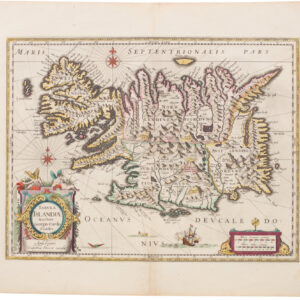
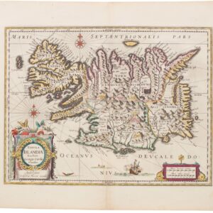
Frederik de Wit’s intricate map of Norway in old color.
Regni Norvegia Nova Tabula In Quinque Praefecturas Generalis Aggerhusiensem, Bergensem, Nidrosiensem, Warhusiae Et Bahusiae
Out of stock
Description
Frederik de Wit was one of the greatest cartographers of the 17th century and a key figure of the Golden Age of Dutch cartography. This is his detailed map of Norway: the most bountiful province in the Kingdom of Denmark.
When De Wit produced this incredibly detailed map, Norway was an integrated, albeit rural, part of the Kingdom of Denmark. Norway supplied most of the kingdom’s natural resources – from timber and fish to building stone and blubber. De Wit’s engraving provides a highly detailed and tight rendition of the country. Denmark is not included in the map (but received its own dedicated sheet), just as very little of the Swedish mainland has been included. In this sense, it shows that even in the mid-17th century, a clear idea existed of Norway as a distinct region.
As we follow the contours of the coast northwards, we are struck by a sense of the extraordinary beauty that Norway boasts, with its countless deep fjords and rugged granite shoreline. Toponyms along the coastline are considerably denser than inland, correctly reflecting how and where people settled. In addition to the natural resources the Norwegian wilderness provided, the land was inhabited by people skilled at all things nautical. Many great Viking explorers sailed from Norway, and Norwegian fishermen and whalers first sailed on the dangerous Arctic coasts of Greenland.
Along the western coastline, we find many of the critical coastal centers that still constitute Norway’s most important cities today. The great Stavanger and Hardanger Fjords are depicted in incredible detail, although not always geographically exact. In addition to the administrative capital at Kristiania (later Oslo), the most important Norwegian city at this time was Bergen: a trade hub for commodities like whale blubber, tar, and timber, which lay shielded in its elongated fjord on the west coast, just north of the Hardanger Fjord. On the south coast, at the northern end of the Oslo Fjord, we find the Norwegian capital of Kristiania (later Oslo). On the city’s western flank, we see the great castle of Aggershus (Akerhus), which functioned as a residence during royal visits and was the most important strategic stronghold in Norway at the time.
The map includes plentiful details on the landscape and topography, and De Wit plots all major towns and cities (i.e. Bergen, Stavanger, Kristiania, and Frederiksstad) with urbis symbols painted in red. In the upper right corner, we find an inset of Arctic Norway, the so-called Finmarken, and in the lower right corner of the map, we find an elaborate cartouche sporting the triple lion heraldry of the Danish Crown.
Cartographer(s):
Frederick de Wit (1629–1706) was a Dutch cartographer and artist who drew, printed, and sold maps from his studio in Amsterdam. He was a pioneer of Dutch Golden Age cartography, and the founder of one of the most famous map-publishing houses in Amsterdam. He was born in Gouda but moved to Amsterdam at the end of the Thirty-Years-War (1618-48), which had engulfed most of Europe and ultimately liberated the Netherlands from centuries of Spanish dominion.
Soon after arriving in Amsterdam, probably in 1654, De Wit opened a printing shop named The Three Crabs (De Drie Crabben). A year or two before, he had married Maria van der Way, the daughter of a wealthy Catholic merchant, and this may have helped secure the funding to start his new operation. His aspirations as a cartographer were nevertheless made clear when he shortly after changed the name to The White Chart (Het Witte Pascaert), under which he gained international renown.
In the latter half of the century, De Wit began drawing, copying, and publishing atlases and maps. By the 1670s he was issuing large folios with up to a hundred maps in each tome, including a famous nautical atlas in 1675. From 1689, De Wit received a state privilege from the Dutch government to draw and issue maps. This protected his work from the illegal copying known from his earlier charts. De Wit was among the first to apply extensive coloring and his original color atlases and continental charts remain highly sought after to this day.
Following De Wit’s death in 1706, his wife ran the business for four years before selling it at auction in 1710. Their only surviving son was a successful merchant in his own right and had no interest in taking over. At the 1710 auction, most of De Wit’s plates were sold to Pieter Mortier, another Amsterdam cartographer and engraver. After passing the firm to his son, who teamed up with Johannes Covens, the firm became Covens & Mortier, the largest cartographic publisher of the eighteenth century.
Condition Description
Various repairs and infill, and other blemishes. Nice old color.
References