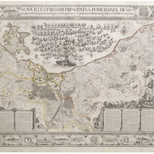
Waghenear’s gorgeous 16th-century sea chart of Sweden’s Baltic coastline.
De Custen van een deel van Denemarken en Swederijck, beginnede va Vuijtste to Calmer Toe…
$900
1 in stock
Description
Lucas Janzoon Waghenaer’s exquisite sea chart of Sweden’s southeastern Baltic coast boasts a number of remarkable features, including two ornate cartouches and a striking 32-point compass rose at the center of the composition. The map is adapted to suit the local geography, which explains why it is oriented with north directed towards the top right corner. Essentially, the subject is the section of the Baltic littoral known as Hanøbugten (Bay of Hanø), with the island of Hanø prominently (but erroneously) placed between the coastal towns of Santhamer (Sandhammer) and Somerhauen (Simrishamn).
The map covers the southeastern coast of Sweden, which at the time it was rendered, constituted part of the Kingdom of Denmark. At the western edge, we find the eastern part of the Skåne region, which still is tied closely to Denmark today. Following the coastline, we find well-known Swedish towns like Åhus and Kalmar. More obscure locations, such as Sandhammer (Santhamer) on the southern tip of Sweden, are also shown. Within the maritime sphere, the map is also well-defined in that it covers the part of the Baltic Sea that stretches from eastern Bornholm to the southern half of Öland, both large and well-known islands in the Baltic Sea. Interestingly, and revealing the innovative nature of Waghenaer’s sea charts, we find brief descriptions and topographic coastal profiles of Bornholm, Ertholmene, and Öland along the top.
The map was designed to provide mariners and navigators with an accurate and expansive view of the nautical landscape in this region. As is common in Dutch maps of the 16th century, the chart offers a wealth of intricate cartographic and pictorial details. Being designed as a sea chart, soundings, sandbars, anchorages, coastal towns, and topography have all been meticulously rendered.
A range of embellishments enhance the map’s allure further, including a gracefully illustrated ship at full sails and three horrifying sea monsters. On land, we also find an assortment of animals, including a wild hog, a fox, and a goat, which both add to the enchanting visual narrative, but also reflect some of the merchandise offered locally (e.g. furs, tusks, and salted meats and fish).
On the verso of the map is the original Latin text, which provides some additional context and information on the region in question. Importantly, this text also notes that the meticulous engraving was done by the extremely talented Joannes Doetecum, who also worked as the engraver for eminent Dutch artists like Pieter Breughel the Elder and Hieronymus Bosch. We also find Doetecum’s imprint and privilege within the carefully crafted scale cartouche.
Verso text: Latin.
Cartographer(s):
Lucas Janszoon Waghenaer (c. 1534–c. 1606) was a Dutch cartographer, known for his pioneering contributions to nautical geography and mapmaking. Part of his success as a mapmaker hinged on his personal experience at sea. For almost thirty years he served aboard ships, starting as the decoy, but soon working his way up to chief officer and sailing on most of the major ports of Europe. After retiring from a life at sea, he began compiling maps, publishing his first major work, Spieghel der zeevaerdt (Mariner’s Mirror), in 1584. This was a distinctly nautical atlas, and something the world had not seen before. It attained huge popularity and was followed by another two nautical atlases in 1592 and 1598.
Despite the success of his volumes, he died in poverty.
Condition Description
Excellent, crisp impression on heavy paper. Reinforced centerfold; small tear in margin of upper right corner.
References
Related products
-
-
Add to cart


- Europe, Italy, Bird's-eye-views
Venetia.
- $3,500
-
-
-