A rare and spectacular vision of ancient Rome, compiled by a German scholar in the mid-19th century.
Roma Vetus In usum scholarum editit Herm. Rheinhard Tymn Stuggt. Prof.
$2,400
1 in stock
Description
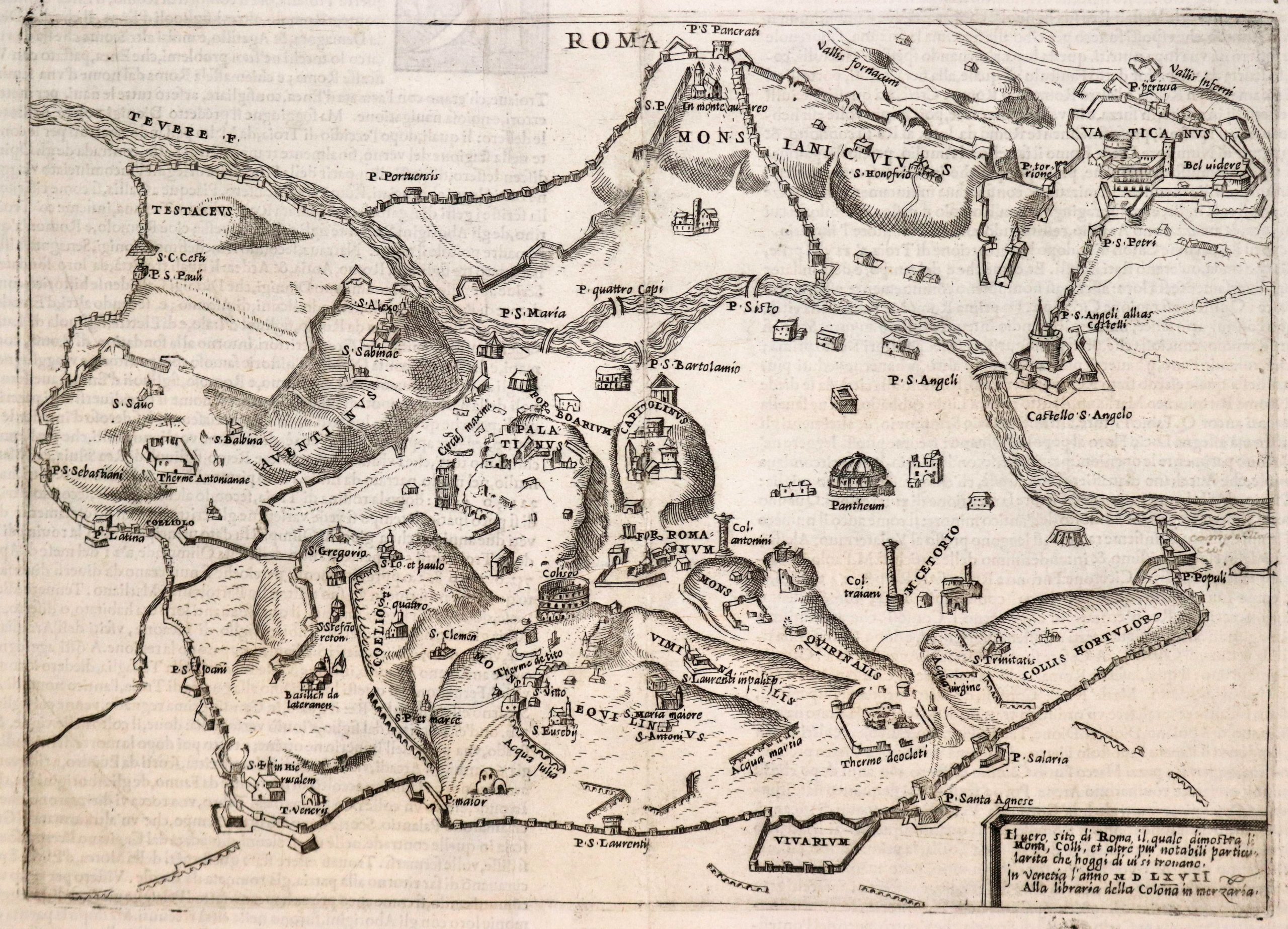
This fascinating folding wall map of ancient Rome was published in 1868 by Hermann (Arminius) Rheinhard, a German antiquities professor based in Stuttgart. It is a special, separate issue of a smaller atlas map produced by Rheinhard in 1860.
An elegant title page has been added to the verso of the linen backing, which not only identifies the map and its maker but also informs us that the new version was funded (sumptibus) and possibly published by one C. Hoffmann, also of Stuttgart.
Characteristic of the retrospective outlook of the map, the labels and title are in Latin. The map shows all of ancient Rome’s famous institutions and monuments. Surviving complexes such as the Baths of Diocletian or the Colosseum (Amphithetrum Flavium) are shown in considerable plan detail, whereas other institutions now in ruins are outlined and shaded.
On the left is an inset plan of the Forum, which shows all of its individual features in detail. A similar plan was found in the lower right corner of the original atlas map. A completely new decorative element is the insertion of ten finely engraved vignettes in each corner of the map (two in the top corners, three in the bottom). These depict some of the Eternal City’s most famous landmarks as they appeared at the time (i.e. in a romanticized and largely ruinous state).
The urban landscape is set within the broader scope of Rome’s natural topography, which the mapmaker carefully renders, labels, and colors as the infrastructure itself, allowing each of Rome’s Seven Hills to be easily distinguished.
Census
This map was originally compiled for a school atlas of the ancient world that Rhienhard published in 1860, entitled Atlas Orbis antiqui. In usum scholarum. Editio quarta emendata et aucta.
It contained twelve original maps, of which most were relatively ordinary compositions of regions in Europe, as well as greater Syria-Palestine. However, in his dedicated plan of ancient Rome, entitled Roma Vetus, Rheinhard applied a more enticing visual, making it by far the most popular map in the atlas. This popularity prompted a separate publication of a revised version of his plan eight years later. The new edition, conceived as a wall map and sold independently from the atlas, included a range of new features.
Even though Rheihard’s atlas received considerable attention and recognition when it was published, it continues to be widely circulated and is easy to acquire. On the contrary, the wall map has become incredibly rare on the open market.
The OCLC lists examples of this map in the British Library (no. 557275173), Boston Public Library, Bibliothèque Nationale de France, Bayerische Staatsbibliothek, and in the university libraries of Harvard, Princeton, University of Amsterdam, University of Zurich, and Oberlin College (no. 163104402).
We have only found a single example brought to market in recent decades. This was sold at an auction at Hôtel des Ventes de Saínt Omer on February 27th, 2016 (lot 123). No estimate or sales price was provided in the listing.
Cartographer(s):
Hermann Rheinhard was a German antiquities professor based in Stuttgart.
Condition Description
Segmented and laid on linen, as issued, with paste down title on outer part of linen. Overall some minor toning and minor loss of linen at one fold intersection.
References
Related products
-
-
Add to cart


- Europe, Italy
A Topographical Map of the Republick of Genoua, Taken from the Celebrated Map by Chaffrion…1764 / To the Right Honourable James Steward Mackenzie, Lord Privy Seal of Scotland, One of His Majesty’s most Honourable Privy Council, and Late His Majesty’s Envoy Extraordinary and Plenipoteniary to the King Of Sardina. This Map is most Humbly Inscribed…
- $4,400
-
-
-