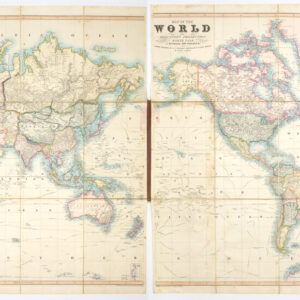
1541 Ptolemaic world map with the name ‘America’.
Orbis Typus Universalis Iuxta Hydrographorum Traditionem Exactissime Depicta. (Tabula orbis cum descriptione ventorum)
Out of stock
Description
This is one of the earliest obtainable world maps to present the word ‘America’ and is highly sought after. This map was originally drawn by Fries who signs “L.F.” in the main title.
The map is crossed by directional lines and framed by a decorative banner with the names of the the winds. England and Scotland are shown as separate islands. India is drawn as a confusing double peninsula.
South America is shown, although largely based upon guesswork, as the remainder of Magellan crew did not return to Europe until September 1522, several months after this map was first published. The current example is dated to 1541 based on the additional title of Tabula orbis cum descriptione.
Shirley sums up the attraction of this map for collectors nicely, noting that it reflects the ambiguities of early 16th century cartography and exploration, “a framework of medieval thinking is having to be re-cast in order to accept the as yet unrealized extent of the newly conquered lands.”
Cartographer(s):
Laurent/Lorenz Fries (ca. 1485-1532) was born in Alsace circa 1490 and studied medicine and mathematics at a number of European universities. He was trained as a physician but was also keenly interested in cartography and medical publications. From 1518-19 Fries is mainly based in Strasbourg, where he was commissioned to compile the first edition of Waldseemüller’s atlas after his death in 1520.
Condition Description
A good example with a few tiny holes restored at centerfold.
References
Shirley, Rodney W. The Mapping of the World: Early Printed World Maps, 1472-1700. London: Holland Press, 1983, #48.