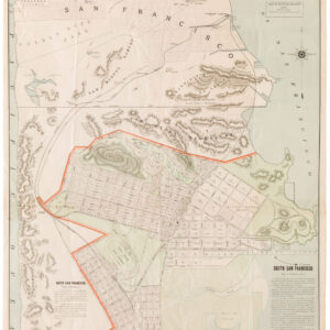
A rarity of San Francisco — unrecorded 1888 precinct map of the Marina and Pacific Heights with mysterious East Van Ness.
41st Assembly District Showing its Election Precincts, City and County of San Francisco
Out of stock
Description
We consulted many colleagues and San Francisco map experts and none have seen this map before, nor do we find record of any institutional holdings. It delineates San Francisco’s 41st Assembly District and its election precincts and extends east-west from Hyde St. to Lake & 8th Ave., and south-north from California St. to the Bay. This includes Laurel Heights, Pacific Heights, the Marina District, and parts of Russian and Nob Hill. The title box is placed in the Presidio.
The map includes a feature we have yet to see on any other antique map of San Francisco: East Van Ness Ave., running from Union & Polk to Lombard & Van Ness. East Van Ness appears in city directories from 1885 through 1894. It was surely a remnant of the famous Laguna Survey, said to have been conducted by Jasper O’Farrell in 1847/8. The survey ran at an odd angle to the expanding axis of the city grid. Eventually it was all but discarded, but this is a fascinating cartographic trace of the survey.
The original northern shoreline of the Bay is shown, showing how much of the Marina is built on landfill. Several spurious street names are shown in this area, including Tonguin and Lewis. These were planned but never actually created; Tonguin street is instead Marina Boulevard and Lewis is Marina Green Drive.
Cartographer(s):
The Dakin Publishing Company was active in San Francisco in the second half of the 19th century and early 1900s, with its main office at 320 Sansome Street.
Condition Description
Soiling throughout and loss in the margins. Professionally restored and backed with archival silk paper.
References
Thank you to Angus Macfarlane for his notes on East Van Ness.
![PORT OF SAN FRANCISCO. WHERE THE FAR EAST BEGINS [Japanese language version]](https://neatlinemaps.com/wp-content/uploads/2021/01/NL-00879_Thumbnail-300x300.jpg)
![[1906 EARTHQUAKE PANORAMA – FINANCIAL DISTRICT]](https://neatlinemaps.com/wp-content/uploads/2020/10/Screen-Shot-2023-02-06-at-6.55.56-PM-300x300.png)

