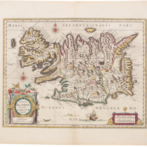
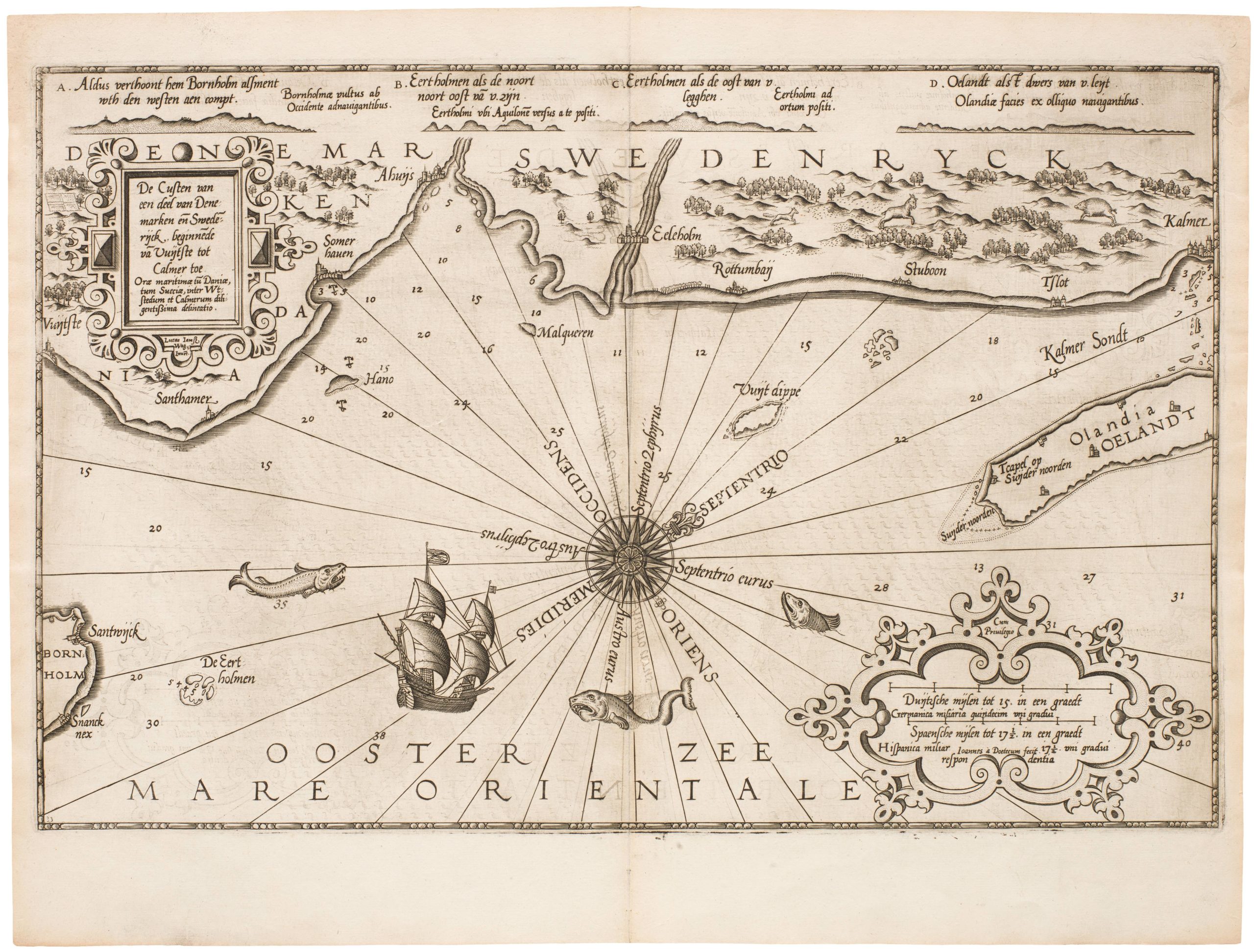
A beautifully preserved example of the most decorative and famous map of Iceland ever produced – with an additional hand-drawn sea-monster on the verso.
Islandia
Out of stock
Description
Abraham Ortelius’ map of Iceland is one of the most famous and collectible early maps in existence. There are many reasons for this, some of which we shall delve into here, but the most crucial aspects to this map’s desirability are its accuracy and its ornamentation, which is nothing short of spectacular. Dramatic features such as sea-monsters were a well-known decorative element in 16th and 17th century maps, but only very few have taken it to the level of Ortelius’ Islandia. The map is famous for them; and this is not just a recent phenomenon. Indeed, the monsters constituted a crucial way of marketing and promoting the map: They invigorate the imagination today — imagine the impact they had five centuries ago!
Islandia was initially published in an addendum to Abraham Ortelius’ Theatrum Orbis Terrarum (Theatre of the World), widely considered to be the first modern atlas in history (i.e. a volume of uniformly sized map sheets with descriptive text and title page). The first edition of Theatrum was published in 1570 to huge public acclaim and a massive ensuing demand. Over the next four decades, the atlas was re-issued in thirty-one distinct editions and translations, the final one being in 1612. Even though the map is dated by Ortelius to 1585 in the upper left corner, the addendum in which it appeared first came with a French edition published in 1587. The addendum contained several new and iconic masterpieces such as the Mare Pacifici and Islandia maps, and quickly became as sought after as the main volume. Neatline’s copy is from the early 1592 version of Theatrum published in Antwerp, as can be verified from the original text on the verso.
Islandia was a defining cartographic moment for the small north Atlantic island. Its appearance in Theatrum placed it definitively into the geographical framework of Europe, as well as into the European imagination. It became part of a greater whole. This is of course an important achievement and milestone, but what is truly remarkable about this map is the chain by which the information was compiled. As we will discuss in more detail below, Ortelius relied on a Danish mapmaker, who in turn drew on a local Icelandic authority’s intimate familiarity with the region. In doing so, Ortelius created a map that on one hand was very modern, in the sense of its accuracy and geographic detail, but on the other, he unwittingly drew on more ancient and esoteric sources than any of his contemporaries by compiling a bestiary from a little known 13th century text.
As if that were not enough, our copy also carries a hand-drawn image of a sea-monster in the lower right corner of the verso, making this a completely unique map. The uniform fading, the style of the beast, and the ink used all suggest that this ‘doodle’ is centuries old, and possibly from the time when this particular chart was issued. While clearly a sketch, the drawing was executed with incredible skill by someone who had clearly drawn these kinds of creatures before, and this personal touch to an already iconic bestiary only makes this particular example all the more desirable.
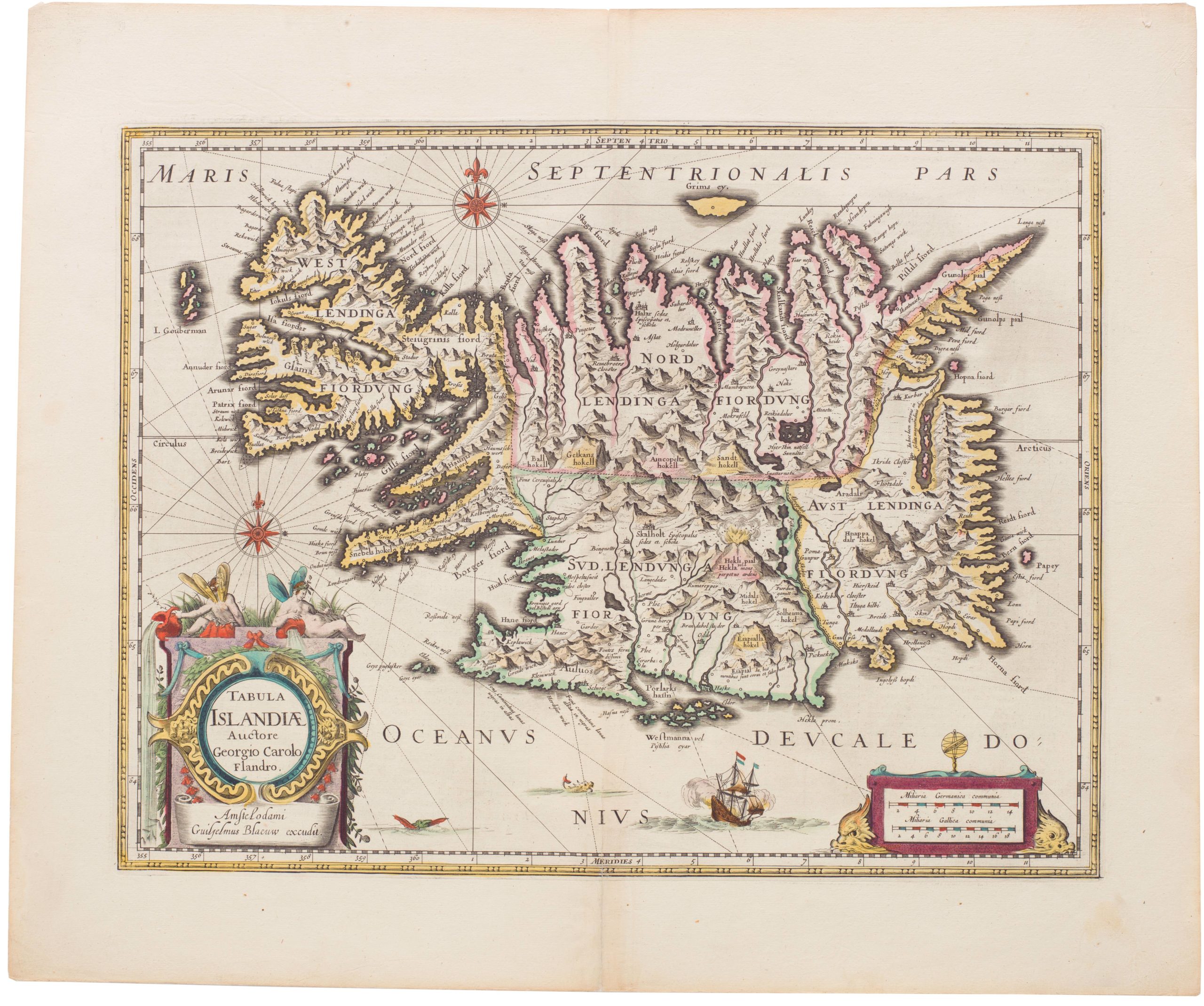
The map is a hand-colored copperplate engraving measuring 34 x 49 cm (13.4 x 19.3 in) and drawn at an approximate scale of 1:1,700,000. Yellow sidebars show the position of the island between 64° and 68° northern latitude, the prime meridian running through western Iceland at the 360°/0° mark (immediately right of the title cartouche). It was supposedly produced by Danish mapmaker and historian, Anders Sørensen Vedel (Andreas Velleius in Latin, 1542-1616), as is noted in the cartouche in the lower right corner. While Vedel undoubtedly provided Ortelius with the prototype map, it is perhaps unlikely that he himself was its author, but to this we shall return.
Islandia is celebrated for its intricate and ubiquitous decoration of both land and water. All manner of creatures have been included, giving it the raw and wild character associated with the antique concept of ultima Thule (although Ortelius in the text specifically denounces this attribution as antiquated). Among the many creatures we find recognizable beasts such polar bears and elk, but most of the bestiary is quasi-mythological, sporting a diverse range of especially sea monsters wherever there was available space.
Let us then take a closer look at some of the many monsters and beasts included on this map. The sea is swarming with menacing looking creatures, most of which have been labeled with a letter that refers back to a legend in the descriptive verso text. The exact sources for these descriptions are further discussed in the Background section below, but a number of specific creatures and their associated descriptions are worth highlighting here.
Beginning with A, located in the upper right side between Grims Island and the ice flows, we find the Nahval or narwhale. Even though it looks more like a beak in the actual depiction, the nahval is described as having a seven-cubit tooth sticking out of its forehead, which mariners have tried to pass off as the horn of a unicorn. While the ‘tooth’ apparently has antidotal qualities, the flesh of this beast is toxic and will kill any person that consumes it.
In the upper left corner we find another seemingly aggressive sea monster. According to the description on the verso, this is a roider, which is an Icelandic term (reyður) for rorqual (B). It is noted as large baleen whale, the meat of which is tasty and the fat of which has many health benefits. An almost identical description can be found in the 13th century Norse manuscript, the King’s Mirror (discussed further in the Background section below). The roider’s counterparts are located at the bottom of the map (H & L). Like the roider, they spew a double stream of water from blowholes in their forehead, confirming their nature as mammals (i.e. whales). The rendition on this map has clearly been taken from Olaus Magnus’s great chart, which depicts especially baleen whales in the same manner.
While the text does not identify monster H by name, we may safely presume that it is the Kraken, known from Sebastian Münster’s Cosmosgraphia and other contemporaneous works (including the 13th century King’s Mirror). Ortelius informs us that the beast is a cunning hunter despite its bulky size and so large that mariners often mistake it for an island. In sharp contrast to this, we learn that the large Steipereidur (L) whale is not just the gentlest of its kind, but that it rises to the defense of sailors being attacked by more aggressive species of whale. It is consequently forbidden for any man to kill or hunt this particular type of whale.
Among the more exotic and strange looking creatures we find the Sea-hyena or Sea-hog (D), which is described as a large fish, but seems is mythological in nature. Below it is the Ziphius (E), a horrible sea monster that is able to devour a black seal in a single gulp. And to the right of this fine pair, we find the Hroshualur or Sea-horse (G): a horrifying composite creature with the upper torso and mane of a horse, the tail of a dragon, and webbed front claws. It is noted as causing great fright and pain among the sailors that encounter it. Finally, there is the Skauthuhvalur (I), which is described as aggressive, covered in bristles, and capable of overturning smaller vessels.
Just north of Westmanna Island, we see two bull-like creatures that seem to be frolicking in the sea. These are Seenauts or sea-cows (K). Occasionally they emerge from the sea to feed on land, but most of the time they remain submerged, surviving by means of a small air pocket under their noses. A seemingly related beast is the Rostunger or Rosmar (N), which is also known as a sea-calf. From the text we may deduce that the creature in question is a walrus, for it is described as walking along the ocean floor on four short legs and having so thick a hide that no weapon can penetrate it. When sleeping, it clings to the rocks by its two long teeth.
The sea also contains other interesting features, such as areas of Hualambur (presumably amber) to the southeast. The entire eastern coastline is characterized by a dense mess of broken logs to the south (P) and large ice flows to the north (Q). This reflects the underlying currents in the Atlantic that push coastal debris south and west. In the description it is noted that the logs are torn by storms from the rugged Norwegian coast and pushed west until they strike upon the Icelandic coast. The inhabitants had relied on this kind of driftwood for construction materials since Iceland was initially settled by Norsemen in the 9th century.
Similarly, a mass of frozen detritus, much of it produced by the glaciers of eastern Greenland one presumes, flows south from the Arctic and strikes Iceland’s northeastern coast, where they fill the fjords with pack-ice. The text notes the horrible noises that the ice creates and emphasizes the enormity of some of the fragments by stating they are ‘marvelously huge’ and up to forty cubits in size. At times, the larger ice sheets ‘support white bears, that sit and play together, or watch the fish swim by’. Obviously, this portrayal relates to the animals growing increasingly desperate for food at the end of the season and hunting from the ice sheaths. The playfulness loaded into the description is, however, also present in the representation of no less than fifteen polar mucking about on the ice flows.
On land, the map is also full of features and creatures that are described in the verso text. As in the sea, some of these are mythical, while others constitute a balancing act between what is real and imagined. Among our favorite inclusions is a depiction of a group of particularly cunning foxes. According to the annotation, they work together to rob the nests along the steep cliff faces of their eggs. In the southeast corner of Iceland, just above the walrus, we find a depiction of these clever devils forming a line down the cliff by biting each other’s tails. At the top, a large fox holds the entire bunch while another keeps a watch out. Exactly how eggs would be retrieved in this manner is unclear. What is clear though, is that it is not an easy task, since two of their compatriots have landed in the icy waters below.
In addition to the extensive bestiary and dramatic landscapes, the map is also full of folklore and brief descriptions of noteworthy places. At Reykjanes, for example, we find statements about two springs, one that turns white wool black, and one that does the opposite. It is also a map in which the great glaciers of Iceland are shown and named for the first time. The most dramatic component of the map is perhaps the Hekla Volcano, who in fiery majesty dominates the center of the island. And even though one is not in doubt as to the violence of its eruption, the depiction is accompanied by a short text in Latin, which recounts Hekla as ‘eternally damned, covered in horrible snowdrifts, and violently expelling large boulders’. This is reinforced visually by means of a massive mountain engulfed in a scorching explosion and capped by a massive ash cloud.
Background
The Islandia map is incredibly accurate and detailed for the age in which it was produced, and which exact sources Vedel used to compile this chart continues to be a subject of considerable debate. It is nevertheless worth noting just how detailed this rendition of the 16th century Iceland actually is. In appreciating this, one must recall the geographic isolation of Iceland, located as it is in the North Atlantic. But Denmark had nourished close ties with Iceland since the Viking Age and the source material that an established Danish historian such as Vedel would have access to may in this particular case have surpassed many archives in the great continental cities.
It is clear from just looking at the map, that its maker was extremely well informed about local conditions and geography. Not only is the topography impressively accurate, but the map is also extensively annotated with mountains, rivers, volcanoes, islands, and settlements all bearing labels. In fact, there are in excess of 250 different locations identified by name on this particular map. A noticeable feature of the Icelandic landmass is the ubiquitous mountains and deep fjords, most of which have been named for the first time. The rendition leaves audiences with the clear impression that the island is mountainous throughout, with fjords reaching deep into the land.
Inspiration for this map was no doubt drawn from the extraordinary Carta Marina compiled by the Swede Olaus Magnus and published in 1539. Magnus’ incredible chart set new standards for cartography in northern Europe and many elements present in his chart were quickly adopted in another great geographical work of the age: Sebastian Münster’s Cosmographia. This book inspired cartographers throughout Europe, including both Vedel and Ortelius, and would have been one of the primary sources used for compiling the bestiary on this map. The rarity of the subject matter, the aesthetic qualities, and the unexpected detail and accuracy are all factors that make this map so very collectible. However, in order to truly appreciate the importance of this chart, it is just as vital to consider the sources used in its compilation. To accomplish this, it is necessary to break down and describe individual components of the map in order to assess where they come from.
While Vedel/Ortelius undoubtedly used Olaus Magnus as the inspiration for the magnificent rendition of sea monsters, the descriptions of them draw on a much wider array of sources, adding to the mystery of how this map was conceptualized and compiled. A very important source in this regard, and one that goes un-noted by Ortelius in his bibliography, is the 13th century Norse book Konungs Skuggsjá (King’s Mirror), which contains a chapter on the Icelandic seas, including descriptions of the mythological creatures therein (Van Duzer 2013:108-10).
The King’s Mirror only existed in manuscript form in Norway until the 19th century and it thus entirely unlikely that Ortelius himself would have had any knowledge of this uncirculated text. As a native historian to Denmark/Norway, Vedel, on the other hand, could perhaps have known about it. But the most likely explanation – and increasingly the academic consensus – is that Vedel had relied heavily on the work of Icelandic bishop and cartographer, Gudbrandur Thorlakson (Guðbrandur Þorláksson, 1541-1627). We know that Thorlakson produced a chart of his native Iceland in 1606, in which he had relied on astronomical measurements to draw some of his conclusions. Sadly, no copies of this map have survived, but it is entirely possible that Vedel simply supplied Ortelius with a copy of this chart.
As the leading intellectual on Iceland at the time, Thorlakson is not just the only known candidate with the necessary skills and knowledge to compile such a detailed and well-informed map of Iceland, but he is also likely to have been familiar with the medieval Nordic texts describing his homeland. These naturally included the sagas, but would also have entailed royal manuscripts such as the King’s Mirror, explaining why Ortelius’ Islandia draws so heavily on it without accrediting it.
The link to Thorlakson is further corroborated by the nature and description of the monsters. If Vedel did provide Ortelius with a chart that he had copied more or less directly from a chart originally drawn by Thorlakson, this would help explain the sheer quantity of topographic and toponymic information conveyed on this chart. It is, however, not just settlements, fjords, and volcanoes that have labeled; many of the beasts have also been provided with Latin or Icelandic nomenclature and descriptions in the verso text. Each of the sea monsters is marked with a number that allows one to consult a description on the verso. Not only does this underline the meticulousness of the compiler, but it also stresses just how symbolically important these creatures actually were.
For almost a century, the Theatrum set new standards for European atlases. It was the first time that so many of the best available maps were redacted to a uniform format and style, and compiled into a single volume. Another innovation was the division into maps and associated textual descriptions. It was this dynamic and fresh approach that made the chart stand out to the degree it did and still does. Apart from being a seminal cartographic achievement that set new standards for the cartography of Iceland, Ortelius’ Islandia is a work of art. It is one of the most decorative and ornamental maps ever produced and an evocative link between Medieval and Renaissance perspectives of the world.
Cartographer(s):
Abraham Ortelius (1527-1598) was born in Antwerp to Flemish parents in 1527. After studying Greek, Latin, and mathematics, he and his sister set up shop as book dealers and a ‘painter of maps.’ In his heart, Ortelius was, nevertheless, first and foremost a historian. He believed geography was the ‘eye of history,’ which explains why he collected maps and historical documents with such passion. Ortelius traveled widely in pursuit of his interests, building contacts with mapmakers and literati all over the European continent.
Ortelius reached a turning point in his career in 1564 with the publication of a World Map in eight sheets, of which only a single copy survives. In 1570, he published a comprehensive collection of maps titled Theatrum orbis terrarum (Theatre of the World). The Theatrum is conventionally considered the first modern-style atlas. It was compiled by collecting maps and charts from colleagues across the continent, which Ortelius then had engraved in a uniform size and style. The engraver for most of the maps in Theatrum was none other than the famous Frans Hogenberg, who also served as the main engraver for the 16th-century urban atlas Civitates Orbis Terrarum, published with Georg Braun in 1572.
Hogenberg’s re-drawn and standardized maps formed the basis of the first atlas in history (even though it was Mercator who was the first to use the term a few decades later). Unlike many of his contemporaries, Ortelius noted his sources openly and in the first edition, acknowledged no less than eighty-seven different European cartographers. This ‘catalogus auctorum tabularum geographicum‘ is one of the major innovations of his atlas. The list of contributing mapmakers was kept up-to-date for decades after Ortelius’ death. In the first edition of 1570, this list included 87 names, whereas the posthumous edition of 1603 contained no less than 183 names.
While compiled by Abraham Ortelius in the manner described above, the Theatrum was first printed by Gielis Coppens van Diest, an Antwerp printer experienced with cosmographical books. Van Diest was succeeded by his son Anthonis in 1573, who in turn was followed by Gillis van den Rade, who printed the 1575 edition of Ortelius’ atlas. From 1579, Christoffel Plantin took over, and his successors continued to print Theatrum until Ortelius’ heirs sold the copperplates and the publication rights to Jan Baptist Vrients in 1601. In 1612, shortly after Vrients’s death, the copperplates passed to the Moretus brothers.
Condition Description
Excellent. Minor blemishes in the margins and along the centerfold.
References
For reliable and up to date information on the editions, translations and variations in which this map exist, please consult https://orteliusmaps.com
van den Broecke, Marcel
(1996) Ortelius Atlas Maps. An Illustrated Guide. Second Revised Edition. Brill Press: Leiden
(2015) Abraham Ortelius (1527-1598): Life, Works, Sources and Friends. Cartographica Neerlandica: Bilthoven
Van Duzer, Chet
(2013) Sea Monsters on Medieval and Renaissance Maps. British Library Press: London