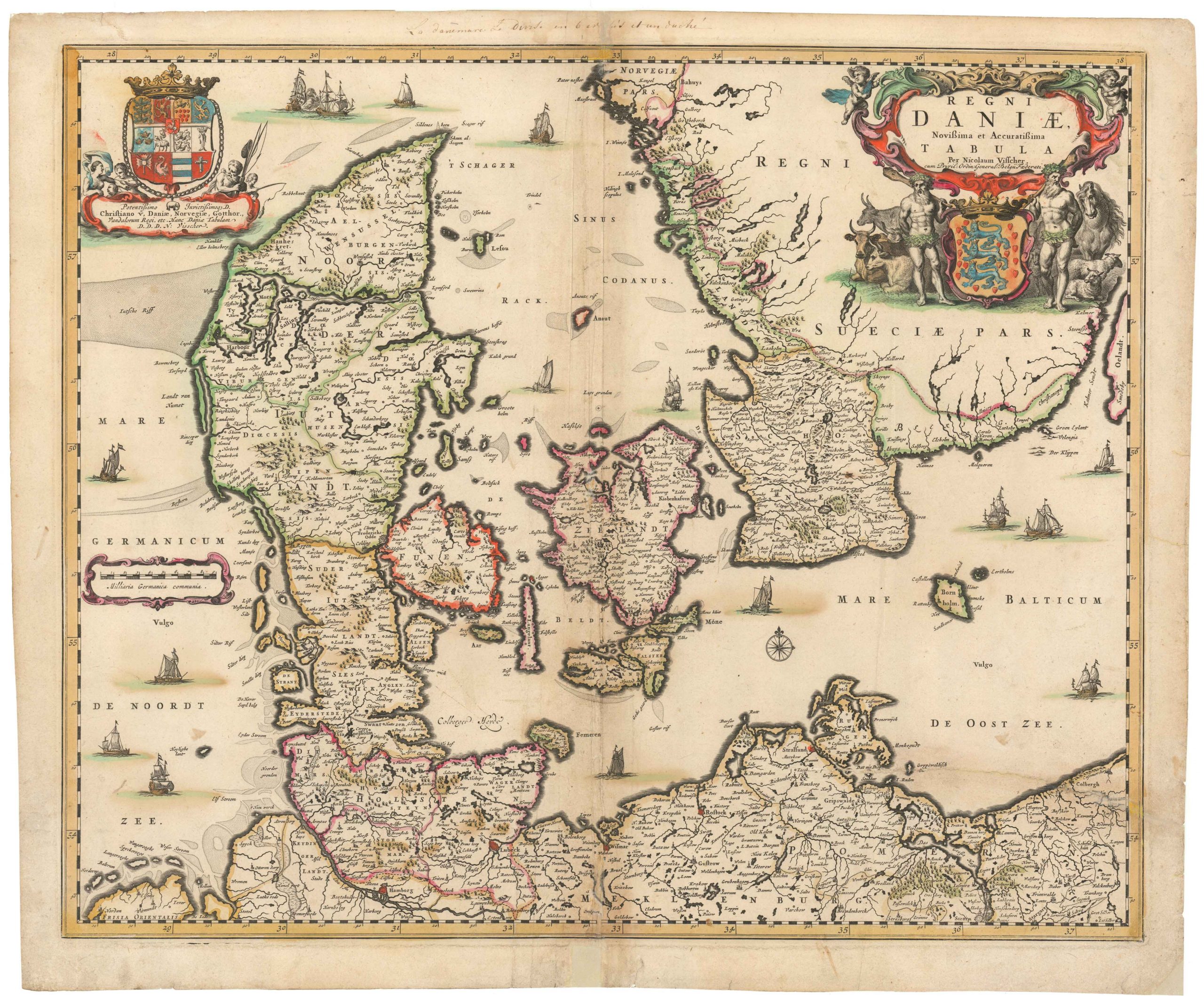
Colonel J.H. Mansa’s wall map of a Denmark reeling from its devastating Prussian defeat.
Generalkort over Danmark
Out of stock
Description
What has been outward lost, must now be inward won.
Enrico Mylius Dalgas on Denmark’s way forward after the defeat of 1864
This wall map of Denmark is a reflection of a crucial but poorly understood moment in the history of Scandinavia. Produced by Colonel J.H. Mansa, one of Denmark’s most competent cartographers of the 19th century, the 1875 Generalkort over Danmark constitutes one of Mansa’s crowning achievements and a cornerstone in his legacy. It was issued as a folding map, sectioned into twenty smaller sheets and mounted on linen. Neatline’s copy is on the original linen and has been well-preserved, considering the objectives and use of this map for educational, surveying, and general display purposes. It measures a total of 58 x 73 centimeters (22.8 x 28.7 inches) and seems to have at one time been displayed and used, judging from the pinholes in the map’s top fringe, as well as the fact that all of the major towns of Denmark have been highlighted by an annotated red dot in pencil.
The map divides Denmark into its constituent parishes rather than the regional distinctions that Mansa had applied in maps prior to this one. This was, however, not unusual for Danish maps of the era and as parishes constituted the formal sub-division of the country prior to the creation of municipalities in the 20th century. We see these subdivisions indicated on the map, and also defined carefully in the two legends, which divide the country into its respective dioceses and their individual parishes.
Among the many initiatives that followed the decisive Danish defeat by the Prussians in 1864 (see Context section below), was a national drive to convert the extensive heath and bog landscapes of Jutland into fertile agricultural land. Consequently, it is not surprising that landscape-types have been carefully included on the map through various forms of etching, dotting or hatching.
Moreover, and complimenting the ambition of more efficient food production, considerable attention was paid to establishing one of the best rural infrastructures of Europe. If Denmark was to be a small country, it would be the most efficiently organized and with the best infrastructure possible. We see this process as being well underway in this map: the Jutland Peninsula, which until the 1860s had been both the breadbasket and the boons of Denmark, is now rapidly developing the necessary infrastructure to integrate it seamlessly with the rest the nation. Roads, tracks, villages, churches, railways and ferries have all been carefully included on the map, so that it in essence could serve as a national travel companion. All of these features are clearly defined in the legend at the bottom of the map, which also provides scale bars for Danish and ‘Geographical’ miles.
Interestingly, the map makes almost no distinction between Prussian territories and Danish ones, especially in the south of Jutland. There is more on this issue on the Context section below, but what is important to note when describing the map itself is the lack of a clear dividing between Denmark and Prussia. The war of 1864 saw much of Denmark reduced, and what in this map has been portrayed rather innocuously as Slesvig, is in fact no longer part of the Kingdom, but had been ceded to Prussia. If one looks carefully, one sees the formal Danish border represented by a dot-and-dash regional dividing line, as if to indicate or commemorate that which had been so unjustly lost. The real border in fact runs just north of the ancient Danish town of Ribe (Ripen) and the Herrnhut town of Christiansfeld.
In the map’s bottom right corner we find a small inset of Bornholm, the Danish island controlling access to the Baltic Sea.
Context is everything
This map was compiled and published in the wake of a national tragedy, in which Danish politicians, consumed by hubris, thought a war with Prussia a good idea. The defeat was total, as was the embarrassment. Not only was Prussia the superior victor, but Denmark lost the crucial continental duchies of Schleswig, Holstein, and Lauenborg, as well as the southern half of Jutland, reducing its landmass by nearly half.
The consequence was not just the loss of significant and rich territories, but a loss of national status, self-esteem, and pride. No longer was Denmark a medium-sized European nation. It had been reduced to an insignificant little monarchy, which despite a glorious past, had little to no influence outside its much diminished borders. This, in turn, had a profound impact on Danish self-perception and self-worth. A deep and tenacious national depression hit the country in the wake of its defeat, and over the coming decades a number of nationalist initiatives were set in motion, with the intention of not only improving the suffering Danish economy, but also to once again bolster the national character and strengthen our resolve and self-esteem.
Cartographer(s):
Jacob Henrik Mansa was a Danish military officer, lithographer, and cartographer. He spent his youth serving as an officer in the Danish Crown’s Regiment, earning commission as lieutenant in 1826 and the rank of captain in 1839. Part of his military career was spent training other soldiers in the art of surveying. From 1848, Mansa was employed by the military’s Central Command as head of the Topographical Section; a position from which he retired with the rank of colonel in 1869 – only five years after Denmark’s devastating defeat by the Prussians.
Between 1837 and 1851, Mansa lead an initiative intended to map all of Denmark at the scale of 1:4000. He lead much of the reconnaissance himself. After 1851, Mansa published a range of Danish maps for a variety of purposes. These included specialized maps of all the Danish provinces, which were broadly acknowledged not only for their accuracy, but for their strong aesthetic. His long career as a military map maker culminated in the creation of two important charts of Denmark: A General Map of Denmark at 1:520000 in 1875 and a school map of the nation in two sheets produced in 1878. These two maps have since come to stand as his most important and lasting cartographic works.
Condition Description
Some wear and light soiling due to use. Pin holes along fringes and a stamp with the name Otto Møller in the lower right edge of the map. In folded state, the linen forming the front has been inscribed ‘Danmark’ in black ink.