To the Edge of the World.
Chart of the World on Mercator’s Projection.
Out of stock
Description
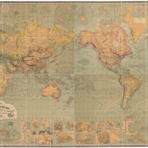
An appealing c. 1850 map of the world employing a Mercator projection that appeared in William and Alexander Keith Johnston’s The national atlas of historical, commercial, and political geography. It is a fine representation of contemporary geographic and navigational knowledge that also hints at future discoveries to be made in the Arctic and Antarctic.
Centered on the Pacific Ocean, the map outlines continents in hand color, with Eurasia divided at the Ural Mountains and with Indonesia and the Philippines lumped in with Oceania. Individual countries and regions are named but not outlined, allowing for the inclusion of cities, rivers, and mountains. The voyages of Christopher Columbus, James Cook, John Ross, and William Edward Parry with their dates are tracked across the oceans. Descriptive text at bottom-left explains how the bearings between two points on the map can be determined using the one of the nine compasses provided.
A profusion of islands in the Pacific are labeled, reflecting the discoveries of the late 18th and early 19th century, while the geography of the Arctic and Antarctic remains fairly uncertain, including a presumed continuous coastline between Greenland and the Qikiqtaaluk Region of Nunavut. Recent discoveries by the United States Exploring Expedition of 1838-1842, led by Lieutenant Charles Wilkes, and the British (James) Ross Expedition (1839-1843) are recorded in Antarctica.
Cartographer(s):
William and Alexander Keith Johnston were Scottish brothers based in Edinburgh who operated a prominent map engraving and printing business in the mid-19th century. A.K. Johnston was the driving force behind the business and remained in the world of cartography throughout his life, while William later entered politics, serving as the Lord Provost of Edinburgh and being knighted for his service. Johnston’s maps and atlases earned high praise for their accuracy and comprehensiveness (A.K. Johnston was strongly influenced by Alexander von Humboldt).
Condition Description
Toning along edges. Light foxing on verso.
References