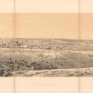
19th-century view of Jerusalem’s Golden Gate.
Eastern View of the Golden Gate.
Out of stock
Description
This plate shows the Golden Gate as seen from the exterior of the Old City, looking southwest. Also known as the Gate of Mercy or Gate of Mary, this is the only eastern gate that accesses the Temple Mount directly and one of only two gates along the entire east side of the Old City. The gate has been sealed off since the Middle Ages, but its interior can still be accessed via the Haram al-Sharif. When viewed from the exterior, as in this lithograph, it is evident that ground levels have risen so much that only the double-arched and pillared niche on the upper tier remains visible. The actual entryway to the gate itself is already long buried in this view and continues to be today.
In Jewish tradition, the Messiah will enter Jerusalem through this gate, coming from the Mount of Olives, whereas some Christians hold that this was the location where Mary’s parents, Anne and Joachim, met following the annunciation when Mary learned of her future son. Consequently, the gate has become a symbol of the immaculate conception.
Interestingly, we get an impression of Pierotti’s insight into the ancient city’s architectural history in that he more or less accurately is able to identify building elements belonging to different periods. This is indicated in the numbered legend accompanying the plate, which lists six distinct elements in the view:
1. Stones of the time of Solomon.
2. Wall of the time of Sulyman.
3. Wall of the time of Justinian.
4. Golden Gate, closed with a native Wall.
5. Modern Mohammedan Tombs.
6. Inclination of Mount Moriah.
Publication information
In 1864, the same year that the first British Ordnance Survey of Jerusalem was commissioned, Italian engineer Ermete Pierotti published Jerusalem Explored, a seminal work on the history, archaeology, and architectural history of the ancient and holy city. This work included Pierotti’s notes and insights after years of surveying and mapping under Ottoman authority. The publication was divided into a text volume and a volume of plates. The latter included 63 lithographs showing everything from strategic views, across architectural plans and section profiles, to panoramic vistas of the Old City. Most of the lithographed plates were based either on photographs or drawings made by Pierotti and his team.
The plates were lithographed mainly by Thomas Picken of London and printed by the prominent British lithography firm William Day & Sons.
Cartographer(s):
Ermete Pierotti (1820-1880) was the oldest of nine siblings in a family from Pontardeto in Pieve Fosciana (the family built the Palazzo Pierotti, which has served as the town hall since 1877). Pierotti worked as a military engineer in Genoa and later served as a captain in the Engineering Corps of the Sardinian King. In 1849, he was accused of desertion and the theft of 3596 lire from the troop’s treasury, which resulted in a dishonorable discharge from the army. Pierotti then traveled to Jerusalem and Egypt, where he worked as an engineer. In Egypt, he discovered the foundations of the Alexandria Library while laying the foundations for a Greek church, but it was in Jerusalem that he would put his surveying and engineering skills to work.
Pierotti arrived in Jerusalem in 1854 as a consultant for the Franciscan Order, which had custody of many of the Christian holy sites in the city. During his time there, Pierotti was involved in the restoration of the Crusader Era Church of St. Anne, located in the Old City near the Pool of Bethesda. Working with Ottoman engineer Assad Effendi, he later contributed to the restoration of the Qanat as-Sabil, the main aqueduct that supplied Jerusalem with water, which involved repairing the aqueduct’s channels and cisterns. Other building projects included work on the Temple Mount itself and the construction of both the Austrian Hospice and the so-called Alexanderhof (HQ of the Kaiserlichen Orthodoxen Palästina-Gesellschaft) in the Christian Quarter of the Old City. And finally, he helped design the road from Jaffa to Jerusalem, a significant engineering feat at the time.
Pierotti became interested in the city’s history and archeology during his time in Jerusalem. He conducted several excavations in the Old City. He discovered several important artifacts, including an inscription in the Church of the Holy Sepulchre that proved the existence of a church on the site during the Byzantine period. Pierotti’s work in Jerusalem earned him a reputation as a skilled engineer and pioneering archeologist. He became known for his attention to detail and ability to work under challenging conditions. In addition to his many projects, Pierotti’s legacy consists of publishing his magnum opus: Jerusalem Explored. A Description of the Ancient and Modern City (1864), which included an entire volume of lithographed plates based on Pierotti’s plans and converted photographs.
Despite his many successes, Pierotti’s work and position annoyed the British, who increasingly sought to establish a scientific presence in the Holy City, if not a colonial one. When competition arose between Pierotti and Captain Charles Wilson’s team of English Royal Engineers conducting the first Ordnance Survey of Jerusalem and surroundings in 1864, Pierotti’s reputation was deliberately tarnished by the disclosure of his criminal past, and for the rest of his life, he struggled to regain recognition for his achievements.
Condition Description
Excellent.
References
![Emigranter till det nya Jerusalem, Frälsarens Kungliga Linie [Emigrants to the New Jerusalem, the Savior’s Royal Line].](https://neatlinemaps.com/wp-content/uploads/2026/04/NL-02567_thumbnail-300x300.jpg)
![[ALEPPO] Toi qui te plains de l’infortune, Lève-toi et va vers… ALEP… Comme le malade épuisé. Soupire après la guérison.](https://neatlinemaps.com/wp-content/uploads/2024/05/NL-01445-cover_thumbnail-300x300.jpg)