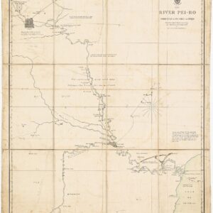
Dépót de la Marine’s seminal chart of New Zealand.
Carte de la Nouvelle Zelande.
Out of stock
Description
This beautiful hand-colored chart of New Zealand was published in 1869 by the Dépót de la Marine in France and depicts New Zealand’s North and South Island in incredible detail. It is one of the first dedicated attempts to produce a modern nautical map focussed on this Pacific island group.
As indicated in the chart’s subtitle, it constitutes a revised state of an original 1864 chart, built on the seven year survey conducted by HMS Achéron and Pandora. The expedition was commanded by Captain James Lort Stokes and Commander Byron Drury of the British Royal Navy, who, between 1848 and 1855, surveyed both the North and South Islands of New Zealand. Once published, the English data formed the basis for a new French chart drawn by V. Carré of the Dépót de la Marine.
We find ample depth soundings along the coast, confirming that this was indeed a chart made from sea to provide a nautical perspective on the islands. Towns and villages are clearly marked and labeled by red dots, and along the coast, we are treated to a wealth of place names for physiographic features like capes, coves, points, and sounds. Further inland, the topography is just as elegantly depicted, with elevations and ranges drawn in and extensively annotated. Major volcanic summits such as Mt. Kaikoura are highlighted and include exact heights above sea level.
Along the coastline of both islands, we find areas highlighted in yellow. These are likely meant to indicate shoals, currents, or other difficult sailing conditions and the need for a local pilot.
The projection is standard Mercator, with corrected graticules along the map’s edge to indicate latitude and longitude. The graticules are among the hand-colored elements of this chart, highlighted as they are in bright yellow and red. Compass needles are provided at certain interstices in the ocean surrounding the two islands, showing the magnetic declination from that exact point.
Census
This map was drawn by V. Carré of the Dépót de la Marine. The original map was published in 1864, whereas Neatline’s sheet constitutes an updated state from 1871. A brief text below the map’s title explains the basis for an initial update in 1869. Below the lower graticule, we find an additional note that other essential corrections were made between 1869 and 1871.
Our chart carries the original Dépót de la Marine number 2136 with an additional serial number that probably was added to the updated 1869 version of this chart (139-190).
While we have not been able to identify exact examples of this chart, in 1865, George Henry Richards published a pilot for New Zealand in French based on the same surveying data entitled Le Pilote de la Nouvelle-Zélande, d’après les travaux exécutés par les navires de S.M.B. “l’Achéron” et “La Pandora”, capitaine J. Lort Stokes et commander Byron Drury (OCLC 759636532). The original British survey map from 1856 (OCLC no. 949720178) can be accessed through the National Library of New Zealand (https://natlib.govt.nz/records/40311716).
V. Carré was a French marine cartographer working for the French Dépót de la Marine during the latter half of the 19th century.
Cartographer(s):
The Service Hydrographique de la Marine was a French governmental agency responsible for hydrographic surveys and the production of nautical charts. Established in the 18th century, it played a vital role in maritime navigation and safety by providing accurate maps and data about the sea and coastal areas.
This organization, which can be translated as the “Naval Hydrographic Service,” was tasked with charting the seas, including the depth of waters, the location of hazards, and other critical information necessary for safe maritime navigation. It was an important part of France’s efforts to improve and maintain its naval capabilities, especially during the age of exploration and colonial expansion.
The work done by this service was crucial for explorers, merchants, and naval vessels, as it allowed them to navigate more safely and efficiently. The accurate charts and maps produced by the Service Hydrographique de la Marine were used not only by French sailors but also had a broader impact on global navigation and cartography. Over time, similar hydrographic services were established in other countries, reflecting the growing importance of systematic and scientific approaches to oceanic mapping.
Condition Description
Wear along edge, with one large bend and smaller chips. Nice, thick paper. Watermark for Service Hydrographique in bottom margin.
References