A fantastic hand-drawn World War I curiosity.
L’instanté de l’Europe et de l’Asie mineure, 1914.
$1,250
1 in stock
Description
A French redrawing of a German satirical map from the Great War. The original is rare; this example is one-of-a-kind.
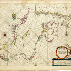
The present manuscript map of Europe and Asia Minor constitutes a 1954 French redrawing of an iconic German propaganda map from World War I (Momentaufnahme von Europa und Halbasien 1914). The original map, Momentaufnahme von Europa und Halbasien 1914/15 (Snapshot of Europe and Asia Minor 1914/15), presents Europe at the outset of World War I through political and military caricature. Each country is personified according to contemporary stereotypes, national symbols, or perceived wartime roles.
Thus, Great Britain appears as a man accompanied by a bulldog and a striking snake, while Belgium is depicted as a crushing fist. France is an infantryman fleeing incoming artillery fire, while Germany is a leaping figure accompanied by a predatory eagle. Austria is represented by a lion operating an artillery piece, flanked by the Habsburg double-headed eagle. Russia is depicted as a large bear, with wolves nearby, set amid scenes suggesting internal unrest. Spain and Morocco are shown as sleeping men, and Italy as a partially nude, sleeping woman. Ireland, the Netherlands, and Scandinavia appear as civilians, whereas Finland, Portugal, and the Adriatic regions are shown as a variety of soldiers.
The map also incorporates visual wordplay, including place-names rendered as puns on German toponyms, and numerous textual labels across surrounding seas and regions that invoke themes such as liberty, revenge, neutrality, death, and diplomacy (e.g., Mord See for the North Sea or Tod See for the Baltic). The original map also included references to the Hague Peace Treaty of 1900. Printing and censorship information from Hamburg publishers Graht und Kaspar is included, underscoring the work’s origin and wartime context.
Our French manuscript edition
This French-language version, titled Instantané de l’Europe et de l’Asie mineure 1914, is a direct adaptation of Kaspar’s original lithograph. The caricatures and personified nations relating to WWI remain largely the same as on the German original, despite being done in French. The pro-German sentiments of the map are evident in the depiction of a France filled with soldiers fleeing German artillery.
The map measures approximately 65 by 50 cm, corresponding roughly (though not precisely) to the proportions of Kaspar’s original lithograph (73 × 54 mm). It uses watercolor or gouache on a thick carded paper, with a beige base layer to create an aged parchment effect. While the colors of our French version do not contrast as sharply as those in the lithograph, the palette includes orange-browns for Central Power territories, blue for seascapes, and details in red, black, and yellow. The irregular edges suggest hand-trimming and minor wear, consistent with a unique manuscript copy. The handwritten script employs a consistent cursive style, slightly uneven due to manual execution. The French title is set in the upper left corner, just like the original. In the lower right corner, we find the copyist’s signature and a date: S. Romerio – Jane. 54. The author acknowledges the original with a “d’apres W. Kaspar”.
Pictorially, this manuscript copy is very similar to the original. While France is fearful and Russia is a bear threatening Europe from the east, Germany and the Austro-Hungarian Empire are personified as regal and predatory figures, such as the two-headed eagle and a lion. In the collapsing Ottoman Empire, the imagery hints at internal strife in both the Levant, Greater Macedonia, and Thrace. Perhaps the most important indicator that the artists behind this map copied the German original rigorously is found in the labelling of naval spaces: Mer de la Pitie for the Mediterranean; La Mer Fatale for the Black Sea; Lac Mort for the Baltic Sea, and Le mer des scandales for the English Channel.
Context is Everything
Origins and Early Development of Satirical Maps
Satirical pictorial maps of Europe trace back to medieval anthropomorphic cartography, such as Opicinus de Canistris’s 14th-century allegorical designs and Johannes Putsch’s 1537 depiction of Europe as a queen (Europa Regina). The modern tradition crystallized in the 19th century amid political upheaval, evolving from 17th-century Dutch carte-à-figures (decorative border vignettes) and early 1800s humorous broadsides like Laurie & Whittle’s A Whimsical Map of Europe (1806). Between 1848 and 1870, the genre matured with artists like Paul Hadol (Nouvelle Carte d’Europe, 1870), who caricatured nations as human or animal figures, distorting their shapes to embody leaders or stereotypes. This was not least due to the era’s militarized conflicts (e.g. the Crimean War) and Franco-Prussian tensions.
Peak and Application
These maps peaked as affordable, standalone prints sold by street vendors across Europe. We know of examples appearing in French, English, German, Italian, and Dutch, often with a blatant national bias and marketed as drolatique or serio-comic entertainment for all social classes. Such maps nearly always concentrated on Europe due to its volatile alliances and nationalism, and were often used to mock power dynamics. Consequently, Britain was often depicted as a lion, a bulldog, or a whale; Russia as a bear; and Germany/Austria as predatory birds. The most iconic of such maps was probably those compiled by Fred W. Rose, including his seminal Angling in Troubled Waters (1899). Rose and others pursued this style of cartography into the early 20th century, with WW1 reviving the trend in an even more explicitly propagandistic format. W. Kaspar’s original 1915 map belongs to that sub-category.
Decline After 1945
After World War I, the tradition waned as propaganda shifted to photography and text-heavy posters, though reprints continued to appear into the 1930s-1940s. Once World War II got underway, the tradition had largely ended, having been supplanted by more modern media. The tradition’s last echoes were in mid-20th-century adaptations or retrospectives, such as the present manuscript redrawing.
Cartographer(s):
Condition Description
Good. Printed on cardboard-like material. Wear at the corners and some surface abrasion.
References