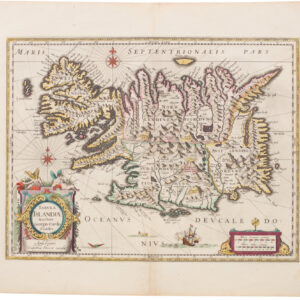
Discover the strategic and navigational significance of the 16th-century Azores with Ortelius’ beautiful 1584 map from the famous Theatrum Orbis Terrarum.
Acores Insulae.
$950
1 in stock
Description
Ortelius’ map of the Azores is a significant cartographic work highlighting the strategic importance of the islands during the 16th century. This map reflects the islands’ intense commercial and navigational activities, crucial for explorers and early commercial mariners.
Historical Context
The Azores were known to Europeans in the 14th century and appeared in the groundbreaking Catalan Atlas. However, they were not “rediscovered” until the early 15th century. The Portuguese navigator Diogo de Silves provided the first reliable account of contact with Santa Maria and Sao Miguel in 1427. Gonçalo Velho Cabral documented his landing on the islands in 1432. The first modern colonization began in 1439.
The Azores played a vital role in transatlantic crossings from the earliest explorations. Christopher Columbus stopped in the Azores in 1493, where he was briefly arrested as a pirate until the legitimacy of his voyage was established. The islands’ strategic importance is evidenced by repeated Spanish attempts to seize them under King Philip II. The Azores were the last part of the Portuguese empire (other than Macau) to resist his reign. The islands were a major port of call for the Spanish Galleon trade during the Spanish occupation.
Cartographic Significance
Marcel Van Den Broecke credits Luís Teixeira’s 1582 single-sheet map of Terceira, which bears Ortelius’ name, as the primary source for Ortelius’ map. Meurer mentions copies of this map at the Bibliothèque Nationale in Paris and the city library of Cologne, along with a later manuscript map of the entire group of islands, to which Teixeira subsequently devoted an atlas.
Ortelius’ map was first issued in an edition of 100 examples in the Additamentum to the 1583 edition of Theatrum Orbis Terrarum. This work is widely recognized as the first modern atlas and a landmark in the history of Western mapmaking. Beginning in 1570, Abraham Ortelius and his successors published and continuously added to this monumental work for over 40 years, with text on the verso in Latin, Italian, German, Dutch, French, Spanish, and English.
Map Features
Ortelius’ map of the Azores includes notable features:
- The islands are shown with their towns and settlements: Cuervo, Las Flores, Fayal, Graçiola, St. George, Pico, Terceira, St. Michael, and St. Maria.
- Two large sailing ships and a sea monster occupy the waters of the Atlantic.
- The map’s title is enclosed in a large oriflamme.
- A large cartouche in the bottom left corner, garlanded by fruit and ribbons, describes the map’s sources.
Ortelius credits the Jesuit Portuguese cartographer Luís Teixeira with mapping the islands in 1584, the year this plate was first published. Teixeira’s most outstanding cartographic achievement was his survey of Japan, also published by Ortelius. This survey became the standard reference for Japan until Martino Martini’s 1655 map.
Strategic Importance
The Azores were an essential hub for the Spanish Americas and the Silver Fleet during the 16th century. Columbus’ observation that compass variation was minimal in this region led to some places in the Azores being indicated as the prime meridian. Only in the second half of the 19th century did the prime meridian internationally agree to run through Greenwich.
Overall, Ortelius’ map of the Azores remains an important historical document, reflecting the strategic and commercial significance of the islands during a transformative period in global navigation and trade.
Cartographer(s):
Abraham Ortelius (1527-1598) was born in Antwerp to Flemish parents in 1527. After studying Greek, Latin, and mathematics, he and his sister set up shop as book dealers and a ‘painter of maps.’ In his heart, Ortelius was, nevertheless, first and foremost a historian. He believed geography was the ‘eye of history,’ which explains why he collected maps and historical documents with such passion. Ortelius traveled widely in pursuit of his interests, building contacts with mapmakers and literati all over the European continent.
Ortelius reached a turning point in his career in 1564 with the publication of a World Map in eight sheets, of which only a single copy survives. In 1570, he published a comprehensive collection of maps titled Theatrum orbis terrarum (Theatre of the World). The Theatrum is conventionally considered the first modern-style atlas. It was compiled by collecting maps and charts from colleagues across the continent, which Ortelius then had engraved in a uniform size and style. The engraver for most of the maps in Theatrum was none other than the famous Frans Hogenberg, who also served as the main engraver for the 16th-century urban atlas Civitates Orbis Terrarum, published with Georg Braun in 1572.
Hogenberg’s re-drawn and standardized maps formed the basis of the first atlas in history (even though it was Mercator who was the first to use the term a few decades later). Unlike many of his contemporaries, Ortelius noted his sources openly and in the first edition, acknowledged no less than eighty-seven different European cartographers. This ‘catalogus auctorum tabularum geographicum‘ is one of the major innovations of his atlas. The list of contributing mapmakers was kept up-to-date for decades after Ortelius’ death. In the first edition of 1570, this list included 87 names, whereas the posthumous edition of 1603 contained no less than 183 names.
While compiled by Abraham Ortelius in the manner described above, the Theatrum was first printed by Gielis Coppens van Diest, an Antwerp printer experienced with cosmographical books. Van Diest was succeeded by his son Anthonis in 1573, who in turn was followed by Gillis van den Rade, who printed the 1575 edition of Ortelius’ atlas. From 1579, Christoffel Plantin took over, and his successors continued to print Theatrum until Ortelius’ heirs sold the copperplates and the publication rights to Jan Baptist Vrients in 1601. In 1612, shortly after Vrients’s death, the copperplates passed to the Moretus brothers.
Condition Description
Very good. Old color. Some wear and toning along the centerfold.
References
Related products
-
-
Add to cart


- Europe, Italy, Bird's-eye-views
Venetia.
- $3,500
-
-
-