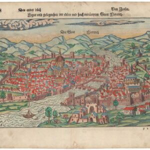
A lovely 16th century woodcut of Pavia, Italy.
Paphy / Papia (Thurin on verso).
Out of stock
Description
An exciting view of Pavia in southwestern Lombardy prepared by Sebastian Munster in 1567 for his Cosmographia.
Pavia is an ancient town some 35 kilometers south of Milan that played an essential role in the Middle Ages and early modern period. The University of Pavia was founded in 1361, making it one of the oldest in Europe and arguably the world. The city saw other new structures and development during the Renaissance era and was quite cosmopolitan (including an established Jewish community), thanks partly to the university. In the years before this map’s production, the city was fought over in the struggles between the Habsburg Holy Roman Emperors and their rivals, including the Papacy, explaining the prominent fortifications seen here.
Below the map and on the verso is a description of the city, while the verso also includes a small view of Turin and an accompanying description.
This woodcut appeared in the 1567 German edition of Munster’s Cosmographia.
Cartographer(s):
Sebastian Münster (1488-1552) was a cosmographer and professor of Hebrew who taught at Tübingen, Heidelberg, and Basel. He settled in Basel in 1529 and died there, of the plague, in 1552. Münster was a networking specialist and stood at the center of a large network of scholars from whom he obtained geographic descriptions, maps, and directions.
As a young man, Münster joined the Franciscan order, in which he became a priest. He studied geography at Tübingen, graduating in 1518. Shortly thereafter, he moved to Basel for the first time, where he published a Hebrew grammar, one of the first books in Hebrew published in Germany. In 1521, Münster moved to Heidelberg, where he continued to publish Hebrew texts and the first German books in Aramaic. After converting to Protestantism in 1529, he took over the chair of Hebrew at Basel, where he published his main Hebrew work, a two-volume Old Testament with a Latin translation.
Münster published his first known map, a map of Germany, in 1525. Three years later, he released a treatise on sundials. But it would not be until 1540 that he published his first cartographic tour de force: the Geographia universalis vetus et nova, an updated edition of Ptolemy’s Geography. In addition to the Ptolemaic maps, Münster added 21 modern maps. Among Münster’s innovations was the inclusion of map for each continent, a concept that would influence Abraham Ortelius and other early atlas makers in the decades to come. The Geographia was reprinted in 1542, 1545, and 1552.
Münster’s masterpiece was nevertheless his Cosmographia universalis. First published in 1544, the book was reissued in at least 35 editions by 1628. It was the first German-language description of the world and contained 471 woodcuts and 26 maps over six volumes. The Cosmographia was widely used in the sixteenth and seventeenth centuries and many of its maps were adopted and modified over time, making Münster an influential cornerstone of geographical thought for generations.
Condition Description
Light soiling in margins and small chips along edge.
References