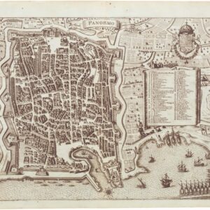
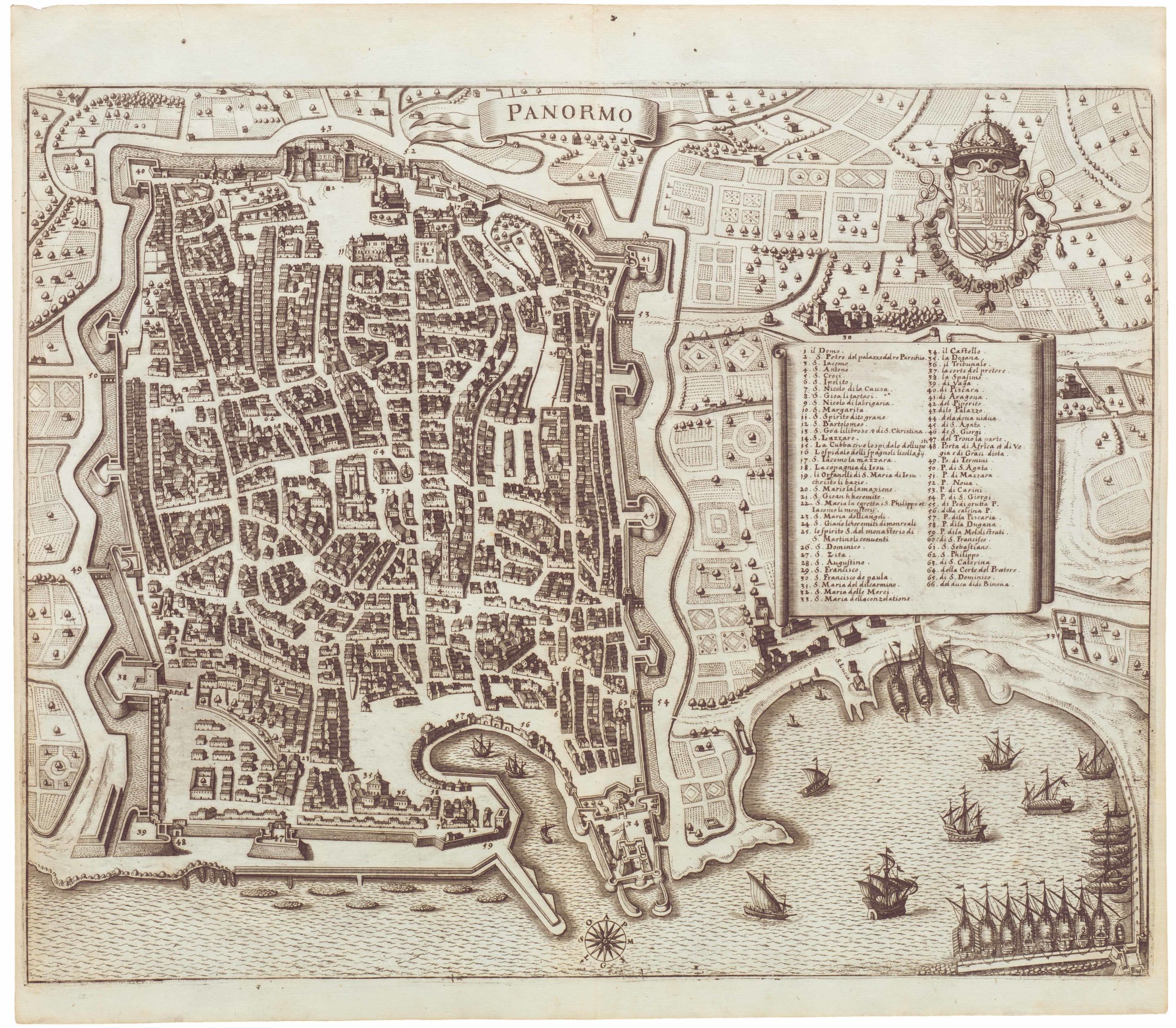
The first printed plan of Palermo, Sicily.
Palermo Città Principalissima nella Sicilia.
$2,900
1 in stock
Description
A masterpiece of Italian Renaissance urban cartography.
This magnificent 1580 view-plan of Palermo is the first large printed map of the Sicilian capital, designed by Orazio Maiocco, engraved by Natale Bonifacio, and published in Rome by Claudio Duchetti. Oriented with south at the top, the map adopts a sea- and harbor-viewpoint, a perspective that would dominate depictions of Palermo for centuries. The city’s powerful maritime role is vividly expressed in the busy port filled with ships, while the imposing bastioned fortifications—constructed in the mid-16th century and shown replacing earlier medieval walls—declare Palermo’s dual identity as both commercial hub and fortified seat of power.
Urbanistically, the plan reveals the city’s structure during the height of Spanish rule: open spaces such as the Piano della Marina and the Palazzo del Re define the civic and viceregal centers of authority. The Viceroy’s Palace and adjacent castle dominate the composition, visually reinforcing Palermo’s “royal” status, underscored by the crowned arms of Spanish Sicily. The map is dedicated to Viceroy Marcantonio Colonna, a figure emblematic of Spanish central authority in Sicily and a known adversary of the entrenched baronial elite. The inclusion of Maiocco, a cleric, as draughtsman further suggests an official commission rooted in administrative and ceremonial purposes.
Engraved with extraordinary precision by Natale Bonifacio of Šibenik (1538–1592), one of the foremost engravers active in Rome in the late 16th century, the map exemplifies the union of technical skill and aesthetic sophistication characteristic of the Lafreri School of Italian printmaking. The publisher Claudio Duchetti (d. 1585), nephew of the famed Antonio Lafreri, was among the leading Roman print dealers of the period; his imprint here marks one of the earliest independent projects following his uncle’s death, continuing the tradition of monumental Italian urban cartography.
The plan’s orientation and decorative framing set a precedent for later urban representations of Palermo, embedding the city in a theatrical panorama of gardens, mountains, and sea that reflected both local geography and Baroque ideals of grandeur. In fine impression, this is among the most important printed maps of a Sicilian city and a milestone in the visual cartography of the Italian South.
Cartographer(s):
Claudio Duchetti was a prominent Italian engraver and print publisher based in Rome during the late 16th century. Active from around the 1570s to the 1580s, Duchetti came from a notable family of printmakers. He was the nephew of Antonio Lafreri, a highly influential figure in the Roman print trade. After Lafreri’s death in 1577, Duchetti continued the family business and became one of the key figures in the production and distribution of prints in Rome. His workshop was known for producing engravings of maps, classical antiquities, religious subjects, and popular imagery, catering to the growing demand for printed material during the Renaissance.
Duchetti’s prints often reflected his time’s intellectual and artistic currents, appealing to scholars and collectors interested in Italy’s classical heritage. His work contributed to the spread of visual culture across Europe and was part of the more significant movement of cartography and printmaking that characterized the late Renaissance. Although he did not achieve the same lasting fame as Lafreri, Duchetti’s role in maintaining and expanding the family print business established him as a significant figure in the history of Roman publishing.
Natale BonifacioNatale Bonifacio (1537-1592) was a famous printer of engravings and woodcuts active in Rome, where he lived and worked for most of his life. In 1590, he engraved for a book composed by Domenico Fontana, architect to Pope Sixtus V, concerning the laborious engineering of the moving and erection of the Vatican obelisks.
Condition Description
Strong, dark impression on early laid paper with fine plate tone and rich contrast throughout. Expertly restored in the upper right margin, with infill along the upper and lower borders and one spot at the center. Faint toning and a few small areas of reinforcement along old folds, otherwise clean and well-preserved. Wide original margins retained.
References
Franco Novacco, Cartografia Rara, no. 95; Borroni Salvadori, Carte, Piante e Stampe delle Raccolte Lafreriane; S. Bifolco & F. Ronca, Cartografia Rara Italiana: Catalogo Ragionato delle Carte a Stampa (2014); P. Militello, Ritratti di città in Sicilia e a Malta (XVI–XVII secolo) (2008); Tooley, Maps in Italian Atlases of the Sixteenth Century, no. 431.
