Coronelli’s spectacular schematization of the Universe.
Idea dell’Universo [2 Sheet Cosmographical Chart].
On Hold
Description
Printed across two sheets and adorned with gorgeous color.
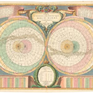
Vincenzo Coronelli’s Idea dell’Universo is a fine Baroque Cosmographia produced at the dawn of the Enlightenment. This stunning cosmological chart was printed across two folio sheets in the first volume of Coronelli’s iconic atlas, the Atlante Veneto (1691). The composite engraving features a large central diagram accompanied by numerous subsidiary figures, graphs, and tables. The two-sheet format allowed Coronelli to pack an enormous amount of detail, much of which is labelled in detail with engraved captions in Italian.
At the very top are two ornate title banners reading “Idea dell’” and “Universo” flanking a large circular diagram labelled “Ordine di tutte le sfere, con la loro dichiaratione” on a banner carried by putti. This is a traditional Ptolemaic nested‐sphere diagram: a schematic cosmological model that represents the universe as a series of concentric spheres, each enclosing the next, usually with Earth at the center. In this case, however, the innermost circle is Hell itself, complete with devils and subdivided into ten circles (Limbo, Purgatory, etc.). Only in the subsequent circle do we find our earthly domain, which Coronelli has depicted cartographically in four continental quadrants. The outermost ring (Decima Sfera Primo Mobile) is segmented into 24 hours, which are then subdivided into the 36,000 parts, or “Great Year” cycle, required for all the planets to return to their zodiacal starting positions. The inclusion of this universal calendar reflects Coronelli’s inclusion of some of the latest astronomical observations and hypotheses in his chart.
Below the nested sphere sits a vast astrological planisphere, constituting the central motif. This is a large astrological chart containing vignettes of the zodiac, planetary orbit data, and a wealth of annotations in concentric rings of tables and texts. The central diagram is surrounded by four circular calendrical tables showing solar phases at the top and lunar phases at the bottom, and tabulating the times of sunrise, midday, new moon, and full moon. Along the bottom, inset lettered panels and tables are arranged, and above them, a central cartouche dedicates the chart to Coronelli’s patron, Sebastian Venier.
In the spaces between the central diagrams, we find customary wind-heads: personifications of the four cardinal winds. These are purely ornamental, meant only to enhance the chart’s visual impact. A border of smaller diagrams encloses the entire composition. In unison, these elements form a comprehensive visual compendium of the latest astronomical and cosmological knowledge.
A border of tables and diagrams
The central planispheres are framed by an outer border comprised of 28 small circular diagrams, each of which relays specific information. Coronelli’s annotations inform viewers about the nature of each diagram, identifying, among others, the mechanics of solar and lunar eclipses, astrological aspect grids, and perpetual calendar tables. For those interested in Coronelli as a cartographer, 10 terrestrial maps—showing the world in both hemispheres and continents—have been integrated into these framing diagrams. Also present is a Zodiac Man chart, depicting which body parts are ruled by which zodiac signs, as well as related medical-astrological tables.
In summary, the diagrammatic border combines star charts, eclipse diagrams, miniature world maps, zodiacal and calendrical wheels, and astrological and magical charts to provide cosmographic references for the central planispheres.
Context is Everything
In the Idea dell’Universo, Coronelli explicitly engages the major cosmological models of his day by emphasizing a Ptolemaic (Earth-centered) system, as seen in the nested sphere with Hell at its center. The adjacent text labels it as the “ordering of all the spheres”, which is meant in the Aristotelian sense.
Applying the view of the ancients stands in stark contrast to other celestial charts in the same atlas, which present the rival—and more modern—Copernican and Tychonic models (after Tycho Brahe). In the Copernican system, planets orbit a central Sun. In contrast, the Tychonic scheme employs a geocentric model in which the Sun orbits a fixed central Earth, with the other planets orbiting the Sun.
The inclusion of complex cosmological charts in the first volume of the Atlante Veneto reflects a 17th-century trend toward encyclopaedic atlases. However, juxtaposing the contrasting cosmographic systems also served to demonstrate how informed Coronelli and his argonauts were. Thus, while the formal aim may have been to present a comprehensive and authoritative view of the cosmos, Coronelli also used celestial charts to address the competing cosmological opinions of his day. The Idea dell’Universo embodies this goal by visualizing both traditional and recent astronomical concepts side by side. It assembles classical Ptolemaic astronomy, Renaissance astrology and calendrics, and the latest scholarship (e.g. recognition of the Great Year) into a single large illustration. The presence of explicitly Catholic elements, such as the portrayal of Hell and Purgatory, underscores the Counter-Reformation context in which Coronelli worked.
The chart, in other words, is a complex schematic visualization that merges scientific data with astrological lore and religious symbolism, embodying the early Enlightenment’s quest for scientific truth.
Cartographer(s):
Vincenzo Maria Coronelli (1650 – 1718) was a Franciscan printer, cartographer, and globe-maker from Venice. Due to his religious background, many of his charts have been signed P. Coronelli, meaning Père or ‘Father’, and referring to his status as a friar of the Franciscan Order. He was appointed official cosmographer for the city of Venice and was later employed as royal cartographer to the King of France. In particular the latter position meant that he had access to the latest records and materials from French pioneers and voyages of exploration. This caused many of his charts to be cutting-edge innovations that redefined the newly discovered parts of the world in an entirely novel fashion. It also meant that Coronelli would have no scruples in declaring uncontested or virgin land in the New World as part of Nouvelle France. This is exemplified in Coronelli’s celebrated 1685 chart of Western Canada or Nouvelle France, in which the official French territories have been expanded thousands of miles to the west and south, so that most of the Midwest, including the Mississippi Valley, has been subsumed under a French claim.
Coronelli’s access to the latest French sources and intelligence is part of what has made his maps so cartographically decisive and collectible. An example of this is found in his 1688 chart of upper Mexico and the Rio Grande (modern Arizona, California, and parts of New Mexico). This map was, at the time of its publication, one of the most detailed and accurate maps of the Rio Grande on the market. The detailed information conveyed in Coronelli’s map came directly from Diego Penalosa, the Spanish governor of New Mexico (1661-63) who turned rogue and provided the French King with a wealth of strategic geographical information. His ambition was to lure the French into attacking New Mexico from the neighboring territory of Louisiana. Despite the controversial source of his information (or perhaps precisely because of it), Coronelli does not hesitate to lay credit where credit is due, and mentions Penalosa directly in the map’s cartouche.
Condition Description
Very good. Light toning and wear along fold line.
References