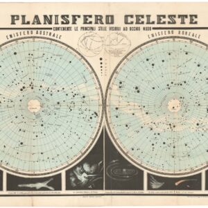
Coronelli’s schematic representation of the heavens on a single sheet.
Planisferii Celesti, Calcolati per l’anno MDCC, Corretti, et Aumentati di Molte Stelle.
$1,600
1 in stock
Description
This is Vincenzo Maria Coronelli’s Planisferii Celesti, a schematic representation of the heavens depicted as a double-hemisphere and designed as a complete astronomical atlas on a single sheet. Rather than pictorial ornamentation, the hemispherical circles are surrounded by inscribed scrolls, panels with astronomical data, and two stunning central cartouches. The large central cartouche above the hemispheres bears Coronelli’s dedication of this chart to Venetian senator Marco Bembo, and is crowned by the Argonauts’ academy star-studded shield.
Flanking the dedicatory cartouche on either side, inscribed scrolls summarize the history of celestial mapping from Ptolemy onward (left) and provide the ecliptic longitudes of a bright Aries star (right), as well as the differences in perception between “Tychean” (after renowned Danish astronomer Tycho Brahe) and “Copernican” paradigms. Below the hemispheres, two tables list precession values at regular intervals, as set by astronomers Tycho Brahe (left) and Giovanni Battista Riccioli (right). This sober layout, with formal borders and inscriptions but no constellation artwork, deliberately prioritizes information over decoration.
Projection, Precession, and Positioning
The sky is charted in a standard azimuthal or polar projection for each of the two hemispheres, with concentric rings marking the key circles, such as the celestial equator, tropics, or ecliptic. Importantly, the chart is explicitly calculated for the year 1700 (MDCC), as indicated by the title inscription along the top of the sheet. Coronelli demonstrates the shift from an earlier epoch to 1700 by tracking the longitude of a 3rd-magnitude star on Aries’ horn (upper-right scroll). Similarly, the precession tables in the lower cartouches show how to adjust older star positions to the new epoch. In essence, this meant that the stellar positions plotted on the hemispheres corresponded to future coordinates, appropriate for the year 1700. Applying the precessional correction in advance cemented Coronelli’s authority among heavenly cartographers of his day.
The chart plots thousands of stars using symbols of varying size to represent a scheme of six magnitude classes. No constellation figures or names are shown, only the naked star field. Coronelli based his star data on the latest catalogs, utilizing the work of contemporary astronomers such as Hevelius, Bayer, and Halley. The plotting of stars according to perceived size was, in other words, standard practice at the time.
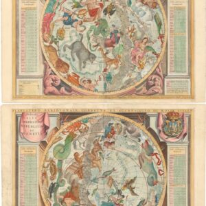
Comparison with Coronelli’s Decorative Planispheres
Coronelli’s Atlante Veneto contained two distinct representations of the heavens. In addition to the present schematic chart, the atlas also included a pair of more richly ornamented zodiac maps entitled Planisfero Settentrionale and Planisfero Meridionale. The pair of planispheres is profusely illustrated with mythological constellation figures and an ornamental Baroque border.
In the Planisferii Celesti chart, no such figures appear: only plain dots mark stars. The individual planisphere plates employ a polar stereographic projection that centers on the celestial poles, essentially providing a geocentric view. In contrast, the double-hemisphere presentation presents both halves of the sky as coordinate grids. In sum, the Planisferii Celesti may be classified as a purely informational star map. By contrast, the individual pictorial planispheres include constellation artwork and astrological iconography.
Cartographer(s):
Vincenzo Maria Coronelli (1650 – 1718) was a Franciscan printer, cartographer, and globe-maker from Venice. Due to his religious background, many of his charts have been signed P. Coronelli, meaning Père or ‘Father’, and referring to his status as a friar of the Franciscan Order. He was appointed official cosmographer for the city of Venice and was later employed as royal cartographer to the King of France. In particular the latter position meant that he had access to the latest records and materials from French pioneers and voyages of exploration. This caused many of his charts to be cutting-edge innovations that redefined the newly discovered parts of the world in an entirely novel fashion. It also meant that Coronelli would have no scruples in declaring uncontested or virgin land in the New World as part of Nouvelle France. This is exemplified in Coronelli’s celebrated 1685 chart of Western Canada or Nouvelle France, in which the official French territories have been expanded thousands of miles to the west and south, so that most of the Midwest, including the Mississippi Valley, has been subsumed under a French claim.
Coronelli’s access to the latest French sources and intelligence is part of what has made his maps so cartographically decisive and collectible. An example of this is found in his 1688 chart of upper Mexico and the Rio Grande (modern Arizona, California, and parts of New Mexico). This map was, at the time of its publication, one of the most detailed and accurate maps of the Rio Grande on the market. The detailed information conveyed in Coronelli’s map came directly from Diego Penalosa, the Spanish governor of New Mexico (1661-63) who turned rogue and provided the French King with a wealth of strategic geographical information. His ambition was to lure the French into attacking New Mexico from the neighboring territory of Louisiana. Despite the controversial source of his information (or perhaps precisely because of it), Coronelli does not hesitate to lay credit where credit is due, and mentions Penalosa directly in the map’s cartouche.
Condition Description
Very good.
References