Coronelli’s Paired Celestial Planispheres: a new take on the heavens – in stunning color.
Planisfero Meridionale, Corretto, et Accresciuto di Molte Stelle & Planisfero Settentrionale, Corretto, et Accresciuto di Molte Stelle.
$4,800
1 in stock
Description
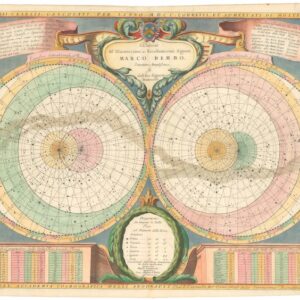
Vincenzo Maria Coronelli’s famous multi-volume atlas, the Atlante Veneto, opens with two large circular star charts entitled the Planisfero Settentrionale and Planisfero Meridionale. On both charts, the stars are rendered using an azimuthal polar projection, indicating that the hemispheres are centered on the celestial North and South Poles, respectively. By depicting the heavens in this manner, the celestial equator appears as an inner concentric circle, while the horizon circles indicate declination bands from 16° to 66°.
A horizontal banner across the top of each chart bears the titles in Italian. In the upper left corner, a dedicatory cartouche reads “Al Serenissima Repubblica di Venetia,” and across from that, we find the coat-of-arms of the Venetian Republic (i.e., the winged lion of Saint Mark). A second inscription along the bottom of each chart credits Coronelli – the Cosmografo della Serenissima Republica di Venetia – as the author. It also notes that the charts were prepared by the Accademia Cosmografica degli Argonauti and calculated for the epoch 1700.
Each hemisphere is flanked by vertical panels respectively listing and positioning the Stelle dell’Emisfero Meridionale (Stars of the Southern Hemisphere) and Stelle dell’Emisfero Settentrionale (Stars of the Northern Hemisphere). In the lower-left quadrant of each chart, a six-tier legend correlates dot size to star magnitude. Baroque scrollwork and architectural piers frame the hemispheres themselves. This symmetrical ornamentation visually unifies these charts as a pair, but we shall return to this later.
Constellations: Classical vs. Modern
Coronelli includes all 48 Ptolemaic constellations visible in each hemisphere: for example, Ursa Major, Andromeda, and most of our zodiac in the north; and Centaurus and Hydra in the south. Notably, Coronelli depicts the new southern constellations introduced by Pieter Dircksz Keyser and Frederick de Houtman in 1596. Many of these are directly inspired by the discovery of the New World (e.g. the Toucan, Indiano, Columba, and Rhombus/Reticulum). A key inclusion on the southern hemisphere is the maritime constellation Naue d’Argo, after which Coronelli’s academy was named. This connection is noted by the image of the ship.
For the star positions and their magnitudes, Coronelli drew on a variety of sources, including Johann Bayer’s Uranometria (1603), Johannes Hevelius’s Firmamentum Sobiescianum (1690), and Edmond Halley’s catalogue of southern stars observed at Saint Helena (1678–79). Despite compiling these charts in the 1680s, Coronelli corrected for precession to the 1700 epoch, and cross‑checked discrepancies among the listed authorities. To maintain visual clarity, Coronelli deliberately omits right-ascension and declination lines on the star field itself, relying instead on the implied polar grid of concentric equator and ecliptic circles.
Coronelli’s workshop employed precise line engraving, with fine hatching to denote the Milky Way and stippling for dense star fields. The lettering is clear and legible, featuring constellation names in Latin and Italian. Dot sizes accurately reflect relative magnitudes, and the marginal tables provide quantitative scales for navigational use. Issued by the newly founded Accademia Cosmografica degli Argonauti, these planispheres served both academic and navigational communities, used for lunar-distance calculations, star-sighting navigation, and scholarly presentations in learned societies.
While each chart stands independently, their mirrored layout, identical decorative frames, and shared cartographic conventions affirm their design as a unified pair. The northern planisphere emphasizes classical Greco-Roman constellations, while the southern introduces newer figures reflecting Portuguese and Dutch exploratory astronomy. Together, they provide a complete celestial reference that combines accuracy with the elegance of the Italian Baroque.
Census
The charts were published in Coronelli’s iconic atlas, the Atlante Veneto (1691). This monumental work combined terrestrial, maritime, and celestial charts and was published under the patronage of the Venetian Senate. Coronelli’s earlier commission in Paris (1681–1683) to construct globes for Louis XIV had granted him access to French cartographic data via Jean-Baptiste Nolin. This collaboration enriched his knowledge of southern skies, supplementing Dutch and German sources and enabling him to produce these decisive celestial representations.
Cartographer(s):
Vincenzo Maria Coronelli (1650 – 1718) was a Franciscan printer, cartographer, and globe-maker from Venice. Due to his religious background, many of his charts have been signed P. Coronelli, meaning Père or ‘Father’, and referring to his status as a friar of the Franciscan Order. He was appointed official cosmographer for the city of Venice and was later employed as royal cartographer to the King of France. In particular the latter position meant that he had access to the latest records and materials from French pioneers and voyages of exploration. This caused many of his charts to be cutting-edge innovations that redefined the newly discovered parts of the world in an entirely novel fashion. It also meant that Coronelli would have no scruples in declaring uncontested or virgin land in the New World as part of Nouvelle France. This is exemplified in Coronelli’s celebrated 1685 chart of Western Canada or Nouvelle France, in which the official French territories have been expanded thousands of miles to the west and south, so that most of the Midwest, including the Mississippi Valley, has been subsumed under a French claim.
Coronelli’s access to the latest French sources and intelligence is part of what has made his maps so cartographically decisive and collectible. An example of this is found in his 1688 chart of upper Mexico and the Rio Grande (modern Arizona, California, and parts of New Mexico). This map was, at the time of its publication, one of the most detailed and accurate maps of the Rio Grande on the market. The detailed information conveyed in Coronelli’s map came directly from Diego Penalosa, the Spanish governor of New Mexico (1661-63) who turned rogue and provided the French King with a wealth of strategic geographical information. His ambition was to lure the French into attacking New Mexico from the neighboring territory of Louisiana. Despite the controversial source of his information (or perhaps precisely because of it), Coronelli does not hesitate to lay credit where credit is due, and mentions Penalosa directly in the map’s cartouche.
Condition Description
Very good. Wear along fold lines, especially towards margins.
References