1693 Collins Nautical Chart of Fowey and Mounts Bay.
[Fowey & Mounts Bay]
$300
1 in stock
Description
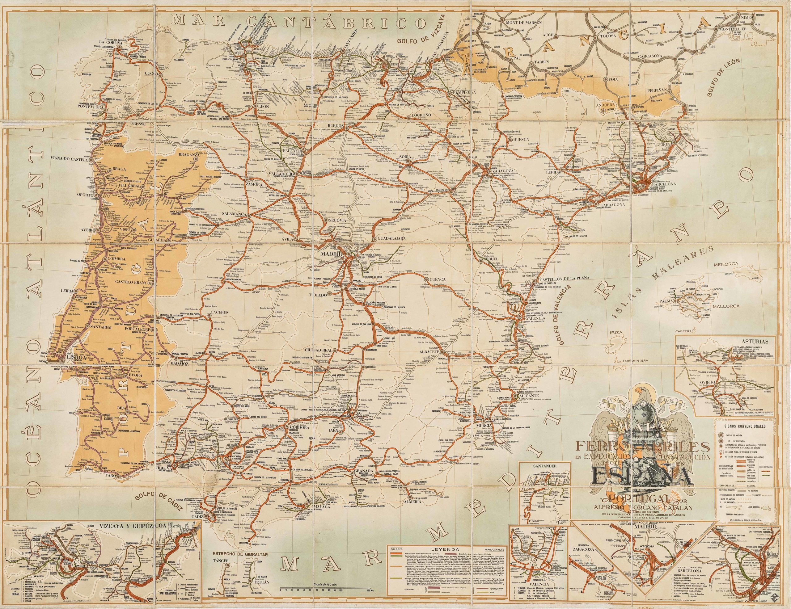
Three Views of Cornwall’s Far Southwest, from Collins’s Coasting Pilot
This richly composed plate from Captain Greenville Collins’s Great Britain’s Coasting Pilot of 1693 surveys the far southwestern extremity of Cornwall across three distinct graphic registers, combining a main coastal chart, a dedicated inset of Mounts Bay, and a coastal recognition profile on a single sheet. It is dedicated to the Right Reverend Father in God Jonathan, Lord Bishop of Bristol, its ecclesiastical patronage and strikingly architectural cartouche setting it apart from the more conventionally naval dedications elsewhere in the atlas.
The Map in Detail
The main chart occupies the lower two-thirds of the plate, tracing the coastline from Dodman Point west to Gwennap Head and the Lizard peninsula beyond. The prominent headland of the Dodman and the wide arc of Veryan Bay are rendered in the characteristic green and cream wash of the series. Fowey harbor, with its twin guardian castles of St Catherine’s and Place, is laid out on the right-hand margin, its narrow tidal estuary and the village of Polruan on the opposing bank clearly delineated. The upper-left inset provides a dedicated chart of Mounts Bay, giving the anchorage below St Michael’s Mount, the quay at Penzance, and the fishing village of Mousehole a designated sounding area. Beneath it, a third panel offers a coastal recognition profile featuring a low silhouette of headlands and church towers as they present to a vessel standing off the Fowey entrance, with Coombe Farm, Fowey Castle, and St Saviour’s chapel at Polruan all identified. The dedicatory cartouche is one of the most architectural in the series, a scroll supported by two standing apostolic figures in colored robes, surmounted by a miter and heraldic shield. A three-masted man-of-war standing under sail in the lower left adds a further decorative dimension.
Historical Context
The dedication to Jonathan Trelawney, Lord Bishop of Bristol, connects this chart to one of the most celebrated Cornish figures of the late seventeenth century. Trelawney was a West Country man of deep Cornish roots, and one of the Seven Bishops imprisoned by James II in 1688 for refusing to read the Declaration of Indulgence from the pulpit, an act of defiance that made him a popular hero and contributed to the collapse of James’s support. His prominence in the region and his association with the resistance to James made him a fitting patron for a chart produced in the early years of the Williamite settlement. The ecclesiastical character of the cartouche, with its apostolic figures, miter, and heraldic shield, reflects this patronage directly, and the Cornish connections of both Collins and his dedicatee may account for the particular care lavished on this corner of the atlas. Cornwall’s southern harbors, including Fowey and the anchorages of Mounts Bay, were active centers of the fishing trade and coastal commerce, and the combination of regional overview and localized harbor detail that characterizes this sheet precisely met their practical navigational needs.
Publication History and Census
This chart appears as a plate in Great Britain’s Coasting Pilot, first published in London in 1693. The plates were reprinted throughout the eighteenth century by the Mount publishing dynasty, first as Mount & Page and later as Mount & Davidson, and surviving sheets are most commonly encountered as individual disbound leaves.
Cartographer(s):
Captain Greenville Collins (c. 1643–1694) was an English naval officer and pioneering hydrographer whose work laid the foundation for systematic coastal charting in Britain. Serving in the Royal Navy during the late seventeenth century, Collins gained practical experience in navigation and surveying at a time when reliable nautical charts of British waters were scarce. Recognizing the strategic and commercial importance of accurate maritime information, the English crown commissioned him in the early 1680s to conduct a detailed survey of the coasts of England and Wales.
Between roughly 1681 and 1688, Collins directed an extensive hydrographic survey of the English coastline, measuring depths, mapping shoals and sandbanks, and documenting harbors and navigational hazards. His work represented one of the first coordinated national charting efforts in England. The results were compiled into Great Britain’s Coasting Pilot, first published in 1693. The volume combined detailed engraved charts with sailing directions and coastal views, providing mariners with far more reliable guidance than previously available.
Collins’s atlas became the standard reference for navigation around British waters for decades and marked an important step in the professionalization of hydrography in England. His methods and charts influenced later surveying practices and helped improve maritime safety during a period of expanding naval power and overseas trade. Collins died in 1694, only a year after the publication of his landmark work, but his contributions established him as one of the earliest significant hydrographers of the British Isles.
Condition Description
Wear along the centerfold and margins. Image is nice.
References