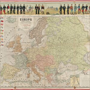
1627 John Speed cartes-à-figures map of Europe with city-views.
Europ, and the cheife Cities contained therin, described; with the habits of most Kingdoms now in use
Out of stock
Description
Splendid carte-à-figures map of Europe, surrounded with vignettes on three sides: five men and five women on the sides, and eight views of cities at the top.
The upper border has eight bird’s-eye city views, of London, Paris, Rome, Constantinople, Venice, Prague, Amsterdam and Lisbon. The side borders contain the costumes of the noblemen and women of ten European nations.
The map shows all of Europe, the northern coast of Africa, and the well-detailed but fictitious island of Frisland just off the coast of Iceland. The seas are alive with sea monsters and ships.
Engraved by Abraham Goos. The impression is rich, the coloring bright.
Verso Text: English
Cartographer(s):
John Speed (1552-1629) was a prominent English mapmaker and historian operating in the late 16th and early 17th centuries. Born in Farndon, Cheshire, Speed’s interest in maps and geography led him to establish himself as a successful mapmaker and publisher in London. He gained widespread recognition for his detailed and beautifully illustrated maps of various regions, earning him the sobriquet “the leading London cartographer” of the Baroque period.
One of Speed’s most notable works is The Theatre of the Empire of Great Britaine, published in 1611. This ambitious atlas consisted of detailed maps of counties and cities across England, Wales, Scotland, and Ireland, accompanied by historical descriptions and genealogical tables. The atlas was not only a cartographic achievement but also a significant historical record of the British Isles during that era. Speed’s maps were praised for their accuracy and artistic flair, often featuring decorative elements and engravings of notable landmarks and figures. When it came to Britain’s colonial aspirations, Speed was instrumental in visualizing the empire cartographically.
Both during his life and after it, John Speed’s maps enjoyed widespread popularity and were sought after by nobility and scholars alike. Speed reached the ripe age of 77, and his maps were re-published for more than a century after his death. His legacy as a key figure in the development of English cartography endures to this day.
Condition Description
Verso tape repair along centerfold, bottom margin extended; some smudges along the top edge, including Prague.
References
Related products
-
-
Add to cart


- Bird's-eye-views, Europe, Italy
Venetia.
- $3,500
-
-
-