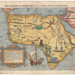
Excellent woodcut map of Africa with Mountains of the Moon and mythical cities.
Africa Tertia Pars Terrae
Out of stock
Description
This is Heinrich Bünting’s c. 1585 decorative Ptolemaic map of Africa from his Itinerarum Sacrae Scripturae. The map, which presents Africa in an unusual shape tapering to a point in the south, is based upon Sebastian Münster’s 1540 map of the continent.
Although the Portuguese had by this point considerable knowledge and experience on the West African coast, the map reflects contemporary European mythology and misperceptions about Africa (such as the mythical kingdom of the Christian king Prester John) as much as the latest discoveries. At the same time, the map does include the Canary Islands and Madeira off Africa’s Atlantic Coast, which were known in earlier sources but not properly located, explored, or settled until the 15th century. Several contemporary North and West African kingdoms, such as Kasa (or Kasanga, here as Casamansa) and Mali (Melli), are also noted.
Cities and kingdoms are recorded throughout. Most of the text is in Latin, but some descriptive notes appear in a different script in German, matching the text on the verso, including labels for the the lands of the ‘White’ and ‘Black Moors’ and the lands of Berbers in North Africa. The stylized wavy seas are dotted with islands, the largest of which, Zaphala, would appear to represent Madagascar. Illustrations of a ship and merman off the southwestern coast of Africa add character to the map.
The Nile is represented according to Ptolemy, with two lakes and the Mountains of the Moon serving as its source. Bunting’s map, however, offers a fascinating deviation from that of Münster in that is also depicts a third large lake – Nidilis lacus – located in Central Africa as a third source for the Nile. On an island in the Nile we see Meroe, which archaeological excavations have revealed to be part of the capital city of the ancient Nubian Kingdom of Kush.
Cartographer(s):
Henrich Bünting was a Protestant theologian and teacher from Hannover who is most renowned for his influential work on Biblical geography. His Itinerarium Sacrae Scripturae, first published in 1581, became very popular due to its comprehensive summary of Biblical geography through travel narratives and commentary. The book contained Bünting’s own unique woodcut maps, including imaginative representations of the continents as a Clover Leaf, Europe personified as a crowned woman, and Asia depicted as the winged horse Pegasus.
With over sixty editions published between 1581 and 1757, Heinrich Bünting’s Itinerarium Sacrae Scripturae remains a significant contribution to the history of Biblical geography.
Condition Description
Two areas of minor repair in the margin at the centerfold. Map image bright and clean.
References
Betz #24.3; Norwich #17; Tooley (MCC-29) #141.