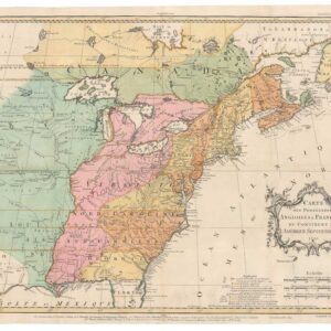
1777 Revolutionary War issue of Homann’s map of the United States
America Septentrionalis a Domino d’Anville in Galliis edita nunc in Anglia Coloniis in Interiorem Virginiam…
Out of stock
Description
This is the Revolutionary War issue of Homann’s map, which was originally published during the French and Indian War in 1756.
This edition includes several alterations and updates, including the line “et ad bellum praesentis temporis accomodata” added to the imprint. It shows the area from James Bay and Newfoundland in the north to northern Florida and the Gulf coast in the south, with British and French possessions during the first full year of the war.
The western extent of the map is just west of the Mississippi River; this area is called “Mississippi or Louisiana.” The boundaries of Virginia, and North Carolina extend westward off the map.
The boundary of New York still appears to cross Lakes Ontario, Huron, and Erie to include the lower peninsula of Michigan, but the western extent is not clearly delineated.
There is an early Georgia, but its boundary ends at the Mississippi River.
The map is embellished with a large title cartouche. The extensive German text at upper left and lower right describes the British claims and French encroachments with historical context.
Cartographer(s):
Johann Baptist Homann (20 March 1664 – 1 July 1724) was a German geographer and cartographer. Homann died in Nuremberg in 1724. He was succeeded by his son Johann Christoph (1703-1730). The company carried on upon his death as Homann heirs company, managed by Johann Michael Franz and Johann Georg Ebersberger. After subsequent changes in management the company folded in 1852.
Condition Description
Minor corner chips and foxing in the margin.
References
McCorkle #756.1; Sellers & Van Ee #68.


![[AMERICAN REVOLUTION] Boston, George Washington, Franklin, Philadelphia, Washington, D.C.](https://neatlinemaps.com/wp-content/uploads/2024/05/NL-02090a_thumbnail-300x300.jpg)