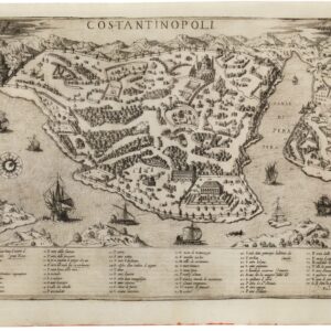
Mid-16th century Lafreri view of Istanbul.
Costantinopoli
Out of stock
Description
This very rare bird’s-eye-view of Constantinople shows the city across the strategic Bosphorus Strait filled with ships. The detailed view depicts the streets and buildings throughout the city, with a lettered key at bottom identifying over 50 important locations. A large compass rose orients north to the top right.
Italian and Greek text on verso. This plan is by Forlani, one of the leading cartographers of the Lafreri School, and published in Giulio Ballino’s De’Disegni delle Piu Illustri Citta, et Fortezze del Mondo in 1569.
The Lafreri School was not actually a school, but a group of cartographers, mapmakers, engravers, and publishers who worked in the major Italian publishing centers of Rome and Venice, from about 1544 to 1585.
Cartographer(s):
Paolo Forlani was an Italian map publisher and engraver based in Venice, especially active between 1560 and 1571.
Condition Description
Light soiling with a minor crease adjacent to the centerfold and remnants of hinge tape on verso.
References
Shirley (BL Atlases) T.BALL-1a #42. Tooley, Imago Mundi, III, no. 160, p. 25.
![PORT OF SAN FRANCISCO. WHERE THE FAR EAST BEGINS [Japanese language version]](https://neatlinemaps.com/wp-content/uploads/2021/01/NL-00879_Thumbnail-300x300.jpg)