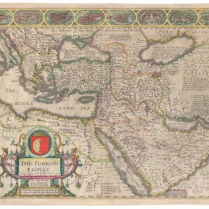
Late 18th century map of the Ottoman Empire with large, striking cartouche.
Empire de la porte Ottomane en Europe, en Asie, et en Afrique avec les pays qui lui sont tributaires, dressé par les freres Lotter
$675
1 in stock
Description
This attractive map details the extent of the Ottoman Empire at the end of the 18th century. It was published at a time in which the Ottomans were in the midst of a series of wars against the Russian Empire. These wars prompted Sultan Selim III to attempt to reform and modernize the Ottoman military.
The map shows Ottoman-controlled areas in Europe, Asia, and Africa: the Balkans, Asia Minor, the Levant, Arabia, and Upper Egypt.
Cartographer(s):
The Lotters were German engravers and cartographers, especially active in the second half of the 18th century.
Condition Description
Minor blemishes. Excellent, thick paper.
References