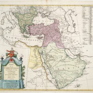
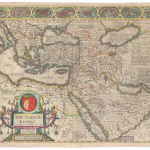
Mid-17th century map of the Ottoman Empire with various Arabian cartographic myths.
Carte Généralle de l’Empire du Turc.
Out of stock
Description
This fine map depicts the Ottoman Empire in an era of transformation — after the so-called classical age which immediately followed the 1453 conquest of Constantinople, but before the era of decline seen in the 18th century.
The cartography of Arabia is similar to other 17th century French maps, with an array of fictitious lakes and mountain ranges located in the interior of the peninsula. There is no real Sinai Peninsula to speak of, and thus no Gulf of Aqaba.
Cartographer(s):
Pierre Mariette I (1569–1657) was an influential French publisher and engraver recognized for developing French cartography and publishing during the early 17th century. Initially, Mariette focused on publishing art prints but pivoted to cartography after purchasing map plates from Melchior Tavernier in 1644. He partnered with Nicolas Sanson, a foundational figure in French cartography, to produce detailed folio maps and atlases. In this collaboration, Sanson provided geographic expertise and map designs, while Mariette managed engraving, printing, and distribution. Their maps often included both their imprints, reflecting their partnership’s close, interdependent nature.
Mariette’s legacy extended beyond his lifetime, though disputes over rights to the plates emerged between Sanson and Mariette’s heirs after Mariette’s death. A legal settlement in 1674 allocated most plates to Sanson’s family, leading to a mixture of attributions in later editions of the maps. Pierre Mariette’s contributions laid the groundwork for the Mariette family, who continued to impact French publishing and mapmaking well into the 18th century, establishing the Mariette name as synonymous with high-quality cartographic and artistic publishing in France.
Condition Description
Soiling and some scattered spots; wear along the margins. Map image very nice.
References