Merian’s spectacular bird’s-eye-view of Venice.
Venetia.
Out of stock
Description
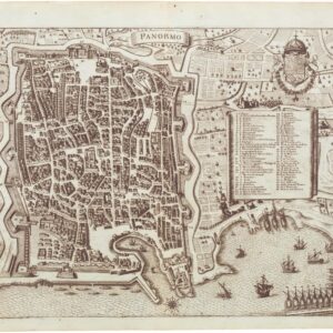
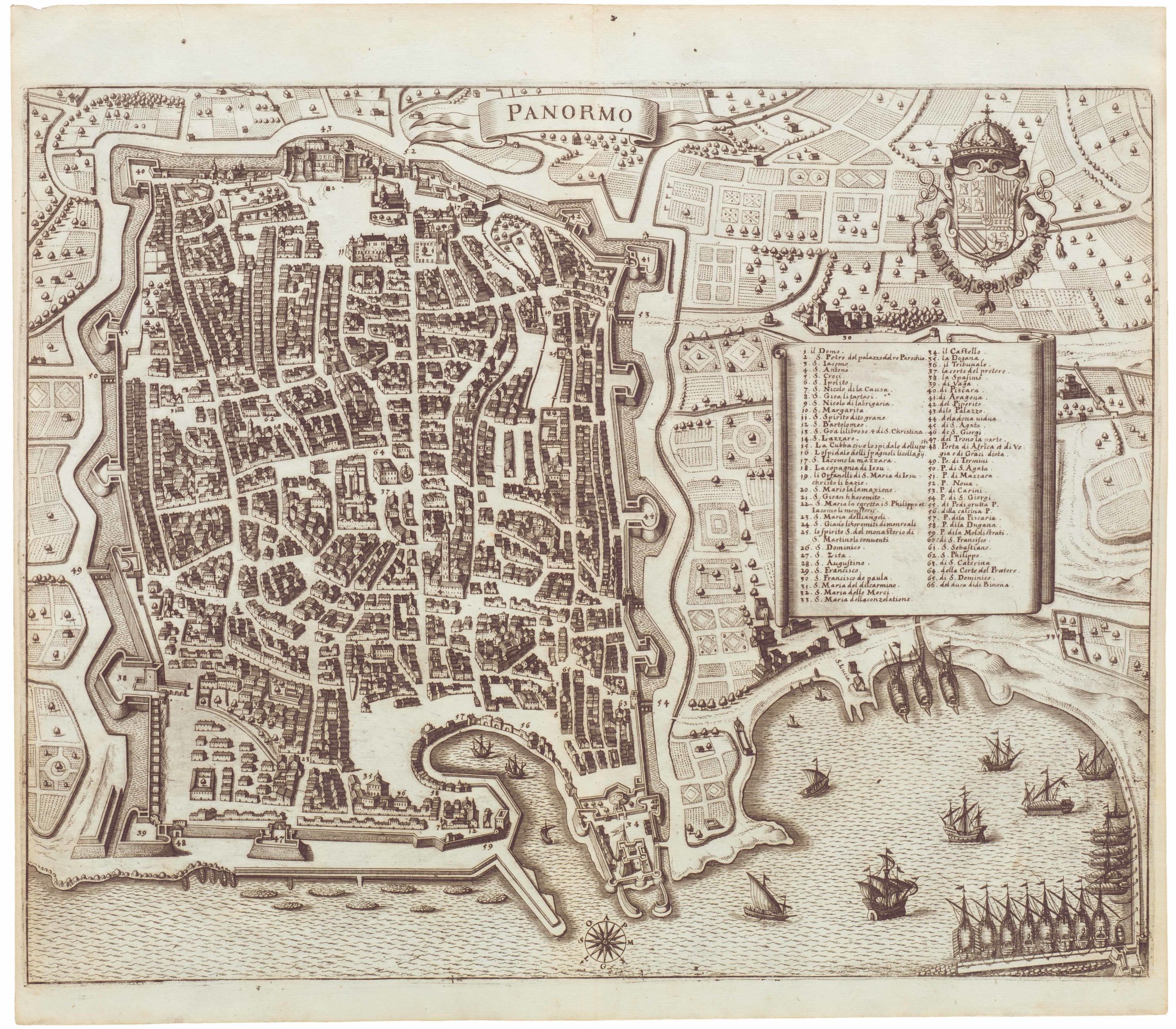
This incredible bird’s-eye-view of Venice was first produced by Matthäus Merian around 1635, at the height of the city’s mercantile power and prosperity. Of the numerous views created of this city on the lagoon, Merian’s is undoubtedly one of the most well-conceived and detailed available to collectors. Published in Frankfurt, the work consists of two adjoining sheets measuring in unison 28 inches (71 cm) wide. In addition to showing the city itself in overwhelming detail, the vista also includes the outer islands, the lagoon, and the rugged coastline of the Veneto hinterland.
Looking north from a fictional highpoint in the Adriatic, just south of Giudecca (a series of small built-up islands fronting Venice to the south), the view provides a comprehensive overview of the city. Among the many finely distinguished elements, the harbor and canals stand out. In the left part of the view, Venice’s most famous waterway, the Grand Canal, winds its way through the bustling city center before culminating in the larger Guidecca Canal, between Piazza San Marco and the island of San Giorgio. In doing so, the Canal not only constitutes one of the city’s main commercial thoroughfares but also connects the inner and outer parts of the lagoon. In the heart of the city, the Canal is traversed by the illustrious Ponte di Rialto, still one of Venice’s most iconic landmarks today.
A large number of specific buildings can easily be identified from Merian’s surpassing view. In many cases, these remain essential historical landmarks in the city today. Most famous among them – and positioned centrally both in the view and in the town – we find the Piazza San Marco, flanked by the Doge Palace and St Mark’s Basilica with its iconic tower. Surrounding the island of Venezia itself, we see some of the many other built-up islands in the lagoon. We have already mentioned the presence of San Giorgio and the Giudecca islands in the forefront of the image, and in the background, beyond Venice, Merian has included the built-up lagoon islands of Murano, Burano, Torcello, and Mazorbo.
In the bottom of the image, the Grand Canal opens onto the Guidecca harbor front, and from here, out into the Adriatic. As Europe’s most important commercial port, Merian portrays Venice’s harbor as bustling with activity featuring many sailing craft and merchantmen, both at anchor and fully rigged. Venice was among the most significant commercial hubs in Europe and a city that linked East and West in the 17th century.
Merian has tried to capture some of this mercantile buzz in his stunning view, yet the composition of ships in the harbor is not merely meant to sound the horn for trade. In the large Canale della Giudecca, we note the presence of the Bucintoro: the official personal barge of the Venetian Doge, or Prince, and a whole entourage of smaller ships accompanying it.
Styled like an ancient Greek trireme and covered in gold leaf, the Bucintoro was a luxurious vessel meant to stun onlookers with its exuberant beauty. Powered by 168 oarsmen and equipped to host diplomatic and state functions, it was a barge designed to impress. In addition to showing off the city’s wealth, the boat served critical ceremonial functions. The most prominent of these was the annual Sposalizio del Mare, in which the Doge was symbolically wed to the Adriatic. The Bucintoro tradition can be traced back to the early 14th century, and the barge was both elaborated and rebuilt several times. By Merian’s day, Venice was on its third iteration, meaning that the barge shown here was the one built for Doge Marino Grimani (1532 – 1605) and completed in 1606.
A final mention should be made of the heraldic crest in the upper right part of the composition. This crest is the Venetian Republic’s official coat-of-arms, as can be gleaned from recognizable Venetian elements like the winged Lion in its center and the asymmetrical cap of the Doge at its crown.
Publication History
The first state of this view was published in 1635 and remains rare. Several amended states were issued in the years following the original publication. Neatline’s example is among the early issues (c. 1640), and all of the plate’s countless details have been faithfully preserved in the printing. The view appeared in several of Merian’s works, including the Theatrum Europaeum, Archontologia Cosmica, and Topographia Italiae, and generally remained popular well into the 19th century. It continued to be printed from the deteriorating plate, causing earlier states to stand out in their minute detail.
Cartographer(s):
Matthäus Merian (September 1593 – 19 June 1650) was a Swiss-born engraver who worked in Frankfurt for most of his career, where he also ran a publishing house. He was a member of the patrician Basel Merian family.
Early in his life, he had created detailed town plans in his own unique style, for example plans of both Basel and Paris (1615). With Martin Zeiler (1589 – 1661), a German geographer, and later (circa 1640) with his own son, Matthäus Merian produced a collection of topographic maps. The 21-volume set was collectively known as the Topographia Germaniae and included numerous town-plans and views, as well as maps of most countries and a world map. The work was so popular that it was re-issued in many editions. He also took over and completed the later parts and editions of the Grand Voyages and Petits Voyages, originally started by Theodor de Bry in 1590. Merian’s work inspired the Swedish royal cartographer, Erik Dahlberg, to produce his Suecia Antiqua et Hodierna, which became a cornerstone in European mapping.
After his death, his sons Matthäus Jr. and Caspar took over the publishing house. They continued publishing the Topographia Germaniae and the Theatrum Europaeum under the name ‘Merian Erben’ (i.e. Heirs of Merian). Today, the German travel magazine Merian is named after him.
Condition Description
Repair visible in left corner, wear and discoloration and minor loss along fold lines.
References
Alois Fauser (1978). Repertorium älterer Topographie. Druckgraphik von 1486 bis 1750 (2 volumes). Wiesbaden: Ludwig Reichert Verlag.
Related products
-
-
Add to cart


- Bird's-eye-views, Europe, Italy
Venetia.
- $3,500
-
-
-